Rheinstetten facts for kids
Quick facts for kids
Rheinstetten
|
||
|---|---|---|

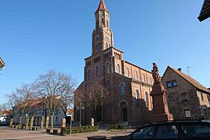
Church of Saint Ulrich in Mörsch
|
||
|
||
| Country | Germany | |
| State | Baden-Württemberg | |
| Admin. region | Karlsruhe | |
| District | Karlsruhe | |
| Elevation | 114 m (374 ft) | |
| Population
(2022-12-31)
|
||
| • Total | 20,659 | |
| Time zone | CET/CEST (UTC+1/+2) | |
| Postal codes |
76276–76287
|
|
| Dialling codes | 07242, 0721 | |
| Vehicle registration | KA | |
| Website | www.rheinstetten.de | |
Rheinstetten is a town in the western part of Baden-Württemberg, a state in Germany. It sits right on the border with another German state, Rhineland-Palatinate. You can find Rheinstetten southwest of the city of Karlsruhe. It is part of the rural Karlsruhe district.
Rheinstetten is the fifth largest city in the Karlsruhe district. It has fewer people living there than Bruchsal, Ettlingen, Bretten, and Stutensee. Since 2005, Rheinstetten has been part of a group called the Technologieregion Karlsruhe. This group works together on things like business, science, culture, and local government.
The town of Rheinstetten was created in 1975. This happened when three smaller towns – Forchheim, Mörsch, and Neuburgweier – joined together. In the year 2000, Rheinstetten officially became a "town." Then, on January 1, 2005, it became a "district seat," which means it's an important center for the local area.
Contents
Exploring Rheinstetten's Location
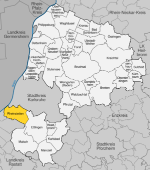
Rheinstetten is located in a flat area called the Upper Rhine Plain. It's about 10 kilometers (about 6 miles) southwest of Karlsruhe. The famous Black Forest is also not far, about ten kilometers to the east.
The Rhine River forms the western edge of Rheinstetten. This river also marks the border between Baden-Württemberg and Rhineland-Palatinate. A small river called the Federbach flows right through the town. To the south, Rheinstetten shares a border with the town of Durmersheim.
A main road, federal highway 36, goes through the city. The main part of Rheinstetten is to the west of this highway. To the south of the highway, you'll find farmland. Further east, there's a forest known as Hardtwald.
How Rheinstetten is Organized
The town of Rheinstetten is made up of three main parts, called districts: Mörsch, Forchheim, and Neuburgweier.
The Forchheim district includes the main village of Forchheim. It also has smaller areas like "Dammfeldsiedlung" and Silberstreifen. You can also find an old house from the 1800s and a farm called "Nußbaumäcker" here. There's even a place called "Derssloch" which used to be a village but is now empty.
The Mörsch district has the village of Mörsch and a gravel pit. Neuburgweier is just the village itself. There are also two places that used to be villages but are now empty within Neuburgweier: "Königsmörsch" and "Staudendorf."
Besides being a district, Neuburgweier is also known as an "Ortschaft." This means it has some special rights under the local laws of Baden-Württemberg.
Neighboring Towns and Cities
Rheinstetten has several neighbors. On the same side of the Rhine River, you'll find:
- Karlsruhe
- Ettlingen (in the Karlsruhe district)
- Durmersheim
- Au am Rhein (in the Rastatt district)
Across the Rhine River, in the state of Rhineland-Palatinate, is the city of Neuburg am Rhein.
Rheinstetten's History
Rheinstetten was officially created on January 1, 1975. This was part of a big plan to reorganize local governments in Baden-Württemberg. The three communities of Forchheim, Mörsch, and Neuburgweier decided to merge and form Rheinstetten.
By 1993, Rheinstetten had grown to 23,000 people. This made it the largest community in Baden-Württemberg that wasn't officially a "town." So, on January 1, 2000, it was finally given "town privileges." Even though it was a large town, it didn't ask to become a "district seat" until 2004. On September 14, 2004, the government of Baden-Württemberg decided that Rheinstetten would become a district seat starting in 2005.
Stories of Rheinstetten's Districts
Forchheim's Past
The area of Forchheim was first mentioned in a written record in 1086. It was called ‘Vorechheim’ and was noted as a gift from Henry IV, Holy Roman Emperor. Until about 1100, Forchheim was a very important area, known as County Forchheim.
Over time, the control of this area changed hands. It eventually came under the rule of the Roman Catholic Diocese of Speyer. Later, it was given to Herman V, Margrave of Baden-Baden, then returned to the county, and in 1219, it went back to Herman V. He became the main lord of Forchheim.
Later, Forchheim was managed by a place called Mühlburg. When lands were divided, it became part of the Margraviate of Baden. At this time, it was managed from Ettlingen. In 1921, it became part of the Karlsruhe district office, which later became the Karlsruhe district in 1938.
Since 1963, a company called Bruker has had its main office in Silberstreifen. Bruker makes scientific tools for studying tiny molecules and materials. They have more than 4,000 employees.
Mörsch's Beginnings
Mörsch was first mentioned in a document in 940. It was called 'Meriske' when Emperor Otto III gave the village to the Roman Catholic Diocese of Speyer. In the 1100s, the Eberstein family ruled over the village.
Eventually, Mörsch became part of the lands of Margrave Hermann VIII of Baden. In 1306, he sold it to the Abbey of Herrenalb, but he was able to buy it back later. By 1291, most of the village belonged to the Weißenburg monastery, which then owned the whole village by 1339.
In 1350, Mörsch finally became part of Baden, managed from Mühlbürg. When lands were divided in 1535, Mörsch went to the Baden-Baden family. It was then managed from Ettlingen. After that office closed, Mörsch became part of the Karlsruhe district.
Neuburgweier's Story
Neuburgweier was first mentioned in a document in 1219. This document talked about how the Eberstein brothers divided their property. In 1383, Neuburgweier became part of the Electorate of the Palatinate. The name "Wilre" (meaning "Weiler" or "hamlet") was first seen in a document in 1396. The name "Neuburgweiler" appeared in 1422.
The village was always linked to Neuburg am Rhein. It was part of the Palatine district of Hagenbach-Germersheim. In the 1500s, Neuburgweier became separated from Neuburg because the Rhine River changed its path naturally.
In 1674, French soldiers took over the village. It was given to the French in 1682 and stayed under French control until 1697. In 1707, through an exchange of lands, the village became part of the Margraviate of Baden-Baden. It was then managed from Ettlingen. After the Ettlingen district closed in 1937, Neuburgweier became part of the Karlsruhe district.
On January 1, 1975, Forchheim, Mörsch, and Neuburgweier joined together to form the new municipality of Rheinstetten.
How Rheinstetten's Population Grew
Here's how the number of people living in Rheinstetten has changed over the years. These numbers come from official counts.
| Date | Population |
|---|---|
| 31 December 1975 | 17,936 |
| 31 December 1980 | 18,814 |
| 27 May 1987 | 19,065 |
| 31 December 1990 | 19,405 |
| 31 December 1995 | 20,046 |
| 31 December 2000 | 20,333 |
| 31 December 2005 | 20,406 |
| 31 July 2006 | 20, 299 |
Religion in Rheinstetten
The area of Rheinstetten was originally part of the Roman Catholic Diocese of Speyer. There has been a Catholic church in Forchheim dedicated to Saint Martin since 1408. This church was the main church for the areas of Forchheim, Mörsch, and Daxlanden (which is now part of Karlsruhe).
Because Mörsch and Forchheim were connected to Baden-Baden, which did not join the Protestant Reformation, they remained Catholic. Neuburgweier had become Protestant because of its ties to the Palatinate region. However, during the French occupation, it became Catholic again.
Mörsch has had its own church administration since the Middle Ages. The Margraves of Baden became the main supporters of the church there in 1567. Since the 1400s, Neuburgweier was part of the Mörsch church area. In the 1600s, the churches of Forchheim and Mörsch (including Neuburgweier) joined together. But this merger was undone in 1907. Neuburgweier belonged to Mörsch until 1962, when it got its own church area.
The current Catholic church in Forchheim was built in 1857/1858. A small forest chapel called "Maria Hilf," built in 1950/51 in Silberstreifen, also belongs to the Forchheim church. The Catholic church in Mörsch, which looks like an early Christian church, was built in 1846/47.
The St. Ursula Chapel in Neuburgweier was first mentioned in 1495. In 1776, the main part of the chapel was rebuilt. In 1871, it was made bigger and renovated in a Gothic style. The current Catholic church of St. Ursula was built in 1952. Since September 18, 2005, the three Catholic churches in Rheinstetten have worked together as one Catholic group.
A priest named Anton Fränznick worked in Mörsch in the 1920s and 30s. He was killed because of his actions in a resistance movement.
After World War II, Protestant people also moved to Rheinstetten. At first, they were looked after by the nearby town of Durmersheim. On January 1, 1971, the Protestant church area of Forchheim was created. Three years later, this area was renamed Rheinstetten. In 1979, a second Protestant church leader was assigned to the Mörsch and Neuburgweier districts. In 1984, they formed their own Protestant church area. The Protestant church building in Forchheim was built in 1972. In 1981, Mörsch built its Protestant church building. In Neuburgweier, Protestants got the old St. Ursula chapel in 1954, after the new Catholic St. Ursula church was built.
Rheinstetten's Partner Cities
Rheinstetten has special friendships with other cities around the world. These are called twin towns:
See also
 In Spanish: Rheinstetten para niños
 | Leon Lynch |
 | Milton P. Webster |
 | Ferdinand Smith |


