Rhwng Gwy a Hafren facts for kids
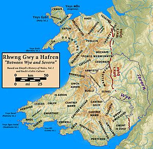
Rhwng Gwy a Hafren (say "Hroong Gwee ah Hav-ren") was an important area in Wales a long time ago, during the Middle Ages. Its name means "Between Wye and Severn" in Welsh. This region was located between two major rivers, the Wye (called Gwy in Welsh) and the Severn (Hafren in Welsh).
It was found in the Welsh Marches, which is the borderland between Wales and England. To the north was the Kingdom of Powys, and to the south was Brycheiniog. Today, this area is mostly part of Powys county, similar to what used to be Radnorshire.
Rhwng Gwy a Hafren became its own distinct region around the 800s or 900s. At that time, its leaders ruled independently, not controlled by the bigger kingdoms around them. After the Normans invaded England, this area became a central part of the Welsh Marches. It was often a place where Welsh and Norman armies fought.
Contents
What Does Rhwng Gwy a Hafren Mean?
The name Rhwng Gwy a Hafren shows up in old lists from the Middle Ages. These lists describe different parts of Wales, like cantrefs and commotes. In Latin writings by Gerald of Wales, the name also appears. It clearly means "between the Wye and the Severn". These two rivers were the most important natural borders for the region.
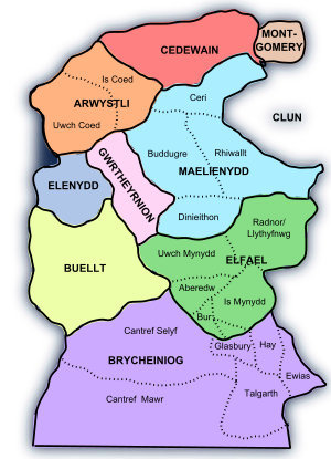
However, the exact lands included in Rhwng Gwy a Hafren could change. Usually, the lists included the cantrefs of Elfael and Maelienydd. They also often included the commote of Gwrtheyrnion. The cantref of Buellt was also often linked to the region, even though it was across the Wye River. Some people even think Arwystli might have been part of it too.
Smaller areas like Ceri (in Maelienydd) and Cwmwd Deuddwr (north of Buellt) were also in this general area. They appear in some old records, but they are not always listed as main divisions of Rhwng Gwy a Hafren.
A Look at the History of Rhwng Gwy a Hafren
Early History and Independent Rulers
During the Iron Age and when the Romans were in Britain, Rhwng Gwy a Hafren was part of the land of the Ordovices tribe. In the early Middle Ages, it was connected to the Kingdom of Powys. But later on, the kings of Powys didn't really control this area.
After the 800s or 900s, families who were descendants of figures like Iorwerth Hirflawdd and Elystan Glodrydd ruled the region. Even though these families had ties to Powys, they acted as independent rulers. In the early 800s, another ruling family started in Buellt and Gwerthrynion. They formed a small, independent kingdom. These rulers were not from the Powys royal family.
However, the connection to Powys was never completely forgotten. Old Welsh stories said that Powys's borders reached the Wye River. In 1176, a bishop named Adam Parvipontanus tried to claim Ceri for his church area, the Diocese of St Asaph. He likely based this claim on Powys's old claims over Rhwng Gwy a Hafren.
Norman Influence and Welsh Resistance
Around 1093, much of Rhwng Gwy a Hafren was divided among the Marcher Lords. These were powerful Norman lords who controlled lands along the Welsh border. Important lords like Roger de Montgomerie, Ranulph de Mortimer, and Philip de Braose took parts of the territory.
But the Normans lost some of their power within 50 years. This happened when Cadwallon ap Madog and his younger brother Einion Clud became powerful princes in Elfael and Maelienydd. In 1165, Cadwallon and Einion Clud joined forces with other independent Welsh leaders. They marched with a large Welsh army led by Owain Gwynedd to Corwen. There, they defeated the army of Henry II of England.
In 1175, these two brothers traveled to Gloucester. They went as allies of Lord Rhys ap Gruffudd of Deheubarth, a powerful Welsh prince from South Wales.
Later History and English Control
Throughout the 1200s, English Marcher Lords slowly took back control of the area. Roger Mortimer even built a castle at Cefnllys to secure his gains in Maelienydd.
Descendants of Cadwallon and Einion Clud continued to hold some castles in the area until the 1240s. At that time, they switched their loyalty to support Llywelyn the Great. Later, they supported his grandson, Llywelyn ap Gruffudd. Llywelyn ap Gruffudd officially took control of the territory in 1267 under the Treaty of Montgomery.
However, the last native Prince of Wales was defeated by Edward I of England in 1282. After this, most of the Welsh landowners in the area lost their lands. In the 1500s, during the Tudor period, the county of Radnorshire was created from this area. This happened under the various Tudor Laws in Wales Acts. The Welsh language was spoken by most people in the area until the late 1800s.
Cynllibiwg: An Older Name?
Some parts of Rhwng Gwy a Hafren might have been called Cynllibiwg (or a similar name) during the Early Middle Ages. The Red Book of the Exchequer, an English record from the 1200s, mentions a region of seven cantrefs "between Severn and Wye." It says this area was known as Kenthlebiac during the time of Rhys ab Owain of Deheubarth.
This name also appears in a 9th-century text called Historia Brittonum. It describes a wonderful spring in the regione of Cinlipiuc that was full of fish, even though no stream fed it. The Domesday Book from 1086 mentions a place called Calcebuef. Some experts think this is a changed version of Cynllibiwg. They believe it comes from the name of Saint Cynllo.
We don't know the exact size of Cynllibiwg. One historian, Hubert Hall, suggested that the number of cantrefs mentioned in the Red Book should be changed from seven to three. These might have been Arwystli, Maelienydd, and Elfael. The Red Book says these cantrefs were part of Powys a long time ago. But by the 1200s, they were no longer part of Powys. Some people have suggested Cynllibiwg was an early kingdom, but most historians do not mention it often.
 | Isaac Myers |
 | D. Hamilton Jackson |
 | A. Philip Randolph |


