Richland, Iowa facts for kids
Quick facts for kids
Richland, Iowa
|
|
|---|---|
 |
|

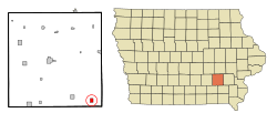
Location of Richland, Iowa
|
|
| Country | |
| State | |
| County | Keokuk |
| Area | |
| • Total | 1.03 sq mi (2.68 km2) |
| • Land | 1.03 sq mi (2.68 km2) |
| • Water | 0.00 sq mi (0.00 km2) |
| Elevation | 778 ft (237 m) |
| Population
(2020)
|
|
| • Total | 542 |
| • Density | 524.18/sq mi (202.33/km2) |
| Time zone | UTC-6 (Central (CST)) |
| • Summer (DST) | UTC-5 (CDT) |
| ZIP code |
52585
|
| Area code(s) | 319 |
| FIPS code | 19-66720 |
| GNIS feature ID | 2396364 |
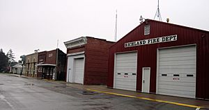
Richland is a small city located in Keokuk County, Iowa, in the United States. In 2020, about 542 people lived there. It's a quiet place in the heart of America.
Contents
Geography of Richland
Richland is a city that covers a total area of about 0.77 square miles (2.0 square kilometers). All of this area is land, meaning there are no large lakes or rivers within the city limits.
People and Population
Richland's population has changed over many years. Here's a look at how many people have lived there at different times:
| Historical populations | ||
|---|---|---|
| Year | Pop. | ±% |
| 1880 | 254 | — |
| 1890 | 531 | +109.1% |
| 1900 | 534 | +0.6% |
| 1910 | 613 | +14.8% |
| 1920 | 639 | +4.2% |
| 1930 | 713 | +11.6% |
| 1940 | 614 | −13.9% |
| 1950 | 591 | −3.7% |
| 1960 | 546 | −7.6% |
| 1970 | 595 | +9.0% |
| 1980 | 600 | +0.8% |
| 1990 | 522 | −13.0% |
| 2000 | 587 | +12.5% |
| 2010 | 584 | −0.5% |
| 2020 | 542 | −7.2% |
| Source: and Iowa Data Center Source: |
||
Richland in 2020
In 2020, there were 542 people living in Richland. These people lived in 235 households, and 152 of these were families. The city had about 524 people per square mile. Most of the people living in Richland were White (93%). A small number were from other racial backgrounds or identified with two or more races. About 2.6% of the population was Hispanic or Latino.
Many households (32.3%) had children under 18 living with them. The average age of people in Richland was about 40.6 years old. Nearly 28% of the residents were under 20 years old. The number of males and females was almost equal.
Richland in 2010
In 2010, Richland had 584 people living in 239 households. The population density was about 758 people per square mile. Most residents (98.5%) were White. A very small percentage were African American, Native American, or from two or more races. About 0.3% of the population was Hispanic or Latino.
About 31.4% of households had children under 18. The average age was 38.6 years. About 27% of residents were under 18. The population was almost evenly split between males (49.1%) and females (50.9%).
Education in Richland
Students in Richland attend schools within the Pekin Community School District. The local high school for students in this area is Pekin Community High School.
History of Schools
Richland used to have its own elementary and secondary school, built in the 1920s. However, in 1959, Richland's school joined the Pekin Community School System. This meant that high schools in Richland, Ollie, Packwood, and Farson closed. Their buildings were then used for younger students. All high school students from these towns started going to a new school building near Pekin.
In 1970, the school system changed again. Junior high schools were closed, and a new middle school opened in Packwood. Students in grades six through eight went to school there. The Richland school building then only served elementary students (kindergarten through fifth grade) from Richland and nearby rural areas like Rubio.
Finally, in 1978, a new school building was finished next to Pekin High School. After this, all students in the district attended classes at this new location. The school buildings in Packwood and Richland were then closed. The Richland school building was torn down on March 17, 2021.
Notable People from Richland
- Paul McCracken (1915–2012) was an important economist. He served as the Chairman of the Council of Economic Advisors from 1969 to 1971. This was during the time Richard Nixon was president.
See also
 In Spanish: Richland (Iowa) para niños
 | Laphonza Butler |
 | Daisy Bates |
 | Elizabeth Piper Ensley |

