
River Derwent, Yorkshire facts for kids
Quick facts for kids Derwent |
|
|---|---|

Barmby on the Marsh Tidal Barrage at the mouth of the River Derwent
|
|

Map of the Catchment Area of the River Derwent
|
|
| Other name(s) | Darwent – archaically |
| Country | England |
| Region | Yorkshire |
| Physical characteristics | |
| Main source | Fylingdales Moor North York Moors, Yorkshire, England 260 m (850 ft) 54°22′50.10″N 0°37′23.79″W / 54.3805833°N 0.6232750°W |
| River mouth | Barmby Barrage Barmby on the Marsh, Yorkshire, England 10 m (33 ft) 53°44′58″N 0°58′08″W / 53.74944°N 0.96889°W |
| Length | 115.1 km (71.5 mi) |
| Basin features | |
| Basin size | 2,057 km2 (794 sq mi) |
| Tributaries |
|
| Designation | |
| Official name: Lower Derwent Valley | |
| Designated: | 17 July 1985 |
| Reference #: | 301 |
The River Derwent is an important river in Yorkshire, England. It flows for about 115 kilometers (71 miles) from its source in the North York Moors all the way to the River Ouse. What's interesting is how it joins the Ouse: it flows into it at a shallow angle, almost as if it's going upstream!
The Derwent's waters are used for many things. People get their drinking water from it, and it's also a place for fun activities like fishing. Plus, it's home to several special nature reserves, making it very important for wildlife.
Contents
- What is the River Derwent Used For?
- How Does Geology Affect the River Derwent?
- What is the Climate Like Around the River Derwent?
- Where Does the River Derwent Flow?
- What is the Barmby Barrage?
- What Wildlife Lives in the River Derwent Area?
- What is the History of the River Derwent?
- What is the Economy of the River Derwent Area Like?
- Settlements Along the River Derwent
- Images for kids
- See also
What is the River Derwent Used For?
The River Derwent is very useful! It provides water to big towns and cities like Hull, Leeds, York, and Scarborough. This means millions of people rely on its water every day.
The river's water is usually very clean. There are also places along the river where treated wastewater is released, but the river's quality remains good.
How Does Geology Affect the River Derwent?

The type of rock under the River Derwent changes along its path. Near its start in the North York Moors, the river flows over limestone from the Jurassic period (that's when dinosaurs lived!). Further downstream, the ground is mostly made of Sherwood sandstone.
Some of these rocks are like giant sponges, holding lots of water underground. These are called aquifers. They are a valuable source of water for the area. The limestone and sandstone aquifers are especially important.
What is the Climate Like Around the River Derwent?
The amount of rainfall around the River Derwent changes depending on the area's height. At its source in the North York Moors, where it's higher up, the river gets more rain, about 1100 millimeters (43 inches) each year. Closer to where it meets the Ouse, at Barmby Barrage, it gets less, around 600 millimeters (24 inches) annually.
Where Does the River Derwent Flow?
The River Derwent flows through different areas, each with its own features. Here's a look at some of them:
East and West Ayton
The Derwent begins its journey at Lilla Rig in the North York Moors. It collects water from smaller streams and then flows south through a narrow valley called Forge Valley. After passing East and West Ayton, it continues across flatter land.
A man-made channel called the Sea Cut helps control flooding. It connects the Derwent to the North Sea near Scarborough. This helps prevent too much water from building up in the lower parts of the Derwent.

River Hertford
The River Hertford starts near Filey and flows west until it joins the Derwent. This area is mostly flat farmland.
Low Marishes
After the River Hertford joins it, the Derwent turns sharply west. It flows through the Vale of Pickering and is joined by the River Rye before reaching Malton. This area has varied landscapes, from flat farmlands to the higher moors and hills.
Kirkham Bridge and Buttercrambe
After leaving Malton, the Derwent flows south through a steep valley called Kirkham Gorge. It passes places like Howsham Mill and Stamford Bridge. These areas are mostly rural with rolling hills and many small villages.

Sutton upon Derwent
The river continues south, cutting through slightly higher land into the Vale of York. This area is mostly flat farmland. The River Derwent here has many special places for nature. It also has a big water pumping station that supplies water to many people.

East Cottingwith
At East Cottingwith, the Derwent winds its way across its flood plain. It collects water from Bielby Beck and the Pocklington Canal. This area is mostly rural with farms and open fields. There are also special meadows called Ings, which are important for wildlife.
Barmby Barrage
The Barmby Barrage is a special structure that separates the Derwent from the tidal River Ouse. This is done to stop the salty tidal water from the Ouse from mixing with the Derwent's fresh water, which is used for drinking.
What is the Barmby Barrage?
The Barmby Barrage is like a big gate on the river. It was built in the 1970s to keep the Derwent non-tidal. This is important because water is taken from the Derwent at Loftsome Bridge to supply the city of Hull.
The barrage has a lock for boats and two large gates. Its main jobs are to:
- Stop water from the Ouse entering the Derwent.
- Keep the Derwent deep enough for boats and for taking water out.
- Keep the river level low enough so that nearby land doesn't flood.
The two gates are very large, each 7 meters wide and 5 meters high. They are controlled by a computer system that uses sensors to know the river levels. When the tide in the River Ouse rises, the gates close. They only open again when the Ouse's water level drops below the Derwent's.
What Wildlife Lives in the River Derwent Area?
The River Derwent, its smaller streams, and the nearby wetlands are very important for nature. They have many different types of habitats and are home to a wide variety of plants and animals. Several areas along the river have special protections:
- Special Protection Areas (SPAs) protect birds, their nests, eggs, and where they live.
- Special Areas of Conservation (SACs) help protect and restore habitats and other species (not birds).
- Ramsar Sites are wetlands that are important around the world.
- Sites of Special Scientific Interest (SSSIs) are places in the UK that are important for their plants, animals, or geology.
| SSSI's | SAC's | SPA's | Ramsar sites |
|---|---|---|---|
| River Derwent, Derwent Ings, Breighton Meadows, Skipwith Common, Melbourne and Thornton Ings, Pocklington Canal, Newton Mask, Kirkham Park and Riverside, Jeffrey Bog, Ellers Wood and Sand Dale, Raincliffe Woods and Forge Valley. | River Derwent, Skipwith Common, Lower Derwent Valley, Ellers Wood and Sand Dale, North York Moors. | Lower Derwent Valley, North York Moors. | Lower Derwent Valley |
What is the History of the River Derwent?
The River Derwent has a long and interesting history, going back to the last Ice Age.
The Ice Age and the River's Path
Before the last Ice Age, the upper part of the Derwent flowed east and emptied into the sea near Scarborough. But during the Ice Age, a huge sheet of ice blocked this path. When the ice melted, it left behind a lot of dirt and rocks, which permanently blocked the eastern exits of the river.
This caused a large lake to form in the Vale of Pickering. Eventually, the water overflowed at its lowest point, cutting a deep valley called Kirkham Gorge. This new path led the water south, and the Derwent joined a large glacial lake that covered the Humber area.
The unusual way the Derwent joins the Ouse (facing upstream) was actually made by people! It's thought that the Romans dug this channel. They wanted to make the journey between the Derwent's mouth and their headquarters in York shorter by about 9 miles.
The first navigation weir (a small dam to control water levels) was also likely built by the Romans near Wheldrake. This helped raise the river level upstream and control its flow downstream.
Medieval Times and Mills
In the 12th and 13th centuries, there were water mills on the Derwent, like one at Wheldrake that belonged to monks. By the 15th century, the river was navigable (meaning boats could travel on it) at least as far as Sutton upon Derwent. Many villages along the river had their own landing places for boats.
In the 18th century, people wanted to improve the river for trade, especially for carrying coal. An Act of Parliament was passed in 1702 to make the river easier to navigate up to Malton. Towpaths were built, and locks and warehouses were added. This allowed people to charge tolls for goods carried on the river.
By 1793, many boats were using the Derwent. They carried grain downstream to towns and brought coal back upstream.
The Arrival of Railways
In 1845, a railway line was built that connected the West Riding to Scarborough, passing through Malton. This was a big change! It was cheaper to transport goods by train, so much of the river's trade moved to the railway. By the late 1800s, only the lower parts of the Derwent were regularly used for trade.
Modern Use and Access
By the early 1900s, the river became more popular for pleasure boats. However, after floods in 1930 damaged some locks, navigation was stopped above Sutton Lock in 1935. Since then, there have been ongoing efforts to ensure public access to the river for recreation.
What is the Economy of the River Derwent Area Like?
The economy around the River Derwent is mainly about its water. The river supplies water to many cities, as well as to farms along its path. It's also a popular spot for fishing, and its many nature reserves are very valuable.
Settlements Along the River Derwent
- Langdale End
- Broxa
- West Ayton
- East Ayton
- Yedingham
- Old Malton
- Malton
- Norton-on-Derwent
- Low Hutton
- Kirkham
- Crambe
- Howsham
- Scrayingham
- Buttercrambe
- Stamford Bridge
- Gate Helmsley
- Low Catton
- Kexby
- Elvington
- Sutton upon Derwent
- West Cottingwith
- Thorganby
- Ellerton
- Aughton
- Bubwith
- Breighton
- Wressle
- Barmby on the Marsh
Images for kids
-
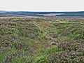
Fylingdales moor
-
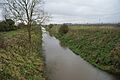
Yedingham
-
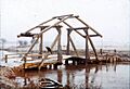
The Old Ings Bridge over the River Derwent at Wheldrake in 1961


See also
 In Spanish: Río Derwent para niños
