Robesonia, Pennsylvania facts for kids
Quick facts for kids
Robesonia, Pennsylvania
|
|
|---|---|

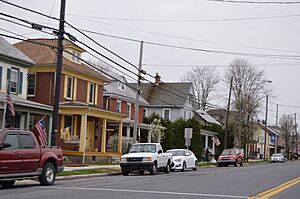
Houses on Penn Avenue
|
|
| Nickname(s):
Robbie
|
|

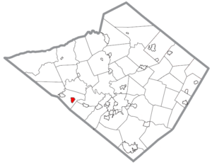
Location of Robesonia in Berks County, Pennsylvania
|
|
| Country | United States |
| State | Pennsylvania |
| County | Berks |
| Area | |
| • Total | 0.89 sq mi (2.31 km2) |
| • Land | 0.89 sq mi (2.31 km2) |
| • Water | 0.00 sq mi (0.01 km2) |
| Elevation | 433 ft (132 m) |
| Population
(2020)
|
|
| • Total | 2,035 |
| • Density | 2,283.95/sq mi (881.97/km2) |
| Time zone | UTC-5 (EST) |
| • Summer (DST) | UTC-4 (EDT) |
| ZIP Code |
19551
|
| Area code(s) | 610 |
| FIPS code | 42-65336 |
Robesonia is a small town, also called a borough, located in Berks County, Pennsylvania, in the United States. In 2020, about 2,035 people lived there.
Students in Robesonia attend schools within the Conrad Weiser Area School District. This includes Conrad Weiser High School.
Contents
History of Robesonia
Robesonia was once famous for its iron factories. These factories, called iron furnaces, operated from around 1794 to 1927. The town itself was started in 1855 by Henry P. Robeson. He bought the existing iron-making businesses and created the Robesonia Iron Company in 1845.
The area where the old iron furnaces stood is now known as the Robesonia Furnace Historic District. It was added to the National Register of Historic Places in 1991. This means it's an important historical site.
Today, some of the biggest employers in Robesonia include C&S Wholesale Grocers, which distributes food, Magnatech International, and Snap-On Tools. The town is also known for its special pottery. This pottery is made in the Pennsylvania German style and is sometimes called redware.
Geography and Climate
Robesonia is located in the western part of Berks County, Pennsylvania. It is surrounded by Heidelberg Township but is a separate area.
The U.S. Census Bureau says that Robesonia covers about 0.9 square miles (2.3 square kilometers) of land. There is almost no water area.
The town has a hot-summer humid continental climate. This means it has warm, humid summers and cold winters. The average temperature changes a lot between seasons. For example, January averages about 29.3°F (-1.5°C), while July averages around 74.2°F (23.4°C). The local hardiness zone is 6b, which helps gardeners know what plants can grow there.
Population and People
| Historical population | |||
|---|---|---|---|
| Census | Pop. | %± | |
| 1880 | 284 | — | |
| 1920 | 1,203 | — | |
| 1930 | 1,468 | 22.0% | |
| 1940 | 1,570 | 6.9% | |
| 1950 | 1,590 | 1.3% | |
| 1960 | 1,579 | −0.7% | |
| 1970 | 1,685 | 6.7% | |
| 1980 | 1,748 | 3.7% | |
| 1990 | 1,944 | 11.2% | |
| 2000 | 2,036 | 4.7% | |
| 2010 | 2,061 | 1.2% | |
| 2020 | 2,035 | −1.3% | |
| U.S. Decennial Census | |||
According to the census from 2010, there were 2,061 people living in Robesonia. There were 855 households and 579 families. The town had about 2,322 people per square mile.
Most of the people in Robesonia were White (92.22%). There were also smaller groups of African American (1.00%) and Asian (1.12%) residents. About 4.42% of the population identified as Hispanic or Latino.
About 28.5% of households had children under 18 living with them. Many households (51.1%) were married couples living together. About 11.8% of households had a female head with no husband present.
The average age of people in the borough was 38 years old. About 24.5% of the population was under 18.
Notable People from Robesonia
- Amy Cuddy, a professor at Harvard Business School and an author
- Robert Gerhart, a former State Senator for Pennsylvania
- Pat Gelsinger, the current CEO of Intel
- G. Gilbert Snyder, a radio broadcaster who spoke Pennsylvania German and was a local school supervisor
Transportation in Robesonia
As of 2007, Robesonia had about 9.77 miles (15.72 kilometers) of public roads. Most of these roads (8.17 miles or 13.15 kilometers) were maintained by the borough itself. The remaining 1.60 miles (2.57 kilometers) were maintained by the Pennsylvania Department of Transportation (PennDOT).
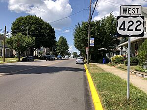
U.S. Route 422 is a main road that goes through Robesonia. It follows Penn Avenue, running from east to west. This route leads 11 miles (18 kilometers) east to Reading and 15 miles (24 kilometers) west to Lebanon.
See also
 In Spanish: Robesonia para niños
 | Emma Amos |
 | Edward Mitchell Bannister |
 | Larry D. Alexander |
 | Ernie Barnes |


