Rockledge, Pennsylvania facts for kids
Quick facts for kids
Borough of Rockledge
|
|||
|---|---|---|---|

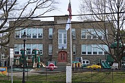
Municipal building on Huntingdon Pike
|
|||
|
|||

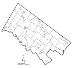
Location of Rockledge in Montgomery County, Pennsylvania.
|
|||
| Country | United States | ||
| State | Pennsylvania | ||
| County | Montgomery | ||
| Government | |||
| • Type | Council-manager | ||
| Area | |||
| • Total | 0.34 sq mi (0.88 km2) | ||
| • Land | 0.34 sq mi (0.88 km2) | ||
| • Water | 0.00 sq mi (0.00 km2) | ||
| Elevation | 223 ft (68 m) | ||
| Population
(2020)
|
|||
| • Total | 2,638 | ||
| • Density | 7,736.07/sq mi (2,989.93/km2) | ||
| Time zone | UTC-5 (EST) | ||
| • Summer (DST) | UTC-4 (EDT) | ||
| ZIP code |
19046
|
||
| Area code(s) | 215, 267 and 445 | ||
| FIPS code | 42-65568 | ||
| Website | http://www.rockledgeborough.org | ||
Rockledge is a small borough located in Montgomery County, Pennsylvania, United States. It's a community where about 2,600 people live, based on the 2020 census. Rockledge is surrounded by Abington Township and the big city of Philadelphia. It also shares a ZIP code with the nearby town of Jenkintown.
Contents
Geography of Rockledge
Rockledge is a very compact place. It covers a total area of about 0.3 square miles (0.8 square kilometers). All of this area is land, meaning there are no large lakes or rivers within the borough's boundaries.
Getting Around Rockledge
Rockledge has several roads that help people get around. In 2007, there were about 7.31 miles of public roads. Most of these roads, about 6.46 miles, are taken care of by the borough itself. A smaller part, about 0.85 miles, is maintained by the Pennsylvania Department of Transportation (PennDOT).
Main Roads and Highways
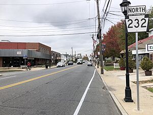
Pennsylvania Route 232 is the main highway that goes through Rockledge. It runs in a northwest-southeast direction and is known as Huntingdon Pike.
Public Transportation Options
If you need to travel without a car, SEPTA offers bus services in Rockledge.
- Route 24 connects Rockledge to the Frankford Transportation Center in Northeast Philadelphia and goes as far as Southampton.
- Route 28 travels between the Fern Rock Transportation Center in North Philadelphia and the Torresdale and Cottman Avenues Loop in Northeast Philadelphia.
The Fox Chase station, which is the end of SEPTA Regional Rail's Fox Chase Line, is also close by in the Fox Chase area of Philadelphia.
People Living in Rockledge (Demographics)
| Historical population | |||
|---|---|---|---|
| Census | Pop. | %± | |
| 1900 | 512 | — | |
| 1910 | 879 | 71.7% | |
| 1920 | 1,029 | 17.1% | |
| 1930 | 1,920 | 86.6% | |
| 1940 | 1,773 | −7.7% | |
| 1950 | 2,261 | 27.5% | |
| 1960 | 2,587 | 14.4% | |
| 1970 | 2,564 | −0.9% | |
| 1980 | 2,538 | −1.0% | |
| 1990 | 2,679 | 5.6% | |
| 2000 | 2,577 | −3.8% | |
| 2010 | 2,543 | −1.3% | |
| 2020 | 2,638 | 3.7% | |
In 2010, most people living in Rockledge were White (95.8%). A small number were Black or African American (0.4%), Asian (1.2%), or from two or more races (2.0%). About 2.0% of the population had Hispanic or Latino family backgrounds.
In the year 2000, there were 2,577 people living in Rockledge. They lived in 1,060 households, and 645 of these were families. The population was quite dense, with about 7,429 people per square mile.
Households and Families
About 28.5% of the households in 2000 had children under 18 living there. More than half (50.3%) were married couples living together. About 7.7% were households led by a woman without a husband present. Many households (39.1%) were not families.
About 34.6% of all households were made up of individuals living alone. Of these, 12.5% were people aged 65 or older living by themselves. On average, there were 2.43 people per household and 3.24 people per family.
Age Distribution
The people in Rockledge were spread across different age groups in 2000:
- 23.6% were under 18 years old.
- 7.6% were between 18 and 24.
- 32.3% were between 25 and 44.
- 21.0% were between 45 and 64.
- 15.5% were 65 years old or older.
The average age in the borough was 38 years. For every 100 females, there were about 91.9 males.
Income Information
In 2000, the average income for a household in Rockledge was $47,958. For families, the average income was $55,455. Men generally earned more, with an average income of $40,349, compared to $32,100 for women. The average income per person in the borough was $21,232.
A small number of families (1.8%) and individuals (3.0%) lived below the Poverty threshold. This included 0.7% of those under 18 and 8.8% of those aged 65 or older.
Famous People from Rockledge
Rockledge has been home to some interesting people:
- Dick McBride was a professional baseball player from 1871 to 1876. He played as a starting pitcher for the Philadelphia Athletics. He is buried in Rockledge at Lawnview Memorial Park.
- Hampton S. Thomas was a brave soldier who received the Medal of Honor during the American Civil War. He is also buried in Rockledge.
Fun Places to Visit in Rockledge
One cool place to visit is the Rockledge Model Railroad Museum. It's located at the corner of Montgomery & Sylvania Avenues. This museum is home to the GATSME Lines Model RR Club. They have amazing model train displays inside a historic building that used to be a textile mill. The club moved to this location in 2014.
See also
 In Spanish: Rockledge (Pensilvania) para niños
 | Sharif Bey |
 | Hale Woodruff |
 | Richmond Barthé |
 | Purvis Young |


