Roosevelt County, New Mexico facts for kids
Quick facts for kids
Roosevelt County
|
||
|---|---|---|

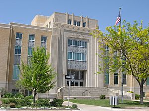
Roosevelt County Courthouse in Portales
|
||
|
||

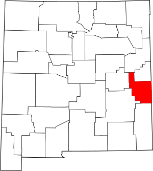
Location within the U.S. state of New Mexico
|
||
 New Mexico's location within the U.S. |
||
| Country | ||
| State | ||
| Founded | February 28, 1903 | |
| Named for | Theodore Roosevelt | |
| Seat | Portales | |
| Largest city | Portales | |
| Area | ||
| • Total | 2,455 sq mi (6,360 km2) | |
| • Land | 2,447 sq mi (6,340 km2) | |
| • Water | 7.2 sq mi (19 km2) 0.3%% | |
| Population
(2020)
|
||
| • Total | 19,191 | |
| • Density | 7.8171/sq mi (3.0182/km2) | |
| Time zone | UTC−7 (Mountain) | |
| • Summer (DST) | UTC−6 (MDT) | |
| Congressional districts | 2nd, 3rd | |
Roosevelt County is a place in the state of New Mexico, USA. It is called a county. In 2020, about 19,191 people lived here. The main town, or county seat, is Portales.
Roosevelt County was created in 1903. It was formed from parts of Chaves and Guadalupe counties. The county was named after Theodore Roosevelt. He was the President of the United States at that time. The eastern edge of the county touches the state of Texas.
Roosevelt County is part of the Portales, New Mexico, area. This area is important for jobs and businesses. It is also connected to the larger Clovis–Portales area.
Contents
Geography of Roosevelt County
Roosevelt County covers a large area. It is mostly land, with a small amount of water.
According to the U.S. Census Bureau, the county is about 2,455 square miles (6,360 km2) in total size. Most of this, about 2,447 square miles (6,340 km2), is land. The rest, about 7.2 square miles (19 km2), is water.
Neighboring Counties
Roosevelt County shares its borders with several other counties:
- Curry County - to the north
- Quay County - to the north
- De Baca County - to the west
- Chaves County - to the west
- Lea County - to the south
- Cochran County, Texas - to the southeast (in Texas)
- Bailey County, Texas - to the east (in Texas)
Protected Natural Areas
Part of the Grulla National Wildlife Refuge is located in Roosevelt County. This refuge helps protect wildlife and their homes.
People of Roosevelt County
The number of people living in Roosevelt County has changed over the years. Here is how the population has grown:
| Historical population | |||
|---|---|---|---|
| Census | Pop. | %± | |
| 1910 | 12,064 | — | |
| 1920 | 6,548 | −45.7% | |
| 1930 | 11,109 | 69.7% | |
| 1940 | 14,549 | 31.0% | |
| 1950 | 16,409 | 12.8% | |
| 1960 | 16,198 | −1.3% | |
| 1970 | 16,479 | 1.7% | |
| 1980 | 15,695 | −4.8% | |
| 1990 | 16,702 | 6.4% | |
| 2000 | 18,018 | 7.9% | |
| 2010 | 19,846 | 10.1% | |
| 2020 | 19,191 | −3.3% | |
| U.S. Decennial Census 1790-1960 1900-1990 1990-2000 2010 |
|||
In 2010, there were 19,846 people living in the county. About 7,299 families lived in homes there. The population density was about 8.1 inhabitants per square mile (3.1/km2).
Many different groups of people live in Roosevelt County. In 2010, about 76.9% of the people were white. About 15.9% were from other races. Also, 39.9% of the people were of Hispanic or Latino background.
The average age of people in the county was about 29.7 years old.
Communities in Roosevelt County
Roosevelt County has several towns and villages.
City
- Portales (This is the main town, or county seat)
Town
Villages
Unincorporated Communities
These are smaller places that are not officially cities, towns, or villages.
Education in Roosevelt County
There are several school districts in Roosevelt County. They help educate the children and teens living there.
- Dora Consolidated Schools
- Elida Municipal Schools
- Floyd Municipal Schools
- House Municipal Schools
- Melrose Public Schools
- Portales Municipal Schools
- Texico Municipal Schools
See also
 In Spanish: Condado de Roosevelt (Nuevo México) para niños
 | William L. Dawson |
 | W. E. B. Du Bois |
 | Harry Belafonte |


