Rostraver Township, Pennsylvania facts for kids
Quick facts for kids
Rostraver Township, Pennsylvania
|
|
|---|---|
|
Township
|
|

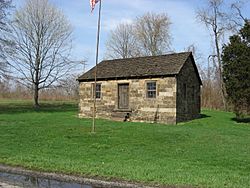
The Old Concord School, built 1830
|
|

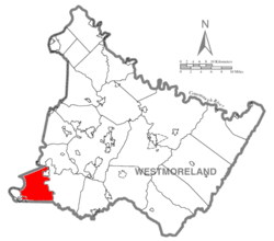
Map of Westmoreland County, Pennsylvania Highlighting Rostraver Township
|
|

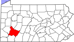
Map of Pennsylvania highlighting
Westmoreland County |
|
| Country | United States |
| State | Pennsylvania |
| County | Westmoreland |
| Area | |
| • Total | 32.95 sq mi (85.34 km2) |
| • Land | 32.28 sq mi (83.61 km2) |
| • Water | 0.67 sq mi (1.73 km2) |
| Population
(2020)
|
|
| • Total | 11,374 |
| • Estimate
(2021)
|
11,361 |
| • Density | 343.52/sq mi (132.63/km2) |
| Time zone | UTC-5 (Eastern (EST)) |
| • Summer (DST) | UTC-4 (EDT) |
| FIPS code | 42-129-66376 |
| Website | http://www.rostraver.us |
Rostraver Township is a community located in Westmoreland County, Pennsylvania, USA. It is a type of local government area called a "township". In 2020, about 11,374 people lived here.
Contents
A Look Back: Rostraver's History
Rostraver Township is found in the southwestern part of Westmoreland County. It has a long history.
Who Lived Here First?
A special place called the Household No. 1 Site is in Rostraver Township. This site was once a village. It was home to the Monongahela tribe, a group of Native American people. This important historical site is now listed on the National Register of Historic Places.
How Did Rostraver Get Its Name?
The name "Rostraver" comes from a place called Rostrevor. This is a seaside town in Northern Ireland. Some of the first settlers in the township, like the McClain family, came from County Down in Ireland. People believe they named their new home "Rostraver" to remember their old village. They likely spelled it the way it sounded to them. However, they didn't leave any written records explaining this choice.
Where is Rostraver Township?
Rostraver Township covers about 32.9 square miles (85.2 square kilometers). Most of this area is land, about 32.2 square miles (83.4 square kilometers). The rest, about 0.7 square miles (1.8 square kilometers), is water.
Neighboring Communities
Rostraver Township shares its borders with many other towns and townships.
Land Neighbors
It has eight land borders. To the north is Elizabeth Township in Allegheny County. West Newton is to the northwest. To the south, you'll find Perry and Washington Townships in Fayette County. To the southwest are North Belle Vernon and Belle Vernon. Monessen is to the west-southwest. Finally, Forward Township in Allegheny County is to the northwest.
River Neighbors
Across the Monongahela River to the west, Rostraver is next to six communities in Washington County. These include Carroll Township, Donora, another part of Carroll Township, Fallowfield Township, North Charleroi, Charleroi, and Speers. The Belle Vernon Bridge on I-70 connects Rostraver to Speers.
Across the Youghiogheny River to the east, Rostraver is mostly next to South Huntingdon. A few other neighbors there are Sewickley Township, West Newton, and Smithton.
Who Lives in Rostraver?
| Historical population | |||
|---|---|---|---|
| Census | Pop. | %± | |
| 1990 | 11,224 | — | |
| 2000 | 11,634 | 3.7% | |
| 2010 | 11,363 | −2.3% | |
| 2020 | 11,374 | 0.1% | |
| 2021 (est.) | 11,361 | 0.0% | |
| U.S. Decennial Census | |||
In 2000, there were 11,634 people living in Rostraver Township. These people lived in 4,590 households. About 3,442 of these were families. The township had about 361.5 people per square mile.
A Look at the People
Most people in the township were White (96.90%). There were also African American (1.94%), Native American (0.12%), and Asian (0.28%) residents. A small number were Pacific Islander (0.03%) or from other backgrounds. About 0.52% of the population was Hispanic or Latino.
Households and Families
Out of all households, 30.8% had children under 18 living there. Most households (60.6%) were married couples living together. About 10.5% had a female head of household with no husband present. Around 25.0% were not families.
About 22.2% of all households had only one person living there. About 10.1% had someone living alone who was 65 years old or older. On average, there were 2.53 people per household and 2.96 people per family.
Age Groups
The population was spread out by age. About 23.4% were under 18 years old. 6.2% were between 18 and 24. The largest group, 28.3%, was between 25 and 44. People aged 45 to 64 made up 25.6%. Finally, 16.5% were 65 years or older. The average age in the township was 41 years.
For every 100 females, there were about 95.3 males. If you only looked at adults 18 and over, there were about 92.5 males for every 100 females.
Income Information
The average income for a household in the township was $39,538. For families, the average income was $48,115. Men earned an average of $36,860, while women earned $26,799. The average income per person in the township was $20,455.
A small number of families (5.5%) and people (6.6%) lived below the poverty line. This included 11.8% of those under 18 and 2.7% of those 65 or older.
Public Services in Rostraver
Rostraver Township has important services to keep its residents safe and healthy.
Police and Fire Protection
The township has its own full-time police force. Their main office is at the municipal complex on Municipal Drive. The Pennsylvania State Police also have a barracks, or station, in Belle Vernon, located on Circle Drive.
Fire protection is provided by three groups of volunteer firefighters. These are the Rostraver Central Fire Department, Webster VFD, and Collinsburg VFC. They respond to calls for help in their areas.
Emergency Medical Services
If someone needs medical help quickly, Rostraver/West Newton Emergency Services is there to respond. They handle emergency medical calls in the area.
See also
 In Spanish: Municipio de Rostraver para niños
 | Shirley Ann Jackson |
 | Garett Morgan |
 | J. Ernest Wilkins Jr. |
 | Elijah McCoy |

