Ruhr facts for kids
Quick facts for kids
Ruhr
Ruhrgebiet
|
||
|---|---|---|
| Ruhr Metropolis Metropole Ruhr |
||
|
||

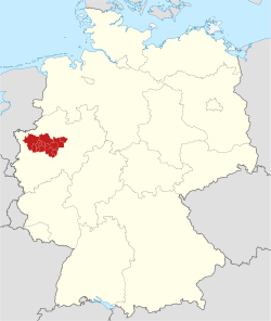
Map of the Ruhr metropolitan region within Germany
|
||
| Country | ||
| State | ||
| Largest cities | ||
| Government | ||
| • Body | Regionalverband Ruhr | |
| Area | ||
| • Metro | 4,435 km2 (1,712 sq mi) | |
| Highest elevation | 441 m (1,447 ft) | |
| Lowest elevation | 13 m (43 ft) | |
| Population | ||
| • Metro | 5,118,681 | |
| • Metro density | 1,646/km2 (4,260/sq mi) | |
| Time zone | UTC+01:00 (CET) | |
| GRP | 2007 | |
| Nominal | €136 billion | |
The Ruhr is a very important region in western Germany. It is named after the Ruhr River, which flows through it. This area is also known as the Ruhrgebiet or Metropole Ruhr. It is one of the largest urban areas in Europe.
The Ruhr River is about 218 kilometres (135 mi) long. It starts near the town of Winterberg and flows into the Rhine River near Düsseldorf. The river passes through many cities like Arnsberg, Iserlohn, Schwerte, Bochum, and Essen.
Contents
History of the Ruhr Region
The Ruhr region has a long and interesting history. It changed a lot over the centuries.
Early Beginnings and Trade
Many cities in the Ruhr area joined the Hanseatic League during the Middle Ages. This was a powerful group of trading cities. Joining the league helped these cities grow and become centers for business and industry.
The Age of Coal and Steel
Starting in the mid-14th century, people began to mine coal along the Ruhr River. This was a big deal! The region soon became the main center for coal and steel production in Germany. This important industry lasted for over 200 years.
Why Coal and Steel Were Important
Coal was needed to power factories and homes. Steel was used to build everything from trains to bridges. The Ruhr region's coal and steel helped Germany become a strong industrial country. Many people moved to the Ruhr to find work in the mines and factories.
Changing Times: From Industry to Culture
By the mid-20th century, the coal and steel industries in the Ruhr started to decline. Many mines and factories closed down. This was a big change for the region and its people.
New Uses for Old Buildings
Instead of letting the old industrial buildings go to waste, the Ruhr region found new uses for them. Many old factories and mines were turned into cultural centers and places for entertainment. For example, the Zollverein Coal Mine Industrial Complex in Essen is now a UNESCO World Heritage Site. It hosts concerts, art shows, and museums. This transformation shows how the Ruhr region adapted and became a vibrant place for arts and culture.
Major Cities in the Ruhr
The Ruhr region is home to many large and important cities. These cities are connected by a network of roads and public transport.
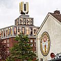
- Dortmund is the largest city in the Ruhr. It is known for its football team and its history in brewing.
- Essen is the second largest city. It is famous for the Zollverein Coal Mine, a symbol of the region's industrial past.
- Duisburg has a large inland harbor, which is one of the biggest in the world.
- Bochum is known for its university, Ruhr University Bochum, and its lively cultural scene.
Transportation in the Ruhr
Getting around the Ruhr region is easy because of its good transportation system.
Roads and Airports
The region has many major highways, like the Bundesautobahn 52 and the A40. These roads connect the cities and make travel simple. Dortmund Airport is located in the east of the Ruhr, making it easy to fly in and out of the region.
Waterways
The Duisburg Inner Harbour is a very important port. It helps move goods by water, connecting the Ruhr to other parts of Germany and Europe through rivers and canals.
Images for kids
-
Zollverein Coal Mine Industrial Complex in Essen, a UNESCO World Heritage Site since 2001
-
Zeche Zollern in Dortmund
-
Dortmund is the largest city of the Ruhr
-
Essen is the second largest city of the Ruhr
-
Bundesautobahn 52 in Mülheim
-
A40 in Dortmund
See also
 In Spanish: Región del Ruhr para niños
 | May Edward Chinn |
 | Rebecca Cole |
 | Alexa Canady |
 | Dorothy Lavinia Brown |


