Rushford Village, Minnesota facts for kids
Quick facts for kids
Rushford Village
|
|
|---|---|

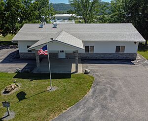
Rushford Village Hall on MN-30
|
|
| Motto(s):
33 square miles strong
|
|

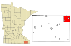
Location of Rushford Village, Minnesota
|
|
| Country | United States |
| State | Minnesota |
| County | Fillmore |
| Area | |
| • Total | 33.73 sq mi (87.35 km2) |
| • Land | 33.51 sq mi (86.78 km2) |
| • Water | 0.22 sq mi (0.58 km2) |
| Elevation | 735 ft (224 m) |
| Population
(2020)
|
|
| • Total | 790 |
| • Density | 23.58/sq mi (9.10/km2) |
| Time zone | UTC-6 (Central (CST)) |
| • Summer (DST) | UTC-5 (CDT) |
| FIPS code | 27-56302 |
| GNIS feature ID | 2396450 |
Rushford Village is a small city located in Fillmore County, Minnesota, in the United States. It is special because it completely surrounds another city called Rushford! In 2020, about 790 people lived here.
Contents
A Look at Rushford Village History
Rushford Village started as a "township" in 1858. A township is a type of local government area. It was named after a nearby stream called Rush Creek.
How Rushford Village Became a City
When the nearby City of Rushford became its own city, Rushford Township became a separate area. Later, on July 18, 1885, Rushford Township changed its status and became a "village."
In 1909, another small village called Peterson also became a village. Interestingly, Peterson is completely surrounded by Rushford Village!
A state law in 1973 changed things for all villages in Minnesota. This law said that all villages would now be called cities. So, in May 1975, Rushford Village officially became an incorporated city, just like it is today.
Where is Rushford Village Located?
Rushford Village is located in the state of Minnesota. The United States Census Bureau tells us that the city covers a total area of about 33.64 square miles (87.13 square kilometers).
Most of this area, about 33.42 square miles (86.56 square kilometers), is land. The rest, about 0.22 square miles (0.57 square kilometers), is water.
Who Lives in Rushford Village?
The population of Rushford Village has changed over the years. Here is a quick look at how many people have lived there during different census counts:
| Historical population | |||
|---|---|---|---|
| Census | Pop. | %± | |
| 1900 | 1,064 | — | |
| 1910 | 686 | −35.5% | |
| 1920 | 663 | −3.4% | |
| 1930 | 633 | −4.5% | |
| 1940 | 634 | 0.2% | |
| 1950 | 612 | −3.5% | |
| 1960 | 581 | −5.1% | |
| 1970 | 601 | 3.4% | |
| 1980 | 688 | 14.5% | |
| 1990 | 705 | 2.5% | |
| 2000 | 714 | 1.3% | |
| 2010 | 807 | 13.0% | |
| 2020 | 790 | −2.1% | |
| U.S. Decennial Census | |||
Population in 2010
According to the census taken in 2010, there were 807 people living in Rushford Village. These people lived in 305 different homes.
The city had about 24.1 people living in each square mile. Most of the people living in the city were White.
Age and Gender in 2010
The average age of people in Rushford Village in 2010 was 43.5 years old.
- About 23.7% of the residents were under 18 years old.
- About 17.3% of the residents were 65 years old or older.
The population was almost evenly split between males and females. About 49.9% were male and 50.1% were female.
See also
 In Spanish: Rushford Village (Minnesota) para niños
 | Madam C. J. Walker |
 | Janet Emerson Bashen |
 | Annie Turnbo Malone |
 | Maggie L. Walker |

