
Rutledge, Pennsylvania facts for kids
Quick facts for kids
Rutledge, Pennsylvania
|
|
|---|---|

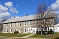
Borough Hall
|
|

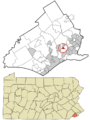
Location in Delaware County and the U.S. state of Pennsylvania
|
|

Rutledge, Pennsylvania
Location in Pennsylvania

Rutledge, Pennsylvania
Location in the United States
|
|
| Country | United States |
| State | Pennsylvania |
| County | Delaware |
| Area | |
| • Total | 0.14 sq mi (0.37 km2) |
| • Land | 0.14 sq mi (0.37 km2) |
| • Water | 0.00 sq mi (0.00 km2) |
| Elevation | 128 ft (39 m) |
| Population
(2020)
|
|
| • Total | 782 |
| • Estimate
(2022)
|
778 |
| • Density | 5,587.41/sq mi (2,157.51/km2) |
| Time zone | UTC-5 (EST) |
| • Summer (DST) | UTC-4 (EDT) |
| ZIP code |
19070
|
| Area code(s) | 610 and 484 |
| FIPS code | 42-045-66928 |
| FIPS code | 42-66928 |
| GNIS feature ID | 1204564 |
Rutledge is a small town, also known as a borough, located in Delaware County, Pennsylvania, in the United States. In 2020, about 782 people lived there. This number was a bit lower than the 860 people who lived there in 2000.
Contents
History of Rutledge
How Rutledge Began
Rutledge was started in 1885 by a group of business people from Philadelphia. It officially became a borough in 1887. A brochure from 1897 described it as a great place to live.
The brochure said Rutledge was "ten miles from Philadelphia." You could get there quickly by train, with 21 trains running daily. It also mentioned the beautiful Swarthmore College nearby and the Delaware River three miles away. The schools were considered excellent, and people took pride in their homes and gardens.
Rutledge Today: Still a Great Place
While some things have changed, like the train line now being called SEPTA's Media/Wawa Line, much of that old description is still true. The train now stops at the Morton-Rutledge Station.
The schools in the Wallingford-Swarthmore School District are still among the best in Pennsylvania. Many homes in Rutledge are very old, some built in the late 1800s, and their owners still care for them with pride.

The Mystery of Rutledge's Name
There's a popular story that Rutledge was named after Ann Rutledge, who was said to be the first love of President Abraham Lincoln. However, this story is not true. You can even see this incorrect legend on the Keystone Marker sign when you enter Rutledge from the south.

The real story is that the town was named after a popular romantic novel called Rutledge, written by Miriam Coles Harris in 1860. Interestingly, the land where Rutledge is now was once part of an estate owned by Edward Rutledge. He was a delegate to the Continental Congress from South Carolina and the youngest person to sign the Declaration of Independence.
A Story of Community Strength
In 1958, George Raymond, who was the president of the NAACP branch in Chester, bought a house in Rutledge. The day before he was supposed to move in, his new house burned down.
After the fire, the local government tried to take Raymond's property. This is called eminent domain, where the government can take private land for public use, even if the owner doesn't want to sell it. They wanted to build a new town hall there. But George Raymond fought back and threatened to take legal action. Because of his strong stand, the township decided not to take his property. His house was rebuilt, and he moved in during 1959.
Geography of Rutledge
Where is Rutledge Located?
Rutledge is in the eastern part of Delaware County. It's almost completely surrounded by Ridley Township. The very northern tip of Rutledge touches the town of Morton. To the south, the area called Folsom (which is part of Ridley Township) borders Rutledge.
The total area of Rutledge is very small, about 0.14 square miles (0.37 square kilometers), and it's all land.
Parks and Services
Rutledge has a special place called Triangle Park, which is a park for children. The Morton-Rutledge Fire Company in Morton helps keep the borough safe from fires. The Swarthmore Police Department provides police services for Rutledge.
Population and People
How Many People Live in Rutledge?
The number of people living in Rutledge has changed over the years. In 1890, there were 269 people. The population grew to 1167 in 1970, but then it slowly decreased. In 2020, the population was 782.
| Historical population | |||
|---|---|---|---|
| Census | Pop. | %± | |
| 1890 | 269 | — | |
| 1900 | 369 | 37.2% | |
| 1910 | 523 | 41.7% | |
| 1920 | 711 | 35.9% | |
| 1930 | 789 | 11.0% | |
| 1940 | 796 | 0.9% | |
| 1950 | 919 | 15.5% | |
| 1960 | 947 | 3.0% | |
| 1970 | 1,167 | 23.2% | |
| 1980 | 934 | −20.0% | |
| 1990 | 843 | −9.7% | |
| 2000 | 860 | 2.0% | |
| 2010 | 784 | −8.8% | |
| 2020 | 782 | −0.3% | |
Who Lives in Rutledge?
According to the 2010 Census, most people in Rutledge were White (91.7%). There were also African American (2.9%) and Asian (3.1%) residents. About 2.3% of the population identified as being of two or more races. A small percentage (1.8%) of the population was Hispanic or Latino.
In 2000, about 40% of households in Rutledge had children under 18 living with them. The average age of people in Rutledge was 38 years old.
Education in Rutledge
Schools for Rutledge Students
Rutledge is part of the Wallingford-Swarthmore School District. This means that public school children living in Rutledge attend specific schools within this district.
Younger students, from kindergarten to 5th grade, go to Swarthmore-Rutledge School. For grades 6 to 8, students attend Strath Haven Middle School. Finally, for high school, from grades 9 to 12, students go to Strath Haven High School.
Rutledge used to have its own school district with just one school, which was located in the building that is now the borough hall. However, the Rutledge and Swarthmore School Districts joined together in 1955 to form the current district.
Transportation in Rutledge
Roads and Avenues
As of 2008, Rutledge had about 3.33 miles of public roads. Most of these roads (2.90 miles) are taken care of by the borough itself. A smaller portion (0.43 miles) is maintained by the Pennsylvania Department of Transportation (PennDOT).
There are no major highways that go directly through Rutledge. The main roads in the borough include Morton Avenue, which runs along the northwestern edge of Rutledge. Another important road is Sylvan Avenue, which goes through the middle of the borough.

Images for kids
-
Borough Hall
-
Location in Delaware County and Pennsylvania
-
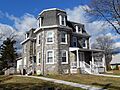
House in Rutledge built 1900
-
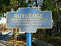
Keystone Marker perpetuating the myth that the borough was named after Ann Rutledge
-
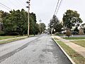
Sylvan Avenue in Rutledge
See also
 In Spanish: Rutledge (Pensilvania) para niños
