Rzepin facts for kids
Quick facts for kids
Rzepin
|
||
|---|---|---|

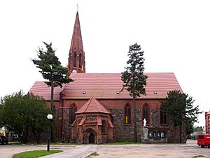
Sacred Heart church in Rzepin
|
||
|
||
| Country | ||
| Voivodeship | Lubusz | |
| County | Słubice | |
| Gmina | Rzepin | |
| Area | ||
| • Total | 11.42 km2 (4.41 sq mi) | |
| Elevation | 50 m (160 ft) | |
| Population
(2019-06-30)
|
||
| • Total | 6,529 | |
| • Density | 571.72/km2 (1,480.7/sq mi) | |
| Time zone | UTC+1 (CET) | |
| • Summer (DST) | UTC+2 (CEST) | |
| Postal code |
69-110
|
|
| Car plates | FSL | |
| Website | http://www.rzepin.pl/ | |
Rzepin is a town located in western Poland. It is part of the Lubusz Voivodeship and is the main town of Gmina Rzepin. Rzepin had a population of 6,529 people in 2019.
Contents
Geography of Rzepin
Rzepin is found in the western part of the Lubusz Lake District. It sits in a long valley formed by glaciers. This area is known as the historical Lubusz/Lebus Land.
Rivers and Lakes
The Ilanka River flows through Rzepin. This river is a branch of the Oder River. South of Rzepin, the Ilanka River meets its smaller branch, the Rzepin River.
A cool thing about the Ilanka River is that it splits into two streams north of Rzepin. This is called a bifurcation. One stream goes into the Łęczna River, which then flows into the Warta River system.
The area around Rzepin has many lakes formed by glaciers. Some of these lakes include Busko, Długie (which has a local swimming beach), Głębiniec, Linie, Lubińskie, Oczko, Papienko, and Rzepsko.
Rzepin Forest History
Rzepin used to own the forests nearby even before the 14th century. However, in 1553, the town lost most of its forest rights. This happened because of a tax mistake made by the town leaders.
In the 18th century, a special royal forest area was set up. Today, the main forest office is still in Rzepin. The term "Rzepin Forest" now mostly refers to the larger Lubusz Forest. This huge forest is located near Rzepin and Torzym in the Lubusz Voivodeship.
What's in a Name?
The name "Rzepin" comes from Slavic languages. Experts believe it might come from words like "repina" (a type of maple), "rjepa" (turnip), or "rjepnik" (a turnip field).
Some also think the name could be linked to the word "ryby," which means "fish." This would suggest it was a fishing village by a river. Today, Polish experts agree that the name likely comes from "Rzepa," which is a Polish nickname for "turnip" or the word for turnip itself.
A Look Back: Rzepin's History
Rzepin was built on the site of an old fort from the 10th century. There was also a village of craftsmen outside the fort. This area was near a good place to cross the Ilanka River.
Rzepin was part of the Lubusz Land. This land belonged to the Kingdom of Poland in the Middle Ages. Later, in the late 1200s, the land was given to the rulers of Brandenburg. After this, Rzepin's history became quite busy. The town was sold many times, and its land was often taken away.
Medieval Rzepin was a town of skilled workers. There were groups of cloth makers, butchers, bakers, and shoemakers. People also made a living by fishing and brewing beer. A water mill was an important part of the town. Rzepin grew quickly, but it also faced challenges like diseases and many fires. One fire even destroyed the old town hall.
From 1373 to 1415, Rzepin was part of the Czech Kingdom. Later, from the 18th century, it became part of Prussia and then Germany. In 1945, after World War II, Rzepin became part of Poland. The people who lived there moved out, and new Polish settlers moved in.
The first mention of Rzepin was in 1297. It talked about a priest from "Repin." In the 14th and 15th centuries, the town was sometimes called "Newen Reppin" or "Nyen Rypin." This might mean it moved to a new, better spot. The old fort's remains are still visible near the Ilanka River.
After World War II, for a short time, the town was called Rypin Lubuski. But since the late 1940s, it has been called Rzepin. It also became the main town for the Rzepin area.
Key Dates in Rzepin's History (1850–1945)
- 1869: A railway line was built connecting Frankfurt (Oder) to Rzepin and Poznań.
- 1875: Another railway line was built from Szczecin to Rzepin and Głogów.
- 1881: A hospital was built.
- 1890: A railway line was built from Rzepin to Ośno Lubuskie, Sulęcin, and Międzyrzecz.
- 1904: Rzepin became the main town of Rzepin County.
- 1911–1913: New primary and secondary schools were built.
- 1927: A new public beach and sports center opened by Długie Lake.
- 1929: A new post office was built.
- 1939: A count showed 6,442 people lived in the town.
- 1945: Rzepin was taken by the Soviet army and then given to Polish control. The people living there moved out.
Town Layout
The old town of Rzepin was shaped like a rectangle, about 300 by 400 meters. It had three main streets running through it, which created the medieval marketplace. The oldest map of Rzepin was made in 1725.
The oldest part of town, with many buildings close together, is on the right side of the Ilanka River. It used to be surrounded by a ditch, like a moat, but this was filled in. Now, it's a park path.
Rzepin has 69 streets and two main squares: Church Square and Town Hall Square.
Places to See in Rzepin
- Sacred Heart of Jesus Church: This church was built around the mid-13th century. It has a very old, Romanesque style. In 1878, it was changed to a neo-Gothic style, and a bell tower was added. Parts of the original stone walls and three special windows remain. A 15th-century Gothic brick chapel is next to the church. The church has a 19-pipe organ from 1879. It is in the town center on Church Square.
- Hunting Lodge: This is a classic-style building from the 18th century. You can find it on Słubicka Street.
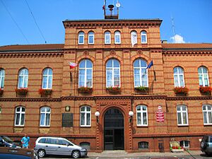
- Town Hall (Ratusz): This building was built in 1833. It was badly damaged during World War II but was rebuilt between 1950 and 1960.
- Piast Oak: This is a very old oak tree, estimated to be about 600 years old! It's a natural monument, meaning it's protected. It's about 3 km south of Rzepin, in the village of Liszki.
- Beaver's Path Nature Trail: This trail starts near the forest lodge in Nowy Młyn. It follows the Rzepia River where it meets the Ilanka River.
- Water Mill: Built in the early 1800s, this mill now uses an electric turbine to work.
Nature Around Rzepin
- Natural Monuments: Besides the "Piast Oak," there are other old trees, mostly oaks, in the Nowy Młyn forest area. There are also groups of Scots Pine trees. You can find Populus and Willow trees in town. A large glacial rock near Gajec is also a natural monument.
- Nature Reserves: The closest nature reserve is the Torfowiska Sułowskie Peat Bog Reserve. This area is part of the Natura 2000 program. It's home to a special plant called Aldrovanda vesiculosa.
- Ecological Sites: Many small ecological sites are found within the National Forests. These include places like 'Łąki' (Meadows), 'Wzdłuż Ilanki' (Along Ilanka), and 'Wokół Jeziora Popienko' (Around Popienko Lake), which is a home for the rare Bog Orchid.
Education in Rzepin
Rzepin has several schools:
- Jan Kochanowski Gymnasium
- Stanisław Staszic Secondary School
- Henryk Sienkiewicz Elementary School
- A Complex of Forest Schools in Starościn
Culture
The "Chrobry" Cinema is part of the Community Cultural Center in Rzepin.
Getting Around Rzepin
Roads
- A2 Motorway: This major highway connects Rzepin to cities like Poznań and Warsaw.
- National Road 92: This road also connects Rzepin to Poznań and Warsaw.
- Voivodship Road 134: Connects Rzepin to Urad and Ośno Lubuskie.
- Voivodship Road 139: Connects Rzepin to Górzyca and Kowalów.
Train Connections
Rzepin is an important train hub. You can travel by train from Rzepin to:
- East and West: Poznań, Warsaw, Frankfurt (Oder), and Berlin.
- North and South: Szczecin, Zielona Góra, and Wrocław.
Walking Trails
- Red Trail: Starts at Rzepin Railway Station and goes through Rzepinek, past the Piast Oak, and towards Krosno Odrzańskie.
- Blue Trail: Starts at Pliszka Railway Station and goes through Pliszka and Dębrznica towards Torzym.
- Green Trail: Starts at Gądków Wielki Railway Station and loops around Wielickie Lake.
- Yellow Trail: This is part of a long European walking route (E11). It goes from Słubice through places like Sułów and Ośno Lubuskie.
Bicycle Trails
 Red Trail: From Słubice through Gajec, Rzepin, Nowy Młyn, and towards Cybinka.
 Green Trail: From Gajec through Nowy Młyn and Maczków.
 Blue Trail: From Bobrówko through Pniów and Garbicz towards Torzym Railway Station.
 Green Trail (International R1): Part of an international route that goes through Ośno Lubuskie.
- There are also six shorter bike trails within the Rzepin area.
Famous People from Rzepin
- Ernst Wenck (1865–1929): A German sculptor and professor.
- Johannes Wolburg (1905–1976): A German geologist and paleontologist.
- Stanisław Kusiak (1912–1989): A priest.
- Marian Eckert (1932–2015): A historian and professor.
- Zbigniew Pusz (born 1949): A politician and businessman.
- Dariusz Muszer (born 1959): A Polish-German writer who lived in Rzepin.
Sister Cities
To learn about Rzepin's sister cities, see twin towns of Gmina Rzepin.
 | Dorothy Vaughan |
 | Charles Henry Turner |
 | Hildrus Poindexter |
 | Henry Cecil McBay |


