Saarlouis District facts for kids
Quick facts for kids
Saarlouis
|
|
|---|---|
 |
|
| Country | |
| State | Saarland |
| Capital | Saarlouis |
| Area | |
| • Total | 459.08 km2 (177.25 sq mi) |
| Population
(2002)
|
|
| • Total | 211,393 |
| • Density | 460.471/km2 (1,192.614/sq mi) |
| Time zone | UTC+1 (CET) |
| • Summer (DST) | UTC+2 (CEST) |
| Vehicle registration | SLS |
| Website | kreis-saarlouis.de |
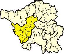
Saarlouis is a district in the middle of Saarland, Germany. Think of a district like a county or a region within a state. It's a cool place with a lot of history!
Contents
A Look Back in Time
For a long time, the Saarlouis area was part of the Holy Roman Empire. This was a huge group of lands in Central Europe.
After the Napoleonic Wars, the region became part of Prussia. Prussia was a powerful kingdom in Germany. In 1816, Prussia officially created the Saarlouis district. It was part of their Rhineland province.
From 1936 to 1945, the district had a different name: Saarlautern. The government at that time wanted to change the French-sounding name "Saarlouis" to a German one.
Where is Saarlouis?
The main river flowing through the Saarlouis district is the Saar. This river is important for the area's geography.
What's on the Coat of Arms?
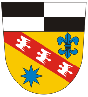
The coat of arms for Saarlouis district tells a story. The top part has a black-and-white checkerboard pattern. This comes from the coat of arms of the Hohenzollern family. They were the rulers of the German Empire. This part reminds us that the area was once directly under their rule.
The bottom part of the coat of arms shows symbols from the Duchy of Lorraine. Saarlouis was part of the Duchy of Lorraine from about 1100 to 1766.
- The star on the coat of arms stands for the French fortress of Saarlouis. The city of Saarlouis started as a fortress built in a star shape.
- The fleur-de-lis is a lily symbol. It comes from the coat of arms of the city of Saarlouis itself.
Towns and Municipalities
Here are the main towns and smaller communities in the Saarlouis district:
| Towns | Municipalities | |
|---|---|---|
|
|
|
 | Selma Burke |
 | Pauline Powell Burns |
 | Frederick J. Brown |
 | Robert Blackburn |


