
Saillon facts for kids
Quick facts for kids
Saillon
|
||
|---|---|---|
 |
||
|
||

Saillon
Location in Switzerland

Saillon
Location in Canton of Valais
|
||
| Country | Switzerland | |
| Canton | Valais | |
| District | Martigny | |
| Area | ||
| • Total | 13.74 km2 (5.31 sq mi) | |
| Elevation | 510 m (1,670 ft) | |
| Population
(Dec 2020 )
|
||
| • Total | 2,818 | |
| • Density | 205.09/km2 (531.19/sq mi) | |
| Postal code |
1913
|
|
| Surrounded by | Fully, Leytron, Riddes, Saxon | |
| Twin towns | Barbentane (France) | |

Saillon is a charming town located in the Martigny area of Valais, a canton in Switzerland. It's a small community with a rich history and beautiful surroundings.
Contents
A Look at Saillon's Past
Saillon was first mentioned in old records way back in 1052. At that time, it was known as castellum Psallionis. For a while, it was also called Schellon in German, but that name is not used anymore.
Where is Saillon?

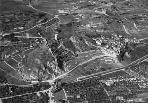
Saillon is located on the right side of the Rhône River. It includes the main village of Saillon and a small separate area called Euloi.
The town covers an area of about 13.7 square kilometers (5.3 square miles). A large part of this land, about 37.6%, is used for farming. Forests cover another 20.5% of the area. About 8.2% of the land has buildings and roads. Rivers and lakes make up 2.3%, and the remaining 31.1% is land that cannot be used for farming or building, like rocky areas.
Saillon's Coat of Arms
The official symbol, or coat of arms, for Saillon shows a black tower on a silver background.
Who Lives in Saillon?


Saillon has a population of about 2,079 people. Over the past ten years, the number of people living here has grown quite a bit.
Most people in Saillon speak French as their main language. Some also speak Portuguese or German.
In 2008, about half of the population was male and half was female. Many people living in Saillon were born there, or in the same canton of Valais.
Young people, aged 0 to 19, make up about 27.6% of the population. Adults aged 20 to 64 make up 58.5%, and seniors over 64 make up 13.9%.
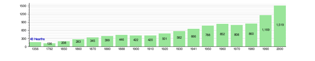
How Saillon's Population Has Grown
The chart below shows how the number of people living in Saillon has changed over many years. You can see how the population has grown from just a few hundred to over a thousand.
Important Historical Sites
Saillon is home to some very old and important buildings. The old Fortifications and the famous Bayard Tower are considered national heritage sites in Switzerland. The entire town of Saillon is part of the Inventory of Swiss Heritage Sites, which means it's a special place with a lot of history.
-
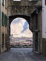
Fortifications
-
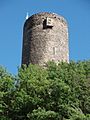
Bayard Tower


Saillon's Twin Town
Saillon has a special friendship with another town, called a "twin town." Its twin town is:
 Barbentane, which is in France.
How People Work in Saillon
In Saillon, people work in different types of jobs. Some work in the primary sector, which means jobs like farming. Others work in the secondary sector, which includes jobs in factories or construction. Many people also work in the tertiary sector, which covers jobs like sales, hotels, restaurants, and healthcare.
Many people who live in Saillon travel to other towns for work. Also, some people travel into Saillon to work there. Most people use a private car to get to work, while a smaller number use public transportation.
Religion in Saillon
Most people in Saillon are Roman Catholic. A smaller number belong to the Swiss Reformed Church or other Christian churches. There are also some people who are Islamic or Buddhist. Some people do not belong to any church.
Learning and Education
Many adults in Saillon have completed high school, and some have gone on to higher education at a university or a specialized college.
Saillon has a local library called Bibliothèque communale et scolaire. It has thousands of books and other media that people can borrow. The library is open many days a year for the community.
See also
 In Spanish: Saillon para niños
