
Saint-Jean-d'Angély facts for kids
Quick facts for kids
Saint-Jean-d'Angély
|
||
|---|---|---|

Historic centre of Saint-Jean-d'Angély
|
||
|
||

Saint-Jean-d'Angély
Location in France

Saint-Jean-d'Angély
Location in Nouvelle-Aquitaine
|
||
| Country | France | |
| Region | Nouvelle-Aquitaine | |
| Department | Charente-Maritime | |
| Arrondissement | Saint-Jean-d'Angély | |
| Canton | Saint-Jean-d'Angély | |
| Intercommunality | Vals de Saintonge | |
| Area
1
|
18.78 km2 (7.25 sq mi) | |
| Population
(2014)
|
7,123 | |
| • Density | 379.29/km2 (982.3/sq mi) | |
| Time zone | UTC+01:00 (CET) | |
| • Summer (DST) | UTC+02:00 (CEST) | |
| INSEE/Postal code |
17347 /17400
|
|
| Elevation | 8–76 m (26–249 ft) (avg. 42 m or 138 ft) |
|
| Website | www.angely.net | |
| 1 French Land Register data, which excludes lakes, ponds, glaciers > 1 km2 (0.386 sq mi or 247 acres) and river estuaries. | ||
.svg)
Saint-Jean-d'Angély is a town in southwestern France. It is part of the Charente-Maritime area, which is like a county. This town is also a subprefecture, meaning it's an important administrative center. It is located in the Nouvelle-Aquitaine region of France.
The town's history began a long time ago with the Abbey of Saint-Jean-d'Angély.
Contents
Where is Saint-Jean-d'Angély Located?
Saint-Jean-d'Angély is found in the northeast part of the Charente-Maritime area. It sits along the Boutonne river. This river flows into the larger Charente river.
The town covers an area of about 18.8 km2 (7.3 sq mi). Its average height above sea level is 42 m (138 ft). At the town hall, the height is about 20 m (66 ft).
Distances to Other Cities
Here's how far Saint-Jean-d'Angély is from some other big cities:
| Bordeaux | Toulouse | Montpellier | Lyon | Nantes | Paris | Marseille |
|---|---|---|---|---|---|---|
| 148 km (92 mi) | 384 km (239 mi) | 622 km (386 mi) | 580 km (360 mi) | 211 km (131 mi) | 447 km (278 mi) | 787 km (489 mi) |
Neighboring Towns
Saint-Jean-d'Angély is surrounded by several other towns. You can see them on the map below:

The towns around Saint-Jean-d'Angély are:
 |
La Vergne | Saint-Denis-du-Pin | Courcelles | |
| Ternant | Saint-Julien-de-l'Escap | |||
| Mazeray | Asnières-la-Giraud |
What is the Climate Like?
Saint-Jean-d'Angély has an oceanic climate. This means it has mild summers and no dry season. It's classified as Cfb in the Köppen climate classification system.
How Many People Live Here?
The people who live in Saint-Jean-d'Angély are called Angériens (for men) and Angériennes (for women) in French.
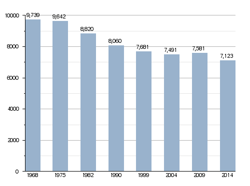
In 2014, the town had 7,123 people living there. This means there were about 379 people for every square kilometer.
Population Changes Over Time
The chart below shows how the number of people living in Saint-Jean-d'Angély has changed over the years.
Evolution of the population in Saint-Jean-d'Angély
How is Saint-Jean-d'Angély Governed?
Saint-Jean-d'Angély is a subprefecture of the Charente-Maritime area. It is the main town of the arrondissement (a type of district) of Saint-Jean-d'Angély. It is also the main town for the canton of Saint-Jean-d'Angély.
The town is part of a group of towns called Vals de Saintonge. This group works together on different projects.
Sister Cities Around the World
Saint-Jean-d'Angély has special partnerships with other cities in different countries. These are called "twinned" or "sister" cities:
 Saint-Sulpice, Quebec, Canada
 New Iberia, Louisiana, United States
Gallery


Related Pages
See also
 In Spanish: Saint-Jean-d'Angély para niños
