
Saint Arnaud, New Zealand facts for kids
Quick facts for kids
Saint Arnaud
|
|
|---|---|

View over Lake Rotoiti and St Arnaud
|
|
| Country | New Zealand |
| Territorial authority | Tasman |
| Ward | Lakes-Murchison Ward |
| Electorates |
|
| Area | |
| • Total | 6.28 km2 (2.42 sq mi) |
| Elevation | 650 m (2,130 ft) |
| Population
(June 2023)
|
|
| • Total | 150 |
| • Density | 23.9/km2 (61.9/sq mi) |
| Time zone | UTC+12 (NZST) |
| • Summer (DST) | UTC+13 (NZDT) |
| Postcode(s) |
7072
|
| Area code | 03 |
Saint Arnaud is a small mountain village in the Tasman region of New Zealand. It is located on the South Island, west of the Saint Arnaud Range mountains. The village is about 90 kilometres southwest of Nelson. It sits at the northern end of Lake Rotoiti.
Contents
Why Was Saint Arnaud's Name Changed?
The village was first called Rotoiti until 1921. It was renamed by the Department of Lands and Survey. This was done to avoid confusion with other places that had the same name.
Records show that from 1921 to 1951, both names were used. People living there and government groups used both names. A letter from 1950 explained the problem. Mail for Lake Rotoiti in the Nelson area often went to Lake Rotoiti near Rotorua.
Because of this mix-up, the name was changed to Saint Arnaud. However, the new name was not officially approved until July 19, 1951. Some local people did not like this change. A petition was sent in 1950 to stop it. Even today, some residents still use Lake Rotoiti as their address.
In 2007, there was a plan to change the name back to Rotoiti. Another idea was to use both names, which is common in New Zealand. A survey showed that about half of the residents wanted the original name back. But the plan did not go through.
The name Saint Arnaud can be tricky to say. The official way to say it is like the French name, which sounds like "ah-noh." But many locals say it differently, with the end sounding like "ah-nəd."
Who Lives in Saint Arnaud?
Saint Arnaud is a small rural village. It covers an area of about 6.28 square kilometres. In 2018, about 111 people lived there. This means there were about 17.7 people per square kilometre.

The population of Saint Arnaud has grown over the years. In 2006, there were 78 people. By 2013, it grew to 105 people. In 2018, the population reached 111.
There were 54 households in 2018. There were 60 males and 54 females. The average age of people living there was 54.5 years. This is older than the national average of 37.4 years.
Most people in Saint Arnaud are of European descent (89.2%). Some are Māori (5.4%). A small number are Asian (2.7%) or other ethnicities.
When asked about religion, most people (67.6%) said they had no religion. About 18.9% were Christian. A small number (2.7%) followed other religions.
Many adults in Saint Arnaud have a good education. About 29.4% have a bachelor's degree or higher. The average income was $35,000. Most adults (50%) worked full-time.
What Can You Do in Saint Arnaud?
Saint Arnaud is a popular spot for tourists. It is especially loved by people who enjoy tramping (hiking) and skiing. The village has a few useful places for visitors.
You can find a village store with postal services. There is also a petrol station and a cafe-restaurant. For places to stay, there are camping facilities, motels, and chalets. The Travers-Sabine Lodge is a youth hostel for trampers.
A water taxi service operates from a jetty at the northern end of Lake Rotoiti. There are also two campsites nearby, one at Kerr Bay and another at West Bay. A daily bus service connects Saint Arnaud to other towns. These include Nelson, Murchison, Greymouth, Blenheim, Westport, and Picton.
The Royal New Zealand Air Force has a training base nearby called Dip Flat.
Exploring Nelson Lakes National Park
Saint Arnaud is a gateway to the Nelson Lakes National Park. The park has a Department of Conservation (DOC) Visitor Centre. Here, you can learn about the park's wildlife and how it is managed. The staff can give you advice on exploring the area.
There are many walking paths and nature trails. They are suitable for all skill levels. The DOC maintains these trails.
Saint Arnaud is the start of the challenging 80-kilometre Travers - Sabine tramping circuit. This trail follows the Travers River valley. It goes over the Travers Saddle, a high mountain pass. Then it goes down the Sabine River valley to Lake Rotoroa.
From Lake Rotoroa, hikers can return to Saint Arnaud. They can cross a low pass to Lake Rotoiti via the Speargrass Track. Or they can take a higher route over Mount Angelus. Another option is a water taxi from the DOC Sabine Hut on Lake Rotoroa to the northern end of the lake.
In winter, people enjoy snow sports at Rainbow Skifield. This ski area is on the eastern side of the Saint Arnaud Range. Other fun activities in the area include fishing, hunting, kayaking, sailing small boats, and gliding.
How to Get Around Saint Arnaud
State Highway 63 runs through Saint Arnaud. This highway connects the town to Blenheim and the Marlborough area in the east. It also links to Murchison and the West Coast in the west.
The Korere Tophouse Road leaves State Highway 63 a few kilometres east of Saint Arnaud. This road is the most direct way to get to Richmond and Nelson.
Network Tasman manages the electricity supply in Saint Arnaud. Electricity comes from Transpower's national grid. The power station is about 15 kilometres north of the town.
The Tasman District Council handles stormwater and wastewater systems in Saint Arnaud. However, individual homes need to set up their own fresh water supply.
Learning in Saint Arnaud
Lake Rotoiti School is the only school in Saint Arnaud. It teaches students from ages 5 to 12 (years 1 to 8). The closest schools for older students are Tapawera Area School and Murchison Area School. They are about 54 km and 59 km away by road.
What is Saint Arnaud's Climate Like?
Saint Arnaud has a temperate climate. This means it has mild temperatures. Even though it is about 650 metres high, it rarely gets much snow. This is because it is close to the Cook Strait, which brings warmer ocean air. Other towns at similar heights, like Lake Tekapo, often get more snow.
| Climate data for St Arnaud (1980–2012 normals, extremes 1965–2012) | |||||||||||||
|---|---|---|---|---|---|---|---|---|---|---|---|---|---|
| Month | Jan | Feb | Mar | Apr | May | Jun | Jul | Aug | Sep | Oct | Nov | Dec | Year |
| Record high °C (°F) | 31.4 (88.5) |
31.3 (88.3) |
29.1 (84.4) |
23.0 (73.4) |
20.0 (68.0) |
16.4 (61.5) |
13.9 (57.0) |
17.5 (63.5) |
24.0 (75.2) |
25.0 (77.0) |
29.9 (85.8) |
30.4 (86.7) |
31.4 (88.5) |
| Mean maximum °C (°F) | 27.7 (81.9) |
26.9 (80.4) |
24.1 (75.4) |
20.2 (68.4) |
16.7 (62.1) |
13.2 (55.8) |
12.2 (54.0) |
14.3 (57.7) |
17.4 (63.3) |
20.9 (69.6) |
23.8 (74.8) |
25.4 (77.7) |
28.4 (83.1) |
| Mean daily maximum °C (°F) | 21.1 (70.0) |
20.9 (69.6) |
18.6 (65.5) |
15.4 (59.7) |
11.9 (53.4) |
9.0 (48.2) |
8.6 (47.5) |
10.0 (50.0) |
12.1 (53.8) |
14.4 (57.9) |
16.8 (62.2) |
18.8 (65.8) |
14.8 (58.6) |
| Daily mean °C (°F) | 14.7 (58.5) |
14.7 (58.5) |
12.7 (54.9) |
9.7 (49.5) |
6.9 (44.4) |
4.1 (39.4) |
3.5 (38.3) |
4.7 (40.5) |
6.8 (44.2) |
8.9 (48.0) |
11.0 (51.8) |
13.2 (55.8) |
9.2 (48.7) |
| Mean daily minimum °C (°F) | 8.5 (47.3) |
8.5 (47.3) |
6.8 (44.2) |
4.0 (39.2) |
1.8 (35.2) |
−0.8 (30.6) |
−1.6 (29.1) |
−0.5 (31.1) |
1.4 (34.5) |
3.5 (38.3) |
5.2 (41.4) |
7.5 (45.5) |
3.7 (38.6) |
| Mean minimum °C (°F) | 2.0 (35.6) |
2.4 (36.3) |
−0.4 (31.3) |
−2.5 (27.5) |
−4.4 (24.1) |
−6.3 (20.7) |
−6.9 (19.6) |
−6.6 (20.1) |
−5.2 (22.6) |
−3.1 (26.4) |
−0.9 (30.4) |
0.8 (33.4) |
−7.6 (18.3) |
| Record low °C (°F) | −0.8 (30.6) |
−1.6 (29.1) |
−3.6 (25.5) |
−6.5 (20.3) |
−7.2 (19.0) |
−10.6 (12.9) |
−9.5 (14.9) |
−10.1 (13.8) |
−7.7 (18.1) |
−6.1 (21.0) |
−3.6 (25.5) |
−3.2 (26.2) |
−10.6 (12.9) |
| Average rainfall mm (inches) | 122.9 (4.84) |
105.3 (4.15) |
110.0 (4.33) |
111.1 (4.37) |
126.4 (4.98) |
143.1 (5.63) |
117.1 (4.61) |
121.5 (4.78) |
146.1 (5.75) |
161.4 (6.35) |
127.7 (5.03) |
161.2 (6.35) |
1,553.8 (61.17) |
| Source 1: NIWA | |||||||||||||
| Source 2: Metservice | |||||||||||||
The Skifield is at a higher elevation. Its climate is different:
| Climate data for Rainbow Ski Area, 1,540 m | |||||||||||||
|---|---|---|---|---|---|---|---|---|---|---|---|---|---|
| Month | Jan | Feb | Mar | Apr | May | Jun | Jul | Aug | Sep | Oct | Nov | Dec | Year |
| Mean daily maximum °C (°F) | 14.4 (57.9) |
14.5 (58.1) |
12.8 (55.0) |
10.0 (50.0) |
7.0 (44.6) |
4.5 (40.1) |
3.8 (38.8) |
4.5 (40.1) |
6.7 (44.1) |
8.6 (47.5) |
10.6 (51.1) |
12.7 (54.9) |
9.2 (48.6) |
| Daily mean °C (°F) | 8.8 (47.8) |
8.9 (48.0) |
7.4 (45.3) |
4.8 (40.6) |
1.9 (35.4) |
−0.5 (31.1) |
−1.2 (29.8) |
−0.4 (31.3) |
1.7 (35.1) |
3.5 (38.3) |
5.3 (41.5) |
7.3 (45.1) |
4.0 (39.2) |
| Mean daily minimum °C (°F) | 3.2 (37.8) |
3.3 (37.9) |
2.1 (35.8) |
−0.4 (31.3) |
−2.3 (27.9) |
−5.4 (22.3) |
−6.2 (20.8) |
−5.2 (22.6) |
−3.3 (26.1) |
−1.5 (29.3) |
0.1 (32.2) |
2.0 (35.6) |
−1.1 (30.0) |
| Average rainfall mm (inches) | 131 (5.2) |
94 (3.7) |
113 (4.4) |
131 (5.2) |
139 (5.5) |
125 (4.9) |
127 (5.0) |
120 (4.7) |
142 (5.6) |
159 (6.3) |
148 (5.8) |
143 (5.6) |
1,572 (61.9) |
| Source: Climate-data.org, estimated from the Saint Arnaud weather station. | |||||||||||||
Images for kids
-
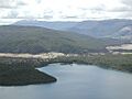
View over Lake Rotoiti and St Arnaud
-
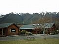
Youth hostel cottages, the Saint Arnaud Range behind.
