Sainte-Anne River (Beaupré) facts for kids
Quick facts for kids Sainte-Anne River |
|
|---|---|

Sainte-Anne (Beaupré) River
|
|
| Other name(s) | Rivière Sainte-Anne-du-Nord |
| Country | Canada |
| Province | Quebec |
| Region | Capitale-Nationale |
| Regional County Municipality | Charlevoix Regional County Municipality and La Côte-de-Beaupré Regional County Municipality |
| Municipalities | Lac-Pikauba TNO, Baie-Saint-Paul, Saint-Tite-des-Caps, Saint-Ferréol-les-Neiges et Beaupré |
| Physical characteristics | |
| Main source | Lac Sainte-Anne-du-Nord Lac-Pikauba 914 m (2,999 ft) 47°41′08″N 70°44′11″W / 47.685499°N 70.736332°W |
| River mouth | Saint Lawrence River Beaupré, MRC La Côte-de-Beaupré Regional County Municipality 6 m (20 ft) 47°02′24″N 70°53′00″W / 47.040051°N 70.883446°W |
| Length | 97 km (60 mi) |
| Basin features | |
| Basin size | 1,077 km2 (416 sq mi) |
| Tributaries |
|

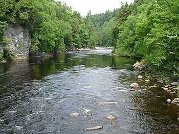
The Sainte-Anne River is a beautiful river in Quebec, Canada. It flows into the Saint Lawrence River near the town of Beaupré. This river is special because it passes through the amazing Canyon Sainte-Anne before reaching the Saint Lawrence.
Contents
Exploring the Sainte-Anne River
The Sainte-Anne River is located in the Capitale-Nationale region of Quebec. It stretches for about 72.2 kilometers (45 miles). The river's basin, which is the area of land that drains into it, covers 1,077 square kilometers (416 square miles). On average, 26 cubic meters of water flow through it every second.
The river begins at Lac de la Tour, which is a lake inside Grands-Jardins National Park. From there, it flows south until it reaches Beaupré. This is where it joins the Saint Lawrence River, right across from Île d'Orléans. This spot is about 35 kilometers (22 miles) northeast of Quebec City.
Waterfalls and Canyons
In the area of Saint-Ferréol-les-Neiges, you can find the Seven Chutes. These are a series of impressive waterfalls, some as high as 128 meters (420 feet)!
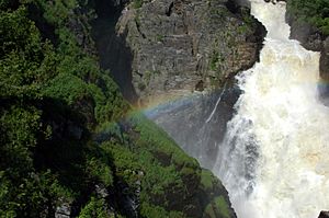
After the Seven Chutes, the river flows through the Canyon Sainte-Anne. This is a deep gorge that is about 10 kilometers (6 miles) long. At the end of the canyon, near Saint-Joachim, there's another stunning waterfall called the Sainte-Anne waterfall, which is 74 meters (243 feet) high.
The River's Journey: Upper Course
The Sainte-Anne River starts its journey from Lac de la Tour. For the first 9 kilometers (5.6 miles), it flows southeast, then east. It crosses a small lake and Quebec Route 381. It then goes through Lake at Lizé and Lake Perrault. Finally, it flows into Lac Sainte-Anne du Nord, which is 748 meters (2,454 feet) above sea level.
After Lac Sainte-Anne du Nord, the river continues for another 9.3 kilometers (5.8 miles). It flows southwest through a deep valley, picking up water from other lakes like Pointu Lake and Lac du Versant. It then turns south, collecting water from Lac Turgeon. The river then flows southeast, passing through Lake Arthabaska and Pemmican Lake. It also goes past the Wabano Dam.
The river then flows southeast in a mostly straight line, crossing Lac Troué and Lac Long. It passes the Barrage du Lac-Long and collects water from Buies and Théodule lakes. It then curves south through a deep valley, picking up water from Chaudière and Beaupré lakes. Further south, it collects the Courganne stream and the Petit Lac Double stream. The upper course ends where it meets the rivière Savane du Nord.
The River's Journey: Middle Course
The middle part of the Sainte-Anne River stretches for about 26.4 kilometers (16.4 miles). It flows southeast through a deep valley, collecting water from North-East Lake and Le Big Creek. It continues southeast, then east, making a bend where another stream joins it.
The river then flows south, going through eight sets of rapids, until it meets the Petite rivière Savane. It continues south, forming a large "S" shape and crossing five more sets of rapids. It also picks up water from an unnamed lake.
Further along, the river flows south, crossing several more rapids. It collects the Beaumier stream and flows around two islands. This section ends where the Brûlée River joins it.
After the Brûlée River, the Sainte-Anne River flows for another 16.5 kilometers (10.3 miles). It forms a large "S" shape, flowing around two more islands. It then meets the Sables Mountain Creek. The river then flows east, then south, then southeast, crossing more rapids. It meets the rivière du Mont Saint-Étienne and then flows under the Quebec Route 360 bridge.
The river continues southeast, south, and then southeast again, collecting water from another stream. It flows in a fairly straight line until it meets the Lombrette River. Finally, it flows south, bending west, to the Sept-Chutes dam. It then flows southwest, going over the seven falls and more rapids, until it meets the rivière des Roches.
The River's Journey: Lower Course
The last part of the Sainte-Anne River is about 11 kilometers (6.8 miles) long. It flows south through a deep valley, crossing many rapids. It makes a hook to the east and goes through the Bassin de l'Érablière, where it gets water from another stream. It then makes a large curve to the west, reaching the Sainte-Anne Falls. Here, the rivière du Moulin joins it.
The river then flows south, making a large "S" shape to go around the mountains. It crosses two more sets of rapids and collects water from the Jean-Larose River. It then reaches a dam. The river continues southeast, curving northeast, and crosses under the Quebec Route 138 bridge.
Finally, the river flows east, then south, going around the town of Beaupré. It passes under a railway bridge. The last 0.5 kilometers (0.3 miles) flow southeast through a bay with a marina, where it finally empties into the Saint Lawrence River.
The mouth of the Sainte-Anne River is in Beaupré, across from the northern tip of Île d'Orléans. This spot is about 35 kilometers (22 miles) northeast of downtown Quebec City. It's also about 26 kilometers (16 miles) northeast of the bridge that connects Île d'Orléans to L'Ange-Gardien. The river's mouth is just 2.5 kilometers (1.6 miles) northwest of Île d'Orléans, across the Chenal de l'Île d'Orléans (which means "Channel of Île d'Orléans").
River Name: Toponymy
The name "Rivière Sainte-Anne" was officially recognized on April 4, 1982. This was done by the Commission de toponymie du Québec, which is like a special group that names places in Quebec.
Power from the River: Hydroelectric Plants
The Sainte-Anne River is used to create electricity! There are two hydroelectric power plants on the river.
Sept-Chutes Hydroelectric Plant
The Sept-Chutes power plant uses the river's flow to make electricity. It belongs to Hydro-Québec, a big electricity company. This plant was built in 1916 and was updated in 1999. It has four turbines that can produce a total of 22 megawatts of power. The plant uses the river's drop of 124.97 meters (410 feet) to generate power. You can even visit this power station!
Hydro-Canyon Hydroelectric Plant
In 2016, another hydroelectric power plant started working. It's called the Hydro-Canyon Saint-Joachim plant and is located about 300 meters (984 feet) upstream from Canyon Sainte-Anne.
This power plant was designed to fit in with the natural environment and the tourist attractions around Canyon Sainte-Anne. It helps to use the power of the Sainte-Anne waterfall to create up to 23.2 megawatts of electricity.
The plant includes several parts:
- A special wall called a weir to keep the river level steady.
- A spillway to let extra water flow out.
- A water intake where water enters the plant.
- A gallery (tunnel) for the water.
- The power plant building with all the equipment.
- A substation and power lines to connect to the main electricity network.
Fun on the River: Sports
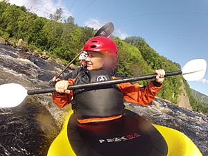
Since 1966, the Sainte-Anne River has been a popular spot for kayaking. There's a club and school called Kayak Côte-de-Beaupré that uses the river. A part of the Sainte-Anne River, between the Sept-Chutes and Hydro-Canyon power plants, is even rated "5 stars" by the Quebec river guide. This means it's a great place for experienced kayakers!
Images for kids
 | William M. Jackson |
 | Juan E. Gilbert |
 | Neil deGrasse Tyson |


