Saline County, Arkansas facts for kids
Quick facts for kids
Saline County
|
|
|---|---|

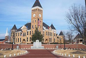
Saline County Courthouse in Benton
|
|

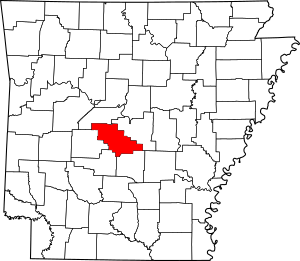
Location within the U.S. state of Arkansas
|
|
 Arkansas's location within the U.S. |
|
| Country | |
| State | |
| Founded | November 2, 1835 |
| Seat | Benton |
| Largest city | Benton |
| Area | |
| • Total | 730 sq mi (1,900 km2) |
| • Land | 724 sq mi (1,880 km2) |
| • Water | 6.9 sq mi (18 km2) 0.9%% |
| Population
(2020)
|
|
| • Total | 123,416 |
| • Density | 169.1/sq mi (65.3/km2) |
| Time zone | UTC−6 (Central) |
| • Summer (DST) | UTC−5 (CDT) |
| Congressional district | 2nd |
Saline County is a county in the state of Arkansas. In 2020, about 123,416 people lived here. The main city and county seat is Benton.
Saline County was created on November 2, 1835. It got its name from the salty water springs in the area. For a long time, until 2014, it was a "dry county." This meant that selling alcohol was not allowed. Saline County is part of the Central Arkansas region.
Contents
Geography of Saline County
Saline County covers a total area of about 730 square miles. Most of this is land, about 724 square miles. The rest, about 6.9 square miles, is water.
Main Roads in Saline County
Many important roads pass through Saline County. These roads help people travel and transport goods.
 Interstate 30
 Interstate 30 Business Loop
 Interstate 530
 U.S. Highway 65
 U.S. Highway 67
 U.S. Highway 70
 U.S. Highway 167
 Highway 5
 Highway 9
 Highway 35
Neighboring Counties
Saline County shares its borders with several other counties:
- Perry County (to the northwest)
- Pulaski County (to the northeast)
- Grant County (to the southeast)
- Hot Spring County (to the southwest)
- Garland County (to the west)
Protected Natural Areas
Part of the Ouachita National Forest is located within Saline County. This is a large area of protected land.
People of Saline County
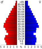
The number of people living in Saline County has grown a lot over the years.
| Historical population | |||
|---|---|---|---|
| Census | Pop. | %± | |
| 1840 | 2,061 | — | |
| 1850 | 3,903 | 89.4% | |
| 1860 | 6,640 | 70.1% | |
| 1870 | 3,911 | −41.1% | |
| 1880 | 8,953 | 128.9% | |
| 1890 | 11,311 | 26.3% | |
| 1900 | 13,122 | 16.0% | |
| 1910 | 16,657 | 26.9% | |
| 1920 | 16,781 | 0.7% | |
| 1930 | 15,660 | −6.7% | |
| 1940 | 19,163 | 22.4% | |
| 1950 | 23,816 | 24.3% | |
| 1960 | 28,956 | 21.6% | |
| 1970 | 36,107 | 24.7% | |
| 1980 | 53,161 | 47.2% | |
| 1990 | 64,183 | 20.7% | |
| 2000 | 83,529 | 30.1% | |
| 2010 | 107,118 | 28.2% | |
| 2020 | 123,416 | 15.2% | |
| 2023 (est.) | 129,574 | 21.0% | |
| U.S. Decennial Census 1790–1960 1900–1990 1990–2000 2010 |
|||
In 2020, there were 123,416 people living in Saline County. These people made up 45,455 households. About 31,395 of these were families.
2020 Census Information
The 2020 census looked at the different groups of people living in Saline County.
| Race | Number | Percentage |
|---|---|---|
| White (non-Hispanic) | 96,745 | 78.39% |
| Black or African American (non-Hispanic) | 10,351 | 8.39% |
| Native American | 522 | 0.42% |
| Asian | 1,453 | 1.18% |
| Pacific Islander | 70 | 0.06% |
| Other/Mixed | 5,768 | 4.67% |
| Hispanic or Latino | 8,507 | 6.89% |
Local News
The newspaper and online news for the area is called The Saline Courier.
Communities in Saline County
Saline County has many different towns and cities.
Cities
Town
Census-designated places
These are areas that are like towns but are not officially incorporated as cities.
Unincorporated communities
These are smaller places that are not part of any city or town.
Townships
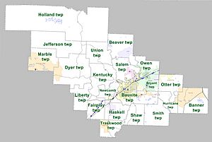
Townships are smaller areas within a county, often used for local government or land division. Townships in Arkansas are the divisions of a county. Each township includes unincorporated areas; some may have incorporated cities or towns within part of their boundaries. Arkansas townships have limited purposes in modern times. However, the United States Census does list Arkansas population based on townships (sometimes referred to as "county subdivisions" or "minor civil divisions"). Townships are also of value for historical purposes in terms of genealogical research. Each town or city is within one or more townships in an Arkansas county based on census maps and publications. The townships of Saline County are listed below; listed in parentheses are the cities, towns, and/or census-designated places that are fully or partially inside the township.
- Banner (contains most of East End)
- Bauxite (contains Bauxite, most of Benton)
- Beaver (contains Avilla, part of Bryant)
- Bryant (contains most of Alexander and Bryant, small parts of Benton and Shannon Hills)
- Dyer (contains part of Hot Springs Village)
- Fairplay
- Haskell (contains Haskell)
- Holland
- Hurricane (contains small part of East End)
- Jefferson
- Kentucky
- Liberty
- Marble (contains part of Hot Springs Village)
- Newcomb
- Otter (contains most of Shannon Hills, small parts of Alexander and East End)
- Owen (contains some of Bryant, small part of Alexander)
- Salem (contains Salem, small part of Bryant)
- Shaw
- Smith
- Traskwood (contains Traskwood)
- Union
Education in Saline County
Many school districts serve the students of Saline County.
- Bauxite School District
- Benton School District
- Bryant Public Schools
- Fountain Lake School District
- Glen Rose School District
- Harmony Grove School District
- Jessieville School District
- Pulaski County Special School District
- Sheridan School District
One school district that used to exist was the Paron School District. On July 1, 2004, it joined with the Bryant School District.
See also
 In Spanish: Condado de Saline (Arkansas) para niños


