
San Andres Formation, United States facts for kids
Quick facts for kids San Andres FormationStratigraphic range: Leonardian |
|
|---|---|

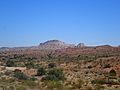
San Andres Formation caps Sierra de la Cruz northeast of Socorro, New Mexico, USA
|
|
| Type | Formation |
| Sub-units | Bonney Canyon & Fourmile Draw Members |
| Underlies | Grayburg Formation |
| Overlies | Glorieta & Yeso Formations |
| Thickness | 400 m (1,300 ft) |
| Lithology | |
| Primary | Limestone |
| Other | Dolomite, sandstone |
| Location | |
| Coordinates | 33°14′10″N 106°45′36″W / 33.236°N 106.760°W |
| Approximate paleocoordinates | 4°24′N 33°30′W / 4.4°N 33.5°W |
| Region | Texas New Mexico |
| Country | |
| Extent | San Juan Basin (subsurface) San Andres, Zuni & Sangre de Cristo Mountains (outcrop) |
| Type section | |
| Named for | San Andres Mountains |
| Named by | W.T. Lee |
| Year defined | 1909 |
The San Andres Formation is a special type of rock layer. It is found in the states of New Mexico and Texas in the USA. This rock layer holds fossils from a time called the late Leonardian Age. This age was part of the Permian Period, which was a very long time ago!
This rock formation is the most common Paleozoic rock layer you can see in New Mexico. It stretches for about 80 to 110 kilometers (50 to 68 miles). You can find it from west Texas all the way to central New Mexico. It also appears in the Zuni Mountains and Sangre de Cristo Mountains. Deep underground, it is also found in the San Juan Basin and eastern New Mexico.
Contents
What is the San Andres Formation Made Of?
This rock formation is mostly made of thick limestone. Limestone is a type of rock that often forms in oceans. The limestone in this formation sometimes has chert (a hard, glassy rock) in it. It does not always have many fossils, but in some places, you can find a lot of them. The San Andres Formation can be up to 400 meters (1,300 feet) thick. That's taller than many skyscrapers!
The San Andres Formation connects to other rock layers below it. These are the Glorieta Sandstone or the Yeso Group. Sometimes, the bottom part of the San Andres Formation has a lot of limestone and only a little sandstone. This part is called the Rio Bonito Member. Other times, the bottom part has mostly sandstone and less limestone. This part is then called the Glorieta Sandstone.
This change from sandy layers to ocean layers shows a big event. It was a time when the ocean levels rose and covered more land. This event happened in the late Leonardian Age. It was the last time the ocean reached northern New Mexico for about 150 million years!
The San Andres Formation also has other parts, called members. The Bonney Canyon Member is a thinner section of limestone. It sometimes has gypsum beds, which are soft mineral layers. The upper part is the Fourmile Draw Member. This part is mostly ocean carbonates (rocks made from shells and other sea life). As you go north, the entire San Andres Formation tends to have more dolomite. Dolomite is a rock similar to limestone.
Above the San Andres Formation, you will find the Grayburg Formation. If the Grayburg Formation is not there, then you might find much younger rocks from the Triassic Period on top.
Ancient Life: Fossils Found Here
The San Andres Formation contains fossils of different sea creatures. These include:
- The snail Euomphalus
- The tusk shells Plagioglypia canna and Dentalium mexicanam
- The bivalve Aviculipinna (a type of clam-like creature)
These fossils help scientists understand what life was like millions of years ago in the ancient oceans.
How Scientists Studied This Formation
Scientists have been studying the San Andres Formation for a long time.
- In 1900, a scientist named Herrick first noticed these rock layers. He saw they were above another group of rocks called the Manzano Group.
- In 1909, W.H. Lee thought these rocks were from a different time, the Pennsylvanian Period. He added them to the Manzano Group. He named the "San Andres Formation" after the San Andres Mountains.
- Later, in 1920, another scientist named Boese found out that the upper Manzano Group was actually from the Permian Period. So, the Manzano Group name was no longer used. The San Andres Formation was then correctly placed in the late Permian Period.
- In 1922, N.H. Darton noticed that the Yeso Formation and San Andres Formation looked very similar in some places. He made them both smaller parts (members) of a new formation he called the Chupadera Formation.
- By 1937, the San Andres Formation was known as an important rock layer. It was found both on the surface and deep underground in New Mexico and west Texas.
- In 1942, P.B. King suggested that the Chupadera Formation name should be dropped. He wanted the San Andres to be a main formation again.
- In 1943, Needham and Bates officially described a specific location for the San Andres Formation. They also separated the Glorieta Sandstone from it.
- Finally, in 1971, V.C. Kelley divided the San Andres Formation into the different members we know today.
Images for kids
-
San Andres Formation caps Sierra de la Cruz northeast of Socorro, New Mexico, USA
