
San Rafael, Veracruz facts for kids
Quick facts for kids
San Rafael Municipality
|
|
|---|---|

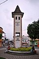
French style clock tower at entrance of municipal seat
|
|

San Rafael Municipality
Location in Mexico
|
|
| Country | |
| State | Veracruz |
| Founded | 19th century |
| Municipal Status | 2004 |
| Area | |
| • Municipality | 106.11 km2 (40.97 sq mi) |
| Population
(2005)Municipality
|
|
| • Municipality | 29,277 |
| • Seat | 6,515 |
| • | 4,620 |
| Time zone | UTC-6 (Central (US Central)) |
| • Summer (DST) | UTC-5 (Central) |
| Postal code (of seat) |
93620
|
| Website | Web site |
San Rafael Municipality is a municipality in the Mexican state of Veracruz. The main town and government center is San Rafael, Veracruz.
The economy here mainly relies on farming and raising livestock. Farmers grow bananas, limes, vanilla, and other crops. There's also a small tourism industry, thanks to the area's unique history. In the 1800s, many settlers came from eastern France. Because of this, a special local building style developed. It's sometimes called the casas de las riberas del río Nautla, meaning "riverside houses of the Nautla River".
Contents
Exploring San Rafael Town
The town of San Rafael was started by French immigrants in the early 1800s. These French families first settled in Jicaltepec, across the Bobos River. However, a local landowner named Rafael Martínez de la Torre offered them land on this side too.
You can still see French influence today. Some businesses have French-style names. Stores sell a European-style bread called "pan de agua." The town's entrance has a special area called Plaza del Reloj (Clock Square). Its large clock tower is new but built in a French style.
San Rafael Museum
The San Rafael Museum is right in front of the Clock Square. It tells the story of San Rafael's French past. Inside, you'll find old tools, kitchen items, and photos from the immigrants. There's also a room with ancient artifacts found in the region.
Local Celebrations
The municipality celebrates the founding of the French colony every year on July 14. Other fun local events include a summer carnival and a banana festival. The banana festival happens during Holy Week.
Historic Roads and Homes
On the road to Poza Rica just outside town, there's a statue of Don Quixote. This marks the old Camino Real road. You can still see houses there with their original roof tiles. More old houses are found on another road called "Mentidero." Many descendants of the first immigrants still live in these homes.
One famous house is Casa Stivalet. The Stivalet family grows fruit, makes fruit liquors, and preserves. The descendants of these immigrants still make homemade cheese and "pan de agua." Much of the food served in the area has a French touch.
Maison Couturier: A Special Place
Just outside San Rafael town is the Maison Couturier. It's a hotel and resort that calls itself a "pension agrícola," which means a "farm stay." Carlos Couturier, who designed other hotels in Mexico City, created this unique place.
The property was once a citrus farm owned by the Couturier family from Haute-Savoie in the 1800s. The main building keeps its French style but has modern updates. The restaurants serve French food, and many signs are in French. The hotel has nine rooms, each with a private terrace and antique furniture. The property is still a working lime plantation. It even has its own Cessna 206 airplane to bring guests from Mexico City or Puebla to its private airstrip. Other features include massages, a private chapel, a pool, French movies, and tours to local ancient sites.
San Rafael Municipality: Beyond the Town

The town of San Rafael serves as the government center for many other communities. The municipality covers an area of 291.14 square kilometers. It's in the northern part of the Nautla region. It shares borders with the municipalities of Tecolutla, Martinez de la Torre, Misantla, and Nautla.
The local government includes a municipal president, a síndico (an officer who oversees legal matters), one representative, and various committees. These committees handle things like taxes, police, and farming development.
French Influence in Local Culture
French culture can be found in most communities here. Traditional dishes often have a French influence, with homemade cheeses being a key ingredient. People also make wine from different fruits like oranges, peaches, passion fruit, and anona.
Important Communities
The most important community outside San Rafael town is Jicaltepec. It's just across the Bobos River from the main town. Jicaltepec was once an old Totonac village. The Spanish moved the Totonac people, leaving the village empty. Today, Jicaltepec has some of the best examples of the area's French architecture. It was the first place the French settlers lived. By the late 1800s, almost a third of its residents were French. The main church, called Purísima Asunción, faces the town square. There's also a community cemetery where many of the first immigrants are buried.
Capitaine Drouaillet Family Museum
The Capitaine Drouaillet Family Museum is on the Nautla-Jicaltepec road in a community called La Peña. It used to be the family home and is now cared for by a descendant, Lourdes Drouaillet. The museum displays family items and things related to farming and cheese-making from the 1800s. It also has documents about the sister city relationship between Champlitte, France, and San Rafael.
Paso de Telaya
Paso de Telaya is a small community with fewer than 500 people. It's surrounded by banana fields. In the center of this community is the Virgen del Carmen church, built by French immigrants. Unlike many Mexican churches, its stained glass windows do not show human figures. This is due to French religious beliefs.
Other Communities
Other important communities in the municipality include Ampliación Manuel Avíla Camacho, Ampliación de Pavón, El Arenal, La Aurora, Bella Esperanza, Buenos Aires, El Cabellal, Calle Chica, Calle Grande, Cementeras, El Pital, El Cocal, La Chancha, Ejido Vega de San Marcos, Emiliano Zapata, El Faisán, Guadalupe Victoria, El Guayabal, Héctor Barrientos, Ignacio Zaragoza, La Isla, La Alguna, Mata de Plátano, El Ojilote, Oro Verde, La Pajarera, Las Palmas, El Paraíso, and Tepetates.
History of San Rafael


San Rafael began with French immigrants who arrived in the early 1800s. These immigrants mostly came from Champlitte and other areas like Haute-Saône, Burgundy, Alsace, Savoy, and the Pyrenees. They came in the first few decades of the 19th century, drawn by promises of a "paradise."
They landed at the ports of Nautla and Jicaltepec. Eventually, they settled in communities like Paso Largo, El Pital, Paso de Telaya, Paso de Novillos, and the main areas of Jicaltepec and San Rafael. The first group of about 80 French people arrived in 1833. They were part of Mexico's early efforts to attract European immigrants to Veracruz. These French settlers also left their home country due to political tensions. Mexico especially wanted French people because France was highly respected by Mexico's leaders. This respect continued even after conflicts like the Pastry War and the later French Intervention in Mexico.
Founding the Colony
The colony was founded by Stéphane Guénot, a former French army paymaster. While visiting Mexico, he met another Frenchman, Dr. Chabert. Dr. Chabert convinced him to buy a large piece of land in Jicaltepec. Guénot then returned to France. In 1833, he convinced the first group of peasants and small farmers to come to the area. They were from the Burgundy and Franche-comté regions, especially the village of Champlitte. These immigrants came as whole families, planning to stay permanently.
Guénot's plan was a collective farm, but it failed by 1835, and Guénot left. Many others also left. However, enough people stayed and decided to divide the land into private farms to survive. They remained a somewhat isolated community in the Nautla region. For the next thirty years, their main goal was survival.
Growth and Integration
From the mid-1800s, the colony began to grow. They learned to farm local crops like corn and vanilla. Vanilla was even exported to France. This attracted more French immigrants to the colony, not all from the original areas in France. The colony grew as the French bought more land. By the 1890s, they owned about 23,000 hectares (about 57,000 acres). About a quarter of this land was farmed, and the rest was used for pasture.
Rafael Martínez de la Torre, a Mexican landowner, offered land on the other side of the Bobos River to the French colonists. They then founded San Rafael, naming it after him.
There were three main waves of French immigrants to the area in the 1800s. By the late 19th century, the French colonists had economic and political power. However, they slowly began to blend in with Mexican culture. Men started using Spanish more for business, and marriage with Mexicans became more common. French-Spanish education continued in San Rafael until the Mexican Revolution.
The Revolution changed the community. Foreign presence and land ownership were seen as a threat to Mexico, not as something to help it grow. This meant that "being French" no longer offered advantages. While they still had economic power and brought new ideas, like banana production, they needed to integrate more with the local Mexican leaders. This helped them keep their lands and businesses. Legal and family ties to Europe faded. By the mid-1900s, the French language mostly disappeared, even though some tried to keep it alive.
Becoming a Municipality
The area was part of the Martín de la Torre region from 1882 until 1930. Then, San Rafael became the head of a municipality called Santiago de la Hoz. The town's name was changed to Manuela Acuña. However, within a year, the area was rejoined with Martínez de la Torre. It stayed that way until the current municipality of San Rafael was created in 2003.
These French settlers also brought modern ways of pollinating vanilla to Mexico. They then exported vanilla to France for many years.
Geography and Climate

San Rafael is about 285 kilometers (177 miles) from Xalapa and 120 kilometers (75 miles) from Poza Rica. It's near the beautiful Costa Esmeralda. The area has hills, mountains, cattle pastures, and many banana fields. Most of the land is used for farming and grazing animals.
Waterways
The main river here is the Bobos River. When there's heavy rain, the area can flood. Major flooding happened in 1999, forcing many people into shelters and causing food shortages. It also damaged citrus crops. Other big floods occurred in 2005 and 2009.
Water pollution is a major environmental problem in the municipality. This affects Poto Lake and the Bobos River. The municipality has teamed up with the Universidad Autónoma Metropolitana to study and fix these environmental issues.
Weather Patterns
The climate is hot and humid. The average temperature is 35°C (95°F) in summer and 18°C (64°F) in winter. Humidity stays high, between 80% and 90%, all year. It rains throughout the year, but it's especially heavy in September and October. This heavy rain can cause the Bobos River to flood. From late summer to early fall, hurricanes are also possible. The average yearly rainfall is between 106 and 153 centimeters (42 to 60 inches). In winter, cold fronts called "nortes" can lower temperatures to near freezing.
Economy
All communities in San Rafael have some level of economic hardship. Sixteen communities have a medium level of hardship, and 27 have a high or very high level. Overall, the municipality is ranked as having a medium level of hardship.
The main economic activities in the area are farming and raising livestock. Most people in the municipality work in the primary sector. They grow citrus fruits and bananas, and some people also fish.
Images for kids
-
French style clock tower at entrance of municipal seat
-
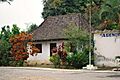
French style house in Paso de Telaya
-
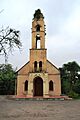
Virgen del Carmen church in Paso de Telaya
-
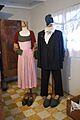
Exhibit of French colonists' dress at the San Rafael Museum
-
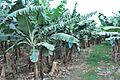
Banana trees at the Rancho La Duena
See also
 In Spanish: Municipio de San Rafael para niños
