
Sandusky Bay facts for kids
Sandusky Bay is a large bay on Lake Erie in northern Ohio. It was formed where the Sandusky River flows into Lake Erie. An old French map from 1718 called it Lac Sandouské. Its name likely comes from Native American languages. The Thomas A. Edison Memorial Bridge was built across the bay to connect highways in Erie and Ottawa counties.
Contents
History of Sandusky Bay
The bay was well-known to the Native American peoples who lived there long ago. This included the Wyandot tribe, who spoke an Iroquoian language. French explorers and settlers called them the Huron people.
Early French explorers claimed this area. A 1718 map by Guillaume Delisle showed the bay as Lac Sandouské. This name later became "Lake Sandusky" in English. The Wyandot people reportedly called the Sandusky River, the bay, and the area around it saundustee, meaning "water," or andusti, meaning "cold water."
In 1734, a historian named Charlevoix wrote the word as "Chinouski." Other old maps show the bay as "L.(Lac) Sandoski" in 1733. It was also called Lac Otsandaské by the French, which was another way of writing the Wyandot name. The Wyandot people lived along the river at its upper and lower waterfalls.
In 1745, a Wyandot leader named Chief Nicolas allowed the English to build a trading post. It was on the north shore of the bay and was called Fort Sandusky. The French knew it as Fort Sandoské. This was the first fort built by Europeans in the Ohio Country. The bay has also been called Lake Junandat and Lake Otsandoské. Other names recorded include Lake Sandusky, Sandoski Bay, and Sandusky Lake.
A French engineer, Gaspard-Joseph Chaussegros de Léry, traveled through this area in 1754. He was leading soldiers to strengthen Fort Detroit at the start of the French and Indian War. He found the old fort's ruins on the north shore of what he called Lac Otsandoské. He then had the French Fort Junandat built in 1754, right across from where the old Fort Sandusky had been.
Geography of Sandusky Bay
Sandusky Bay is one of the main bodies of water in northern Ohio. It is located between Erie, Ottawa, and Sandusky counties. It is part of Lake Erie.
The bay is quite shallow, usually about 12 feet deep. It is about 14 to 15 miles long and around 2 miles wide. It has many marshy areas and several small streams flow into it. Sandusky Bay stretches from Muddy Creek Bay to Cedar Point. Cedar Point is a peninsula that separates Sandusky Bay from Lake Erie. The Sandusky River flows into the bay at its western end.
.jpg)
The Thomas A. Edison Memorial Bridge carries Route 2 and Route 269 across the eastern part of Sandusky Bay. This bridge is the only direct road link between Ottawa and Erie counties. You can also see Sandusky Bay from the Marblehead Lighthouse at Marblehead Lighthouse State Park.
The Sandusky Bay Water Trail opened on June 2, 2007. It provides fun ways to enjoy the bay, like kayaking and canoeing. The water in Sandusky Bay is usually shallow and not very clear. People who like to fish know that Sandusky Bay is a great place for catching crappie fish in early spring.
Current Events at Sandusky Bay
On June 14, 2012, the U.S. Customs and Border Protection agency opened a new station called Sandusky Bay Station.
In July 2012, water samples from Sandusky Bay showed something important. They suggested that invasive Asian carp might have reached Lake Erie. If these fish spread, they could harm Lake Erie's fishing industry, which is worth $1 billion. They could also affect the tourism industry, which is worth $10 billion.
Wars and Rebellions Near Sandusky Bay
- Queen Anne's War (Old French War): On September 20, 1704, Colonel John Bradstreet sailed 60 long boats into Sandusky Bay. His troops then set up camp there.
- War of 1812: During this war, U.S. General William Henry Harrison had his soldiers move boats. They dragged them across a path from Sandusky Bay to Lake Erie. This allowed them to fight British warships on the lake.
- Mackenzie Rebellion of 1837: Canadian rebels planned to cross frozen Lake Erie in the winter. They wanted to go from Sandusky Bay to Pelee Island. However, British soldiers chased them. They found that the people living on the island had already left.
Images for kids
-
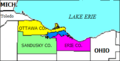
Location of Sandusky Bay (darker blue extending southwest from Lake Erie).
-
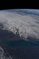
Greenish water flows out of Sandusky Bay (lower left) into Lake Erie in this photo taken on April 12, 2022 from the International Space Station.


See also
 In Spanish: Bahía de Sandusky para niños
