
Satkhira District facts for kids
Quick facts for kids
Satkhira
সাতক্ষীরা
|
|
|---|---|

Location of Satkhira District in Bangladesh
|
|
| Country | |
| Division | Khulna Division |
| Area | |
| • Total | 3,817.29 km2 (1,473.86 sq mi) |
| Population
(2013 census)
|
|
| • Total | 2,079,884 |
| • Density | 544.8588/km2 (1,411.1778/sq mi) |
| Time zone | UTC+06:00 (BST) |
| Postal code |
9400
|
Satkhira (pronounced Sat-khi-ra) is a district in the southwestern part of Bangladesh. It is a part of the Khulna Division. This area is located right next to the border with West Bengal, India. Satkhira sits by the Arpangachhia River. The biggest city and main center of this district is also called Satkhira.
Contents
How Satkhira is Managed
This district has two main towns called municipalities. It also has seven smaller areas known as upazilas. Think of upazilas as sub-districts. There are also 79 "union porishods," which are like local councils for groups of villages. The district has 8 police stations and 1436 villages.
Upazilas of Satkhira
The seven upazilas in Satkhira are:
- Satkhira Sadar Upazila
- Assasuni Upazila
- Debhata Upazila
- Tala Upazila
- Kalaroa Upazila
- Kaliganj Upazila
- Shyamnagar Upazila
Local Leaders
The two main towns are Satkhira and Kalaroa.
- The head of the Zila Porishod (District Council) is Monsur Ahmed.
- The Deputy Commissioner (DC) is Nazmul Ahsan. The DC is a very important government official who helps manage the district.
Satkhira's Geography
Satkhira District covers an area of about 3,817 square kilometers. To the north, it shares a border with Jessore District. The Bay of Bengal is to its south. To the east, you'll find Khulna District. On the west, it borders the 24 Pargana District in West Bengal, India.
Weather and Rivers
The weather in Satkhira can get quite warm. The average highest temperature is about 35.5 degrees Celsius (95.9 degrees Fahrenheit). The lowest temperature is around 12.5 degrees Celsius (54.5 degrees Fahrenheit). The district gets a lot of rain, about 1710 millimeters (67 inches) each year.
Many rivers flow through Satkhira. Some of the main ones are:
- Kopotakhi River
- Morichap River
- Kholpetua River
- Betna River
- Raimangal River
- Hariabhanga river
- Ichamati River
- Betrabati River
- Kalindi-Jamuna River
Satkhira's Climate Type
Satkhira has a tropical savanna climate. This means it's warm all year round, with monthly average temperatures above 18 degrees Celsius (64 degrees Fahrenheit). There is usually a clear dry season. The driest month gets less than 60 millimeters (2.36 inches) of rain. This type of climate is known as "Aw" in the Köppen Climate Classification system.
Images for kids
-
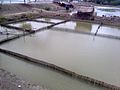
Shrimp hatchery
-
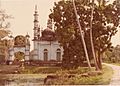
Tetulia Jame Mosque (1858-59)
-
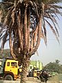
Bhomra land Port
-
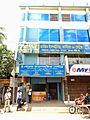
Care Diagnostic Centre & Clinic Satkhira


See also
 In Spanish: Satkhira (zila) para niños
