
Saules, Switzerland facts for kids
Quick facts for kids
Saules
|
||
|---|---|---|

Saules village
|
||
|
||

Saules
Location in Switzerland

Saules
Location in Canton of Bern
|
||
| Country | Switzerland | |
| Canton | Bern | |
| District | Jura bernois | |
| Area | ||
| • Total | 4.28 km2 (1.65 sq mi) | |
| Elevation | 743 m (2,438 ft) | |
| Population
(Dec 2020 )
|
||
| • Total | 147 | |
| • Density | 34.35/km2 (89.0/sq mi) | |
| Postal code |
2732
|
|
| Surrounded by | Reconvilier, Saicourt, Sornetan, Souboz, Loveresse | |

Saules is a small town, also called a "municipality," in Switzerland. It is located in the Bern canton, which is like a state. Saules is part of the Jura Bernois area. In this region, most people speak French.
Contents
Saules Geography and Location

Saules covers an area of about 4.25 square kilometers. This is roughly 1.64 square miles. A big part of the land is used for farming. About 43% of Saules is farmland. Even more of the land, about 52.6%, is covered by forests. Only a small part, about 3.7%, has buildings or roads.
The town of Saules is found in the Trame valley. This valley is close to another town called Reconvilier.
In 2010, Saules became part of a new administrative area. It joined the Jura bernois district. Before that, it was part of the Moutier district.
Saules Coat of Arms
The town of Saules has its own special symbol. It is called a coat of arms. The Saules coat of arms shows three red ears of grain. They are placed on a silver or white background. The ears of grain are arranged in a criss-cross shape. They also stand straight up and down.
Saules Population and People
Saules has a small population. As of 2011, there were 153 people living there. Over the past ten years, the number of people in Saules has changed a little. Some people moved in, and some moved out. Births and deaths also affected the population.
Languages Spoken in Saules
Most people in Saules speak French. About 91.5% of the population speaks French as their main language. German is the second most common language. About 7.9% of people speak German. A very small number of people, about 0.6%, speak Albanian.
Where People Live in Saules
In 2008, there were slightly more women than men in Saules. About 48.7% of the people were men, and 51.3% were women. Most people living in Saules were born in Switzerland. Many were even born right in Saules or in the same canton.
Age Groups in Saules
As of 2011, the population of Saules includes different age groups:
- Children and teenagers (0–19 years old) make up about 26.1% of the population.
- Adults (20–64 years old) make up about 54.2% of the population.
- Seniors (over 64 years old) make up about 19.6% of the population.
Housing in Saules
In 2010, there were 19 homes where only one person lived. There were also 7 homes with five or more people. Most of the apartments in Saules are lived in all the time. A few are used only during certain seasons.
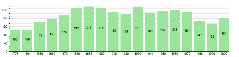
Historical Population of Saules
The chart below shows how the population of Saules has changed over many years.
Saules Economy and Jobs
In 2011, the unemployment rate in Saules was very low, at 1.23%. This means almost everyone who wanted a job had one.
Types of Jobs in Saules
As of 2008, there were 32 people working in Saules. These jobs were in different areas:
- Farming: 20 people worked in agriculture. This is called the primary sector.
- Making Things: 7 people worked in manufacturing or construction. This is the secondary sector.
- Services: 5 people worked in jobs like sales or transportation. This is the tertiary sector.
Most people who live in Saules also work there. However, many people who live in Saules travel to other towns for work.
How People Travel to Work
Many people in Saules use private cars to get to work. About 58.2% of workers use a car. A smaller number, about 9.9%, use public transportation.
Religion in Saules
According to a census in 2000, most people in Saules are Christian.
- About 62.2% belonged to the Swiss Reformed Church.
- About 6.1% were Roman Catholic.
- Another 20.73% belonged to other Christian churches.
- A very small number of people were Islamic.
- About 4.27% of the population did not belong to any church.
Education in Saules

Many adults in Saules have completed a good level of education. About 46.1% have finished non-mandatory high school. About 10.1% have gone on to higher education, like a university.
In 2000, there were no students attending schools right in Saules. However, 19 students from Saules went to schools in other towns nearby.
See also
 In Spanish: Saules (Berna) para niños
