
Reconvilier facts for kids
Quick facts for kids
Reconvilier
|
||
|---|---|---|

Primary School of Reconvilier
|
||
|
||

Reconvilier
Location in Switzerland

Reconvilier
Location in Canton of Bern
|
||
| Country | Switzerland | |
| Canton | Bern | |
| District | Jura bernois | |
| Area | ||
| • Total | 8.25 km2 (3.19 sq mi) | |
| Elevation | 731 m (2,398 ft) | |
| Population
(Dec 2020 )
|
||
| • Total | 2,380 | |
| • Density | 288.5/km2 (747.2/sq mi) | |
| Postal code |
2732
|
|
| Surrounded by | Tavannes, Saicourt, Saules, Loveresse, Malleray, Péry, La Heutte | |

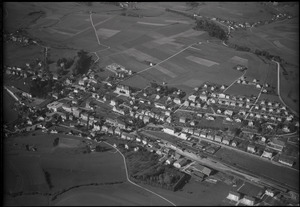
Reconvilier is a small town, also called a municipality, located in the Jura bernois area of the canton of Bern in Switzerland. It is found in the French-speaking part of Switzerland known as the Bernese Jura. This charming town sits in the beautiful Tavannes valley.
Contents
Exploring Reconvilier's Past


Reconvilier was first mentioned in history books way back in 884. Back then, it was called Roconis villare. You might also hear an older German name, Rokwiler, but it's not used anymore.
Ancient Discoveries
The oldest signs of people living here are some ancient bowls. Two are made of ceramic and three are bronze. These bowls likely came from a Roman villa, a large Roman house, built around the 2nd or 3rd century. This shows that people lived in this area a very long time ago!
From Abbey Control to French Rule
In 884, Reconvilier was part of a large estate owned by the Moutier-Grandval Abbey. A noble family, also called Reconvilier, lived here from the 1100s to the 1400s. The village stayed under the Abbey's power until about 1531.
After that, a church leader called a provost took charge. He represented the Prince-Bishop of Basel, a powerful church and political leader. In 1797, France won a war and took control of Reconvilier. It became part of a French area called Mont-Terrible. Later, in 1800, it moved to another French area called Haut-Rhin.
Joining the Canton of Bern
After Napoleon was defeated, the leaders of Europe met at the Congress of Vienna in 1815. They decided that Reconvilier would become part of the Canton of Bern in Switzerland.
Religious Changes in Reconvilier
The Chapel of Saint-Léonard in Chaindon, a small part of Reconvilier, was first mentioned in 962. For most of its history, Reconvilier was part of the church area of Tavannes. In 1530, the people of Tavannes, including Reconvilier, changed their religion to Protestantism.
Reconvilier became its own church area in 1908. The main church you see today was built in 1740. It has been updated a few times, in 1924-26 and again in 1992.
The Rise of Watchmaking
In the mid-1800s, factories started to appear in Reconvilier. In 1851, a factory named Bueche, Boillat et Cie opened. They made parts for watches. A train station opened in 1876, connecting Reconvilier to bigger cities like Basel and Biel. This made it easy to transport goods and helped the town grow into an important center for making watches.
The Bueche, Boillat et Cie company changed its name to Générale Watch Co in 1895. They sold watches under the Helvetia brand until 1975. Another company, Société horlogère, started in 1853. They sold watches as the Reconvilier Watch Company until 1970.
Modern Watchmaking and Industry
Both watch factories closed in the 1970s during a time called the Quartz crisis. This was when new, cheaper quartz watches became popular. However, the Reconvilier Watch Company name was brought back in 2006. Today, it's called Société Horlogère Reconvilier AG. They make classic watches and also high-tech, GPS-based watches for golf players.
In 1855, a metal foundry was built to supply metal to the watch companies. This foundry later became part of a company called Swissmetal in 1989. Even today, making things in factories provides more than half of all jobs in Reconvilier.
Reconvilier's Geography

Reconvilier covers an area of about 8.23 square kilometers. A large part of this land, about 44.7%, is used for farming. Forests cover another big part, about 41.9% of the area.
Buildings and roads take up about 12.8% of the land. A very small amount, 0.1%, is made up of rivers. Most of the forested land is dense forest, and some areas have orchards or small groups of trees. For farming, people grow crops, use land for pastures, and some for alpine pastures.
The town of Reconvilier is located in the Tavannes valley. It includes the main village of Reconvilier and a smaller area called Chaindon.
In 2010, Reconvilier became part of a new administrative district called Jura bernois. This change helped organize the local government better.
Reconvilier's Coat of Arms
The official design of Reconvilier's coat of arms is described as: A silver shield with a wavy black stripe. In the top left corner, there is a black five-pointed star.
People and Population


Reconvilier has a population of about 2,187 people. In 2010, about 16.1% of the people living here were from other countries. Over the past ten years (2001-2011), the population has changed slightly, mostly due to people moving in or out.
Languages Spoken
Most people in Reconvilier speak French as their main language. About 82.7% of the population speaks French. The second most common language is German, spoken by about 6.9% of the people. Italian is the third most common, spoken by about 3.0%.
Who Lives in Reconvilier
In 2008, about 48.9% of the population was male and 51.1% was female. Most people living in Reconvilier were born either in the town itself or in the same canton of Bern. About 18.4% of the residents were born outside of Switzerland.
In 2011, children and teenagers (up to 19 years old) made up about 21.6% of the population. Adults (20-64 years old) made up 58.7%, and seniors (over 64 years old) made up 19.7%.
Homes and Housing
In 2010, there were 351 homes where only one person lived. There were also 58 homes with five or more people. Most apartments in Reconvilier are lived in all the time. In 2011, single family homes made up most of the housing in the town.
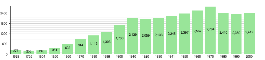
The chart below shows how Reconvilier's population has changed over many years:
Special Places to See
The entire developed area of Reconvilier is recognized as an important Swiss Heritage Site. This means it has special historical or cultural value.
Reconvilier's Economy and Jobs
In 2011, Reconvilier had a low unemployment rate of 2.4%. This means most people who wanted to work had a job. In 2008, there were 814 people working in the town.
Types of Jobs
Jobs in Reconvilier are divided into three main types:
- Primary sector: These jobs involve getting raw materials, like farming. In 2008, 25 people worked in this area, mostly in agriculture.
- Secondary sector: These jobs involve making things in factories. About 353 people worked here. Most of them (75.1%) were in manufacturing, like making watch parts. Others (24.9%) worked in construction.
- Tertiary sector: These jobs involve providing services. About 436 people worked in this sector. This includes jobs in stores, transportation, hotels, restaurants, education, and healthcare.
In 2008, there were 683 full-time jobs in Reconvilier. Over half of all jobs in the town are still in the manufacturing sector.
Commuting and Travel
Many people travel to Reconvilier for work. In 2000, 629 workers came into the town, while 573 workers left to work elsewhere. This means Reconvilier has more people coming in for work than leaving. About 48% of the workers in Reconvilier also live there.
To get to work, 11% of people used public transportation. A larger number, 56.9%, used a private car.
Religion in Reconvilier

Based on a 2000 survey, about 44.8% of the people in Reconvilier belonged to the Swiss Reformed Church (a Protestant church). Another 28.4% were Roman Catholic.
There were also smaller groups of people who belonged to other Christian churches, or were Muslim, Buddhist, or Hindu. About 7.28% of the population did not belong to any church.
Education in Reconvilier

In Reconvilier, about 49.2% of adults have finished high school (called upper secondary education). About 12.4% have gone on to higher education, like a university or a specialized college.
School System in Bern
The Canton of Bern has a specific school system:
- Kindergarten: One year of optional kindergarten.
- Primary School: Six years of primary school.
- Lower Secondary School: Three years of required secondary school. Students are grouped by their abilities.
- After Secondary School: After lower secondary, students can choose to continue their education or start an apprenticeship (learning a trade on the job).
Student Numbers
During the 2011-2012 school year, 266 students attended schools in Reconvilier.
- Kindergarten: 3 classes with 40 students. Some students were from other countries or spoke a different language at home.
- Primary School: 8 classes with 145 students. Again, some students were from other countries or had a different first language.
- Lower Secondary School: 5 classes with 81 students. A small number of these students were from other countries or had a different first language.
In 2000, most students (274 out of 308) lived and went to school in Reconvilier. Some students (34) came from other towns to study here. Also, 70 students from Reconvilier went to schools outside the town.
Transportation in Reconvilier
Reconvilier has its own railway station, called Reconvilier. It is on the Sonceboz-Sombeval–Moutier line. You can catch regular trains from here to Biel/Bienne and Moutier. This makes it easy for people to travel to and from the town.
See also
 In Spanish: Reconvilier para niños
