Scappoose, Oregon facts for kids
Quick facts for kids
Scappoose, Oregon
|
|
|---|---|

The skyline of Scappoose circa 1929
|
|
| Motto(s):
Proactive, Efficient, and Friendly Service
|
|

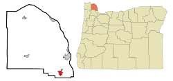
Location in Oregon
|
|
| Country | United States |
| State | Oregon |
| County | Columbia |
| Incorporated | 1921 |
| Government | |
| • Type | Council-Manager |
| • Body | Scappoose City Council |
| Area | |
| • Total | 3.44 sq mi (8.90 km2) |
| • Land | 3.44 sq mi (8.90 km2) |
| • Water | 0.00 sq mi (0.00 km2) |
| Elevation | 59 ft (18 m) |
| Population
(2020)
|
|
| • Total | 8,010 |
| • Density | 2,331.20/sq mi (899.97/km2) |
| Time zone | UTC-8 (Pacific) |
| • Summer (DST) | UTC-7 (Pacific) |
| ZIP code |
97056
|
| Area code(s) | 503 |
| FIPS code | 41-65500 |
| GNIS feature ID | 2411837 |
| Website | www.ci.scappose.or.us |
Scappoose is a city located in Columbia County, Oregon, in the United States. It was named after a nearby stream. This stream flows through the southern part of the county.
The name "Scappoose" comes from a Native American language. It is believed to mean "gravelly plain." In 2020, the city had a population of 8,010 people.
Contents
About Scappoose City
Scappoose is a city in the state of Oregon. It is located in Columbia County. The city was officially formed in 1921.
The city is governed by a Council-Manager system. This means there is a City Council that makes decisions. A City Manager then carries out these decisions. The current mayor is Joe Backus.
Geography and Climate
Scappoose covers a total area of about 3.44 square miles (8.90 square kilometers). All of this area is land.
Climate in Scappoose
Scappoose has a type of weather called a warm-summer Mediterranean climate. This is also known as "Csb" on climate maps. This means the summers are warm and dry. The average monthly temperatures do not get very hot. They stay below 71.6°F (22°C).
The winters are mild and wet. Scappoose gets a good amount of rain each year. Snowfall is usually light.
Population History
Scappoose has grown quite a bit over the years. Here is how its population has changed:
| Historical population | |||
|---|---|---|---|
| Census | Pop. | %± | |
| 1930 | 248 | — | |
| 1940 | 336 | 35.5% | |
| 1950 | 659 | 96.1% | |
| 1960 | 923 | 40.1% | |
| 1970 | 1,859 | 101.4% | |
| 1980 | 3,213 | 72.8% | |
| 1990 | 3,529 | 9.8% | |
| 2000 | 4,976 | 41.0% | |
| 2010 | 6,592 | 32.5% | |
| 2020 | 8,010 | 21.5% | |
| U.S. Decennial Census | |||
Who Lives in Scappoose?
In 2010, there were 6,592 people living in Scappoose. There were 2,536 households. A household is a group of people living together. Most households (53%) were married couples. About 37% of households had children under 18.
The average age of people in Scappoose was 37.8 years. About 26% of residents were under 18 years old. The city's population was almost evenly split between males (48.1%) and females (51.9%).
Economy and Jobs
Scappoose has become a "bedroom community" for Portland, Oregon. This means many people live in Scappoose but travel to Portland for work.
In the past, farming, dairies, and logging were very important. Scappoose also had several factories. These included a shoe factory, two candle factories, and a sauerkraut factory.
Today, the area still has gravel mines. The West Coast Shoe factory is also still in operation. Another important company is Oregon Aero, Inc. They make seats and helmets for airplanes.
To help businesses, the Scappoose City Council has made changes. In 2009, they lowered fees for new businesses. In 2010, they removed business license fees for local companies.
Education in Scappoose
Students in Scappoose attend schools in the Scappoose School District. The schools in the city include:
- Grant Watts Elementary
- Petersen Elementary
- Scappoose Middle School
- Scappoose High School
The school district also includes other schools. These are located in Portland (on Sauvie Island) and Warren.
Transportation Options
Scappoose has several ways to get around.
Airports Near Scappoose
- Scappoose Industrial Airpark: This is a public airport. It is about 1 mile (1.6 km) northeast of the city.
- Chinook Ultralight Airpark: This is a private airport. It is about 3 miles (4.8 km) east of the city.
- Grabhorn's Airport: This is another private airport. It is about 3 miles (4.8 km) north of the city.
Rail and Road Travel
- Northern Pacific Railway: A railway line runs through the area.
- U.S. Route 30 in Oregon: This major highway passes through Scappoose.
Public Bus Service
- Columbia County Rider: This bus service is run by the county. It connects Scappoose with downtown Portland.
Notable People from Scappoose
Many interesting people have connections to Scappoose. Some of them include:
- Derek Anderson – A former NFL quarterback. He was a Pro Bowl player in 2007.
- CC Barber – A winner of the Miss Oregon beauty pageant.
- Betsy Johnson – A well-known politician.
- David Mayo – An NFL linebacker for the Washington Commanders.
- Judith Pella – A popular writer.
- Willy Vlautin – An author, singer, and songwriter.
Images for kids
-
The Peace Candle of the World, a famous landmark in Scappoose.
See also
 In Spanish: Scappoose para niños


