
Schafisheim facts for kids
Quick facts for kids
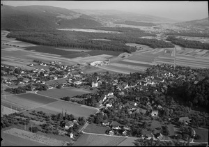
Schafisheim
|
||
|---|---|---|
 |
||
|
||

Schafisheim
Location in Switzerland

Schafisheim
Location in Canton of Aargau
|
||
| Country | Switzerland | |
| Canton | Aargau | |
| District | Lenzburg | |
| Area | ||
| • Total | 6.33 km2 (2.44 sq mi) | |
| Elevation | 419 m (1,375 ft) | |
| Population
(Dec 2020 )
|
||
| • Total | 3,044 | |
| • Density | 480.9/km2 (1,245.5/sq mi) | |
| Postal code |
5503
|
|
| Surrounded by | Gränichen, Hunzenschwil, Rupperswil, Seon, Staufen | |

Schafisheim is a small town, also called a municipality, in the Lenzburg area of the canton of Aargau in Switzerland. It's a place with a long history and a mix of nature and modern life.
Contents
A Look at Schafisheim's Past
People have lived near Schafisheim for a very long time. We know this because old burial sites from the Hallstatt period (around 800-450 BC) and a Roman-era farm have been found here.
The village of Schafisheim was first written about between 1261 and 1264. Back then, it was called Scafusa. Important legal power over the area was held by the Habsburg family. Later, in 1415, this power went to Bern.
A farm owned by a place called Murbach Abbey had control over local laws and property rights in the village until 1482. This local control then passed to different noble families, including a part of the Hallwyl family. In the 15th century, the main local rulers likely lived at Schafisheim Castle.
The first mention of a small church, or chapel of ease, in Schafisheim was in 1360. It was part of the Staufen church area. Between 1496 and 1498, a new church, St. Leodegar, was built where the old chapel stood. A nearby farming settlement called Bettetal joined Schafisheim in 1751.
For a long time, Schafisheim's economy relied on farming and a little bit of grape growing. People also made things at home in the 1800s. In 1736, two brothers, Samuel and Etienne Brutel, started a successful printing business, but it closed before 1800. In the 19th and 20th centuries, many people from Schafisheim worked in factories in other countries.
When the A1 motorway opened in 1967, it brought big changes. New businesses like logistics centers (places for storing and moving goods) and furniture stores came to the area. In 1973, the cantonal road traffic office also moved here. The village grew a lot with new homes and shops along the road between Aarau and Lenzburg.
Where is Schafisheim?

Schafisheim covers an area of about 6.33 square kilometers (2.44 square miles). A large part of this land is used for farming (38.1%) or is covered by forests (41.1%). About 20.9% of the land has buildings or roads on it. A very small part (0.5%) is rivers or lakes.
Looking closer at the developed areas, industrial buildings make up 3.2% of the total, while homes and other buildings are 9.5%. Roads and other transport areas are 5.1%. Power and water facilities, along with other special developed areas, make up 2.8%. All the forested land is covered with thick forests.
For farming, 24.5% of the land is used for growing crops, and 11.4% is for pastures where animals graze. Another 2.2% is used for fruit trees or grapevines. All the water in Schafisheim is found in its rivers and streams.
The town is located in the Lenzburg district, at the lower end of the Seetal valley. It includes the main village of Schafisheim and two smaller settlements called hamlets: Bettetal and Heuelmüli.
What Does the Coat of Arms Mean?
The design on Schafisheim's coat of arms shows a silver sheep walking on a red background. This design is a fun way to represent the town's name, as "Schaf" means "sheep" in German!
Who Lives in Schafisheim?
Schafisheim has a population of about 3,062 people (as of 2020). In 2009, about 17.5% of the people living here were from other countries. Most people in Schafisheim speak German (90.7%). Italian is the second most common language (2.7%), followed by Albanian (1.5%).
The age groups in Schafisheim (as of 2008) are:
- Children aged 0-9: 10.5%
- Teenagers aged 10-19: 14.2%
- Young adults aged 20-29: 10.8%
- Adults aged 30-39: 12.8%
- Adults aged 40-49: 17.4%
- Adults aged 50-59: 15.2%
- Seniors aged 60-69: 11.4%
- Seniors aged 70-79: 5.5%
- Seniors aged 80-89: 2.0%
- Seniors aged 90 and older: 0.3%
In 2000, there were 970 homes and apartments in Schafisheim, with an average of 2.6 people living in each. In 2008, more than half of the homes (50.6%) were single-family houses. Only a small number of apartments (1.5%) were empty.
In the 2007 national election, the most popular political party was the SVP, which got 38.4% of the votes. Other popular parties included the SP (17%), the FDP (11.1%), and the Green Party (9.2%).
Here's how the population of Schafisheim has changed over time:
| Historical population | ||
|---|---|---|
| Year | Pop. | ±% |
| 1764 | 577 | — |
| 1831 | 1,131 | +96.0% |
| 1850 | 1,068 | −5.6% |
| 1900 | 868 | −18.7% |
| 1950 | 1,383 | +59.3% |
| 2000 | 2,656 | +92.0% |
| 2010 | 2,795 | +5.2% |
| 2020 | 3,062 | +9.6% |
Important Buildings in Schafisheim
Two buildings in Schafisheim are considered very important Swiss heritage sites. These are the Haus Urech (Urech House) at Seetalstrasse 27 and the Schlössli (which means "small castle") at Lenzburgerstrasse 5 and 7.
How People Make a Living
In 2007, Schafisheim had a low unemployment rate of 1.76%. This means most people who wanted to work had jobs.
The economy of Schafisheim is divided into three main parts:
- Primary Sector: This involves jobs like farming. In 2005, 76 people worked in this area, with about 19 businesses.
- Secondary Sector: This includes jobs in manufacturing and construction. There were 421 people working in this sector, with 30 businesses.
- Tertiary Sector: This covers service jobs, like working in shops, offices, or schools. This is the largest sector, with 1,440 people employed and 74 businesses.
In 2000, 1,361 people who lived in Schafisheim had jobs. Most of them (77.7%) traveled outside Schafisheim for work. However, 1,245 people came into Schafisheim to work. This means there were 1,548 jobs available in the town. About 10.7% of workers used public transport to get to work, while 58.2% drove their own cars.
Religions in Schafisheim
Based on the 2000 census:
- 565 people (22.4%) were Roman Catholic.
- 1,426 people (56.6%) belonged to the Swiss Reformed Church (a Protestant church).
- A very small number (0.08%) belonged to the Christian Catholic Church of Switzerland.
Learning and Schools
Education is important in Schafisheim. About 74.5% of adults (aged 25 to 64) have completed either high school or gone on to higher education, like university.
In the 2008/2009 school year:
- 304 students attended primary school.
- 182 students attended secondary school in the municipality.
See also
 In Spanish: Schafisheim para niños
