Schoenchen, Kansas facts for kids
Quick facts for kids
Schoenchen, Kansas
|
|
|---|---|

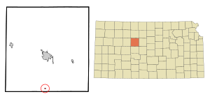
Location within Ellis County and Kansas
|
|

|
|
| Country | United States |
| State | Kansas |
| County | Ellis |
| Founded | 1877 |
| Incorporated | 1935 |
| Named for | Schoenchen, Russia |
| Area | |
| • Total | 0.12 sq mi (0.32 km2) |
| • Land | 0.12 sq mi (0.32 km2) |
| • Water | 0.00 sq mi (0.00 km2) |
| Elevation | 1,923 ft (586 m) |
| Population
(2020)
|
|
| • Total | 170 |
| • Density | 1,420/sq mi (531/km2) |
| Time zone | UTC-6 (CST) |
| • Summer (DST) | UTC-5 (CDT) |
| ZIP code |
67667
|
| Area code | 785 |
| FIPS code | 20-63425 |
| GNIS|GNIS ID | 2396555 |
Schoenchen is a small city in Ellis County, Kansas, United States. It's a quiet place with a rich history. In 2020, about 170 people lived there.
Contents
A Look Back: Schoenchen's History
Schoenchen was started in April 1877 by settlers from Germany who had moved to Russia and then to America. They had a disagreement about moving a nearby town called Liebenthal. So, they decided to create their own community.
They first named their new home San Antonio. But later, they changed it to Schoenchen. This new name came from one of the villages they had lived in back in Russia.
The settlers built their first church in 1880. In 1901, they built a stronger, more lasting church called St. Anthony Catholic Church, which is still standing today. The town's first post office opened in 1902.
Where is Schoenchen? Geography and Climate
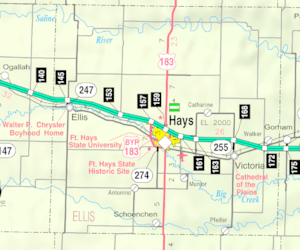
Schoenchen is located in Kansas, about 11 miles (18 km) south of Hays, which is the main city of Ellis County. It's also about 137 miles (220 km) northwest of Wichita and 264 miles (425 km) west of Kansas City.
The city is found on the south side of the Smoky Hill River. This area is part of the Smoky Hills region, which is a section of the larger Great Plains. The city covers a total area of about 0.11 square miles (0.28 square kilometers), and all of it is land.
Schoenchen's Weather: Climate Basics
The weather in Schoenchen usually has hot and humid summers. Winters are generally mild to cool. This type of weather is known as a humid subtropical climate. On climate maps, you might see it labeled as "Cfa."
Who Lives Here? Demographics
| Historical population | |||
|---|---|---|---|
| Census | Pop. | %± | |
| 1940 | 259 | — | |
| 1950 | 170 | −34.4% | |
| 1960 | 188 | 10.6% | |
| 1970 | 182 | −3.2% | |
| 1980 | 209 | 14.8% | |
| 1990 | 128 | −38.8% | |
| 2000 | 214 | 67.2% | |
| 2010 | 207 | −3.3% | |
| 2020 | 170 | −17.9% | |
| U.S. Decennial Census | |||
Schoenchen's Population in 2010
In 2010, there were 207 people living in Schoenchen. These people lived in 76 different homes, and 59 of these were families.
Most of the people living in Schoenchen were White (96.6%). About 1.9% were Native American, and 1.4% were from other races. About 1.9% of the population identified as Hispanic or Latino.
About 36.8% of homes had children under 18 living there. Most homes (63.2%) were married couples living together. The average home had about 2.72 people, and the average family had about 3.10 people.
The population was spread out by age:
- 25.6% were under 18 years old.
- 12.6% were between 18 and 24.
- 23.2% were between 25 and 44.
- 25.6% were between 45 and 64.
- 13.0% were 65 years or older.
The average age in Schoenchen was 35.2 years.
Working in Schoenchen: Economy
In 2012, most people over 16 years old in Schoenchen were working or looking for work. Many jobs were in areas like management, business, and science. Others worked in production, transportation, sales, office jobs, or service roles.
The main industries that employed people were:
- Education and healthcare.
- Manufacturing (making goods).
- Retail trade (stores).
Living in Schoenchen is not very expensive. The cost of living is lower than the average for the United States. In 2012, the average home value was $85,000.
Learning in Schoenchen: Education
The public schools in Schoenchen are part of the Hays USD 489 school district.
Schoenchen used to have its own high school. It was called Schoenchen High School, and its mascot was the Bluejays. However, the high school closed in 1966 because schools were being combined.
Schoenchen Elementary School stayed open for several years after the high school closed. Its mascot was the Cardinals.
Getting Around: Infrastructure
Transportation in Schoenchen
U.S. Route 183 is a main road that runs north and south about 0.5 miles (0.8 km) east of Schoenchen. Schoenchen Road, a paved county road, goes east and west right through the city.
Utilities for Residents
Most homes in Schoenchen use stored gas for heating.
Schoenchen on TV: Media
Schoenchen is part of the Wichita-Hutchinson, Kansas television market. This means residents watch TV channels that serve this larger area.
Fun in Schoenchen: Culture
Places to Visit: Points of Interest
The Schoenchen Community Center is a special place in town. It used to be a bar and grill, but now it's used for voting and community events. It's also where Schoenchen's yearly German Feast is held, which sounds like a lot of fun!
See also
 In Spanish: Schoenchen para niños
 | Valerie Thomas |
 | Frederick McKinley Jones |
 | George Edward Alcorn Jr. |
 | Thomas Mensah |

