
Schwaz District facts for kids
Quick facts for kids
Schwaz District
Bezirk Schwaz
|
|
|---|---|
 |
|
| Country | Austria |
| State | Tyrol |
| Number of municipalities | 39 |
| Area | |
| • Total | 1,887.49 km2 (728.76 sq mi) |
| Population
(2012)
|
|
| • Total | 79,511 |
| • Density | 42.1253/km2 (109.1039/sq mi) |
| Time zone | UTC+01:00 (CET) |
| • Summer (DST) | UTC+02:00 (CEST) |
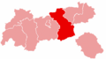
The Schwaz District is a special area in Tyrol, Austria. It is like a county or region. This district is located in the western part of Austria.
It shares borders with different places. To the north, it touches Bavaria in Germany. To the east, it borders other Austrian districts like Kufstein, Kitzbühel, and Pinzgau in the state of Salzburg. In the south, it connects with South Tyrol in Italy. To the west, it is next to the Innsbruck-Land district.
The Schwaz District covers an area of about 1,887 square kilometers. That's a pretty big space! In 2019, about 83,873 people lived here. The main town and administrative center of the district is Schwaz. This is where important offices are located.
Towns and Villages in Schwaz District
The Schwaz District is made up of 39 different municipalities. These are like smaller towns and villages that work together. Each municipality has its own local government.
Here is a list of the municipalities in the Schwaz District:
- Achenkirch
- Aschau im Zillertal
- Brandberg
- Bruck am Ziller
- Buch in Tirol
- Eben am Achensee
- Finkenberg
- Fügen
- Fügenberg
- Gallzein
- Gerlos
- Gerlosberg
- Hainzenberg
- Hart im Zillertal
- Hippach
- Jenbach
- Kaltenbach
- Mayrhofen
- Pill
- Ramsau im Zillertal
- Ried im Zillertal
- Rohrberg
- Schlitters
- Schwaz
- Schwendau
- Stans
- Steinberg am Rofan
- Strass im Zillertal
- Stumm
- Stummerberg
- Terfens
- Tux
- Uderns
- Vomp
- Weer
- Weerberg
- Wiesing
- Zell am Ziller
- Zellberg
Images for kids
-
Map showing the location of Schwaz District in Tyrol.
See also
 In Spanish: Distrito de Schwaz para niños
