Seal Bay, South Australia facts for kids
Quick facts for kids Seal BaySouth Australia |
|||||||||||||||
|---|---|---|---|---|---|---|---|---|---|---|---|---|---|---|---|

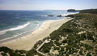
View (looking west) from within the Seal Bay Conservation Park
|
|||||||||||||||
| Population | 560 (shared with other localities in the “State Suburb of Nepean Bay”) (2011 census) | ||||||||||||||
| Established | 2002 | ||||||||||||||
| Postcode(s) | 5223 | ||||||||||||||
| Time zone | ACST (UTC+9:30) | ||||||||||||||
| • Summer (DST) | ACST (UTC+10:30) | ||||||||||||||
| Location |
|
||||||||||||||
| LGA(s) | Kangaroo Island Council | ||||||||||||||
| Region | Fleurieu and Kangaroo Island | ||||||||||||||
| County | County of Carnarvon | ||||||||||||||
| State electorate(s) | Mawson | ||||||||||||||
| Federal Division(s) | Mayo | ||||||||||||||
|
|||||||||||||||
|
|||||||||||||||
| Footnotes | Location Coordinates Climate Adjoining localities |
||||||||||||||
Seal Bay is a special place in South Australia. It's a small area located on the south coast of Kangaroo Island. This beautiful spot looks out over the big ocean, which is called the Southern Ocean in Australia. Some international maps call this area the Great Australian Bight.
Seal Bay is about 164 kilometers (102 miles) southwest of Adelaide, the capital city of South Australia. It's also about 50 kilometers (31 miles) south of Kingscote, which is the main town on Kangaroo Island. The name "Seal Bay" has been used for a long time, and its official boundaries were set in 2002.
Exploring Seal Bay's Land
Most of the land in Seal Bay is used for conservation. This means it's protected to keep nature safe and healthy. A smaller part of the area, right in the middle, is used for agriculture. This is where people grow crops or raise animals.
Protected Areas in Seal Bay
The conservation land includes the entire Seal Bay Conservation Park. This park is famous for its Australian sea lions. It's a great place to see these amazing animals in their natural home. Part of the Cape Gantheaume Wilderness Protection Area also stretches into the eastern side of Seal Bay. This area is even more wild and protected.
How Seal Bay is Governed
Seal Bay is part of a few different government areas. These areas help manage and represent the people who live there.
Local and State Government
Locally, Seal Bay is part of the Kangaroo Island Council. This council helps with things like roads, parks, and local services. For state government, it's in the electoral district of Mawson. This means people in Seal Bay vote for a representative in the state parliament.
Federal Government Representation
At the national level, Seal Bay is part of the federal division of Mayo. This division has a representative in the Australian Parliament in Canberra. These different levels of government work together to make sure Seal Bay is a great place to live and visit.
 | Kyle Baker |
 | Joseph Yoakum |
 | Laura Wheeler Waring |
 | Henry Ossawa Tanner |


