Seal River (Manitoba) facts for kids
Quick facts for kids Seal River |
|
|---|---|
|
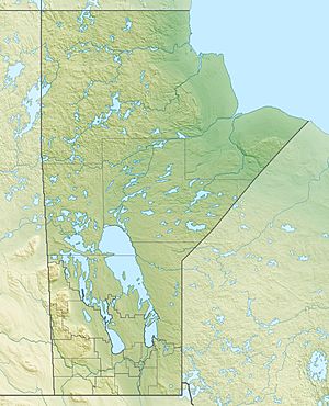
Course and location of the mouth of the Seal River in Manitoba
|
|
| Country | Canada |
| Province | Manitoba |
| Region | Northern Manitoba |
| Physical characteristics | |
| Main source | Shethanei Lake 58°47′59″N 97°49′59″W / 58.79972°N 97.83306°W |
| River mouth | Hudson Bay 59°4′19″N 94°47′56″W / 59.07194°N 94.79889°W |
| Length | 260 km (160 mi) |
| Basin features | |
| Basin size | 50,000 km2 (19,000 sq mi) |
The Seal River is a cool river located in the northern part of Manitoba, Canada. It flows for about 260 kilometers (162 miles) all the way from Shethanei Lake to the huge Hudson Bay. This river is super special because it was named a Canadian Heritage Rivers System river in 1992, recognized for its amazing natural beauty and wildness. It's named after the harbour seals that can be found far up the river, sometimes as much as 200 kilometers (124 miles) inland!
Contents
Exploring the Seal River's Geography
The Seal River is one of the four main rivers in Northern Manitoba. It stretches for 260 kilometers (162 miles). What makes it unique is that it's the most northern of these rivers and has no dams on it at all.
Where is the Seal River Located?
The river's drainage basin (the area of land where all the water drains into the river) covers a huge 50,000 square kilometers (19,300 square miles). This river is in a very remote and wild area, far from any towns or cities.
The closest towns are Churchill and the small community of Tadoule Lake. Churchill is about 45 kilometers (28 miles) south of where the river meets Hudson Bay. Tadoule Lake is much further inland, closer to where the river starts.
There are no permanent homes or people living right along the Seal River. The closest paved road is about 275 kilometers (171 miles) southwest of the river. The Seal River officially starts at Shethanei Lake. However, the water for this lake comes from two even longer rivers, the North Seal River and the South Seal River.
What is the Landscape Like?
The Seal River flows through a special area where two different types of land meet. It passes through thick boreal forests at the very southern edge of Canada's tundra.
Because of this, you'll see both dense trees and parts of the rocky, open subarctic wilderness. The river's path is not straight or calm. It has many twists, turns, and rapids, making it very tricky and dangerous to travel by boat.
The river is mostly untouched by people. Only a few very skilled adventurers, using rafts or canoes, dare to travel its challenging waters each year.
The History of the Seal River
The Seal River was chosen for the Canadian Heritage Rivers System in 1987. It was recognized for its incredible natural environment and importance to wildlife, not because people used it for development. The entire river is wild and undeveloped, far from human activity. It's known as one of Canada's last truly wild rivers.
Early Explorers and First Nations
While early European settlers in the Hudson Bay area didn't use the river much, it was very important to First Nations people many centuries ago. The first European to explore the Seal River was Samuel Hearne. He walked along the river's route in 1771.
Europeans didn't find much use for the river. The only signs of their presence were short-lived mining camps near the river's mouth, which were used in the 1940s.
However, there are many old items left behind by the Chipewyan people and even older Talteilei tribes. These groups regularly visited the river to hunt the large numbers of caribou. Evidence shows that First Nations people have been in this area for up to 7,000 years!
Visiting the Seal River Today
Getting to the Seal River is very difficult because there are no public roads or easy ways to travel there. You can only reach the area by flying into distant airports, like Churchill Airport or Tadoule Lake Airport. After that, you usually have to hike the rest of the way to the river.
Guided tours of the river and the surrounding area are rare and very expensive. Because the river is so isolated and its landscape is so dangerous, very few adventurers visit it each year. The river has stayed wild and protected because of the harsh wilderness, poor soil, and very cold climate. These conditions make the area very challenging for even the most experienced travelers.
 | Misty Copeland |
 | Raven Wilkinson |
 | Debra Austin |
 | Aesha Ash |


