
Segundo, Ponce, Puerto Rico facts for kids
Quick facts for kids
Segundo
|
|
|---|---|
.jpg)
A street in Barrio Segundo at dusk, in the Ponce Historic Zone
|
|

Location of barrio Segundo within the municipality of Ponce shown in red
|
|

Segundo, Ponce, Puerto Rico
Location in Caribbean
|
|
| Commonwealth | |
| Municipality | |
| Area | |
| • Total | 0.53 sq mi (1.4 km2) |
| • Land | 0.53 sq mi (1.4 km2) |
| • Water | 0 sq mi (0 km2) |
| Elevation | 85 ft (26 m) |
| Population
(2010)
|
|
| • Total | 7,213 |
| • Density | 13,609.4/sq mi (5,254.6/km2) |
| Source: 2010 Census | |
| Time zone | UTC−4 (AST) |
Segundo (which means Second in Spanish) is one of the 31 neighborhoods, or barrios, in the city of Ponce, Puerto Rico. It's one of the six main urban barrios that form the heart of Ponce. Segundo was officially created in 1878. It includes three smaller areas: Baldority de Castro (also called "Baldorioty"), Clausells, and Reparada.
Contents
Where is Segundo Located?
Segundo is an urban barrio, meaning it's part of the city area. You can find it in the southern part of the municipality of Ponce. It's located inside the city limits, just northwest of the main city square, Plaza Las Delicias.
What are Segundo's Borders?
Segundo is surrounded by several streets and other barrios.
- To the north, it's bordered by Cinco Street, Pico Dulce Street, and Paseo de la Cruceta.
- To the south, you'll find Villa Street.
- Global Street forms its western border.
- To the east, it's next to Atocha, Plaza Munoz Rivera, and Plaza Degetau Streets.
When looking at its borders with other barrios:
- Portugués Urbano is to the north.
- Primero and Canas Urbano are to the south.
- Canas Urbano is also to the west.
- Sexto, Quinto, and Tercero are to the east.
The communities of Clausells, Ferran, and Tamarindo are all part of Segundo.

Facts and Figures About Segundo
Segundo covers about 0.6 square miles (1.6 square kilometers) of land. It doesn't have any water areas within its borders.
In 2000, about 11,321 people lived in Segundo. By 2010, the population was 7,213 people. This means that in 2010, there were about 13,609 people living in every square mile of Segundo, showing it's a busy, populated area!
Famous Places in Segundo
Segundo is home to many important landmarks and historic sites in Ponce. Some of these include:
- Plaza Las Delicias: This is the main town square, a beautiful and central spot.
- 25 de Enero Street: A historic street known for its unique architecture.
- Paseo Atocha: A lovely promenade perfect for walks.
Many buildings listed on the National Register of Historic Places (NRHP) are also in Barrio Segundo. These include:
- Parque de Bombas: A famous old firehouse that is now a museum.
- Nuestra Señora de la Guadalupe Cathedral: A beautiful cathedral.
- Armstrong-Poventud Residence: A historic home.
- Casa Wiechers-Villaronga (Architecture Museum): A museum dedicated to architecture.
- Panteón Nacional Román Baldorioty de Castro: A cemetery that is also a national monument.
- Albergue Caritativo Tricoche: A charitable shelter.
- Casa Miguel C. Godreau: Another historic home.
- Subira House: A notable residence.
Images for kids
-
International food restaurants at the Ponce Plaza Hotel & Casino
-
Restaurant signs at the Ponce Plaza Hotel & Casino
-
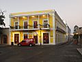
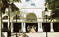
Ponce Plaza Hotel & Casino on Calle Union and Plaza Las Delicias
-
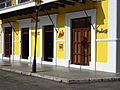
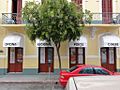
Puerto Rican 'Criollo' food restaurant on Calle Reina near Calle Union
-
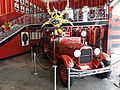
Fire truck at Museo Parque de Bombas at Plaza Las Delicias
-
Homes near downtown Ponce on Calle Reina
-
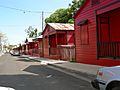
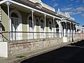
Historic firemen homes on Calle 25 de Enero
-
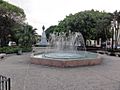
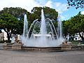
Fountain at Plaza Las Delicias
-
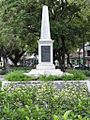
Monument to the 1899 fire heroes at Plaza Las Delicias
-
Cemetery museum 6 blocks northwest of downtown Ponce
-
Porta Caribe tourist welcome center on Calle Villa
-
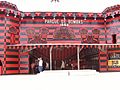
1882 Museo Parque de Bombas at Plaza Las Delicias
-
Lions Fountain at Plaza Las Delicias
.jpg)
.jpg)
.jpg)
.jpg)
.jpg)
.jpg)
.jpg)
.jpg)

.jpg)


See also
 In Spanish: Segundo (Ponce) para niños
- List of communities in Puerto Rico
