Sennett, New York facts for kids
Quick facts for kids
Sennett, New York
|
|
|---|---|
| Motto(s):
A family-oriented town in Cayuga County that is rich in history
|
|

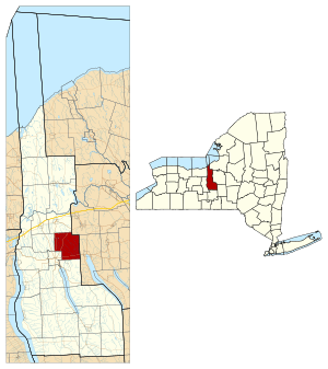
Location within Cayuga County and New York
|
|
| Country | United States |
| State | New York |
| County | Cayuga |
| Government | |
| • Type | Town Council |
| Area | |
| • Total | 28.84 sq mi (74.70 km2) |
| • Land | 28.82 sq mi (74.64 km2) |
| • Water | 0.02 sq mi (0.06 km2) |
| Elevation | 771 ft (235 m) |
| Population
(2010)
|
|
| • Total | 3,595 |
| • Estimate
(2016)
|
3,550 |
| • Density | 123.18/sq mi (47.56/km2) |
| Time zone | UTC-5 (Eastern (EST)) |
| • Summer (DST) | UTC-4 (EDT) |
| ZIP code |
13021
|
| Area code(s) | 315 |
| FIPS code | 36-011-66443 |
| GNIS feature ID | 0979482 |
Sennett is a small town in Cayuga County, New York, United States. In 2010, about 3,595 people lived there. The town got its name from Daniel Sennett, an important early settler and public official. Sennett is on the eastern edge of Cayuga County, right next to the city of Auburn.
Contents
History of Sennett
The land that is now Sennett was once part of the Central New York Military Tract. This land was set aside for soldiers who fought in wars. Daniel Sennett, a well-known judge, moved to this area in 1795.
Sennett became its own town on March 19, 1827. It was formed from parts of the towns of Brutus and Aurelius. Later, in 1859, some of Sennett's land was given to help create the town of Throop. Sennett also gave some land to the city of Auburn.
The Sennett Federated Church and Parsonage was built in 1848. It is a historic building and is listed on the National Register of Historic Places.
Geography of Sennett
Sennett covers a total area of about 28.8 square miles (74.7 km2). Only a very small part of this, about 0.023 square miles (0.06 km2), is water.
The eastern border of Sennett is also the border of Onondaga County. Sennett is located in the Finger Lakes region. It is close to the northern ends of Owasco Lake and Skaneateles Lake.
Several main roads pass through Sennett. New York State Route 5 runs northeast to southwest. New York State Route 34 runs north to south. These roads connect with U.S. Route 20 in the nearby city of Auburn.
Population and People
| Historical population | |||
|---|---|---|---|
| Census | Pop. | %± | |
| 1830 | 2,297 | — | |
| 1840 | 2,060 | −10.3% | |
| 1850 | 2,347 | 13.9% | |
| 1860 | 1,923 | −18.1% | |
| 1870 | 1,748 | −9.1% | |
| 1880 | 1,644 | −5.9% | |
| 1890 | 1,498 | −8.9% | |
| 1900 | 1,440 | −3.9% | |
| 1910 | 1,423 | −1.2% | |
| 1920 | 1,358 | −4.6% | |
| 1930 | 1,528 | 12.5% | |
| 1940 | 1,664 | 8.9% | |
| 1950 | 1,730 | 4.0% | |
| 1960 | 2,283 | 32.0% | |
| 1970 | 2,553 | 11.8% | |
| 1980 | 2,561 | 0.3% | |
| 1990 | 2,913 | 13.7% | |
| 2000 | 3,244 | 11.4% | |
| 2010 | 3,595 | 10.8% | |
| 2016 (est.) | 3,550 | −1.3% | |
| U.S. Decennial Census | |||
In 2000, there were 3,244 people living in Sennett. There were 1,085 households, and most of them (864) were families. The average household had about 2.75 people. The average family had about 3.1 people.
About 27.1% of the people in Sennett were under 18 years old. About 16.2% were 65 years or older. The average age of people in Sennett was 39 years.
Communities and Landmarks
- McMasters Corners – This area is located on NY-34, west of the main Sennett village.
- Sennett (once called "Fellows Corners") – This is the main hamlet or village of Sennett. It is located on NY-5, northeast of Auburn.
- Wicks Corners – This hamlet is near the eastern town line, east of Auburn.
- Sennett Federated Church – This important church was built in 1829. It is still used today and is located north of NY-5. It is at the corner of Turnpike Road and Weedsport-Sennett Road. This church is also listed on the National Register of Historic Places.
Notable People from Sennett
- Brandon Williams – A businessman and politician.
- Charles Clinton Adams – A businessman and politician.
- Chester Gillette – A person of historical interest.
- John Hulbert – A person of historical interest.
See also
 In Spanish: Sennett (Nueva York) para niños


