Seymour, Texas facts for kids
Quick facts for kids
Seymour, Texas
|
|
|---|---|
|
City
|
|
|
Baylor County Courthouse in Seymour
|
|

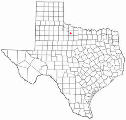
Location of Seymour, Texas
|
|
| Country | United States |
| State | Texas |
| County | Baylor |
| Incorporated (town) | 1890 (dissolved 1892) |
| Incorporated (city) | 1906 |
| Government | |
| • Type | Mayor-Council |
| Area | |
| • Total | 2.93 sq mi (7.59 km2) |
| • Land | 2.92 sq mi (7.57 km2) |
| • Water | 0.01 sq mi (0.01 km2) |
| Elevation | 1,289 ft (393 m) |
| Population
(2020)
|
|
| • Total | 2,575 |
| • Density | 878.8/sq mi (339.26/km2) |
| Time zone | UTC-6 (Central (CST)) |
| • Summer (DST) | UTC-5 (CDT) |
| ZIP code |
76380
|
| Area code(s) | 940 |
| FIPS code | 48-66968 |
| GNIS feature ID | 2411871 |
Seymour is a city in Baylor County, Texas, United States. It is also the main town, or county seat, of Baylor County. In 2020, about 2,575 people lived there.
Contents
Where is Seymour Located?
Seymour is found along the Brazos River. It is about 52 miles (84 km) southwest of Wichita Falls. It is also about 102 miles (164 km) north-northeast of Abilene.
The city covers a total area of about 2.93 square miles (7.6 square kilometers). Most of this area is land, with only a very small part covered by water.
What is Seymour's Weather Like?
Seymour has a humid subtropical climate. This means it has hot, humid summers. Winters are usually mild to cool, but can sometimes get cold.
On August 12, 1936, Seymour recorded the highest temperature ever in Texas. It reached 120 °F (49 °C)! This record was later matched by another Texas city in 1994.
| Climate data for Seymour, TX | |||||||||||||
|---|---|---|---|---|---|---|---|---|---|---|---|---|---|
| Month | Jan | Feb | Mar | Apr | May | Jun | Jul | Aug | Sep | Oct | Nov | Dec | Year |
| Record high °F (°C) | 89 (32) |
93 (34) |
100 (38) |
103 (39) |
107 (42) |
115 (46) |
114 (46) |
120 (49) |
112 (44) |
106 (41) |
92 (33) |
90 (32) |
120 (49) |
| Mean daily maximum °F (°C) | 54.1 (12.3) |
58.5 (14.7) |
67.2 (19.6) |
77.3 (25.2) |
84.5 (29.2) |
92.6 (33.7) |
97.6 (36.4) |
97.7 (36.5) |
89.3 (31.8) |
78.8 (26.0) |
65.4 (18.6) |
55.5 (13.1) |
76.5 (24.8) |
| Mean daily minimum °F (°C) | 27.1 (−2.7) |
31.4 (−0.3) |
38.8 (3.8) |
48.9 (9.4) |
58.4 (14.7) |
67.3 (19.6) |
71.2 (21.8) |
70.2 (21.2) |
62.4 (16.9) |
50.9 (10.5) |
38.1 (3.4) |
29.7 (−1.3) |
49.5 (9.8) |
| Record low °F (°C) | −14 (−26) |
−9 (−23) |
5 (−15) |
22 (−6) |
30 (−1) |
47 (8) |
54 (12) |
50 (10) |
34 (1) |
20 (−7) |
7 (−14) |
−8 (−22) |
−14 (−26) |
| Average precipitation inches (mm) | 0.99 (25) |
1.41 (36) |
1.57 (40) |
2.18 (55) |
3.79 (96) |
3.20 (81) |
2.21 (56) |
2.30 (58) |
3.09 (78) |
2.61 (66) |
1.55 (39) |
1.36 (35) |
26.26 (665) |
| Average snowfall inches (cm) | 0.8 (2.0) |
0.6 (1.5) |
0.2 (0.51) |
0 (0) |
0 (0) |
0 (0) |
0 (0) |
0 (0) |
0 (0) |
0 (0) |
0.3 (0.76) |
0.4 (1.0) |
2.3 (5.77) |
| Source: WRCC | |||||||||||||
What is the Geology of Seymour?
Seymour is located in an area known for its Texas Red Beds. These are layers of red-colored rock that formed a very long time ago, during the Early Permian period.
These Red Beds are famous for their fossils. In 1877, Edward Drinker Cope found the first fossils of Permian-period animals with backbones here. Later, scientists found rare fossils of ancient amphibians like Trimerorhachis. They also found many fossils of other tetrapods (animals with four limbs) like Dimetrodon and Diadectes.
The group of animals called Seymouriamorpha and a specific animal called Seymouria were first discovered near Seymour. They are named after the city!
Who Lives in Seymour?
| Historical population | |||
|---|---|---|---|
| Census | Pop. | %± | |
| 1880 | 183 | — | |
| 1890 | 1,125 | 514.8% | |
| 1910 | 2,029 | — | |
| 1920 | 2,121 | 4.5% | |
| 1930 | 2,626 | 23.8% | |
| 1940 | 3,328 | 26.7% | |
| 1950 | 3,779 | 13.6% | |
| 1960 | 3,789 | 0.3% | |
| 1970 | 3,469 | −8.4% | |
| 1980 | 3,657 | 5.4% | |
| 1990 | 3,185 | −12.9% | |
| 2000 | 2,908 | −8.7% | |
| 2010 | 2,740 | −5.8% | |
| 2020 | 2,575 | −6.0% | |
| U.S. Decennial Census 2020 | |||
Population in 2020
In 2020, the census counted 2,575 people living in Seymour. There were 1,309 households and 839 families.
Most people in Seymour are White (about 78.41%). About 14.17% of the population is Hispanic or Latino. Other groups include Black or African American, Native American, Asian, and people of mixed races.
Population in 2010
In 2010, Seymour had 2,740 residents. This was a small decrease from the year 2000. Most of the people were White (91.28%). About 2.45% were African American, and 3.6% were Hispanic or Latino.
Education in Seymour
Students in Seymour attend schools that are part of the Seymour Independent School District.
The Story of Seymour
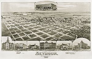
Seymour was started by settlers from Oregon. They first called the town Oregon City. It was built where the Western Trail crossed the Brazos River.
In 1879, a post office was set up, and the town's name changed. It was named after Seymour Munday, a local cowboy. The nearby town of Munday is also named after him.
In 1880, only 78 people lived in Baylor County. Early settlers were mostly ranchers. The Miller brothers had a very large ranch nearby. About 50 cowboys worked for them. In 1884, the Miller brothers sold their ranch. This was a huge deal for northwest Texas at the time.
Soon, the town grew with businesses, a newspaper, a hotel, and a courthouse. Seymour had two big growth periods. The first was in 1880 when the Wichita Valley rail line was built. The second was in 1906, after oil was discovered.
The population grew from 500 in 1884 to almost 3,800 in 1950. It stayed around that number for over 30 years. However, the population has slowly gone down since then, reaching 2,575 in 2020.
Today, the main parts of Seymour's economy are Agribusiness (farming and ranching) and tourism. People visit from nearby Lake Kemp. The Old Settlers Reunion and Rodeo has been a yearly event since 1896.
Seymour is known as "the crossroads of North Texas." This is because five highways meet there: U.S. 82, U.S. 277, U.S. 183, U.S. 283, and State Highway 114.
See also
 In Spanish: Seymour (Texas) para niños
 | Roy Wilkins |
 | John Lewis |
 | Linda Carol Brown |


