Sgùrr Thuilm facts for kids
Quick facts for kids Sgùrr Thuilm |
|
|---|---|
 |
|
| Highest point | |
| Elevation | 963 m (3,159 ft) |
| Prominence | 614 m (2,014 ft) |
| Listing | Munro, Marilyn |
| Naming | |
| English translation | Rocky peak of the hillock |
| Language of name | Gaelic |
| Geography | |
| Location | Highland, Scotland |
| Parent range | Northwest Highlands |
| OS grid | NM93928796 |
| Topo map | OS Landranger 40 |
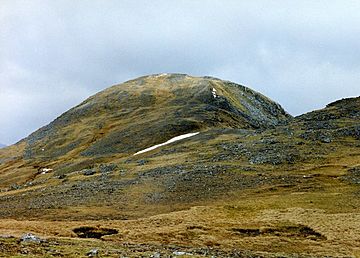
Sgùrr Thuilm is a cool mountain located in the Glenfinnan area of the Scottish Highlands. It stands at the top of Glen Finnan. This is about 7 kilometers (4.3 miles) north of Loch Shiel.
About Sgùrr Thuilm
Sgùrr Thuilm is a tall mountain, reaching 963 meters (3,159 feet) high. It is known as a Munro. A Munro is a Scottish mountain that is over 914.4 meters (3,000 feet) tall. Sgùrr Thuilm is also a Marilyn. This means it stands out a lot from the land around it. Its prominence is 614 meters (2,014 feet).
The mountain is at the start of Glen Finnan. People often climb it along with another nearby Munro called Sgùrr nan Coireachan. These two mountains are connected by a rocky ridge. Sgùrr Thuilm is close to an area called the Rough Bounds of Knoydart. It shares many features with the mountains there.
The name Sgùrr Thuilm comes from the Gaelic language. It means Rocky peak of the hillock.
What's the Geography Like?
Sgùrr Thuilm is a steep and rocky mountain. It is at the eastern end of a long, winding ridge. This ridge also includes Sgùrr nan Coireachan and other smaller peaks. This ridge forms a valley called Coire Thollaidh. The River Finnan starts its journey in this valley.
The north side of Sgùrr Thuilm is very craggy. It has several coires, which are bowl-shaped valleys. These valleys drop down towards Glen Pean. To the south and east, there is a narrow valley called Gleann Cuirnean. This valley separates Sgùrr Thuilm from Streap. Streap is another type of Scottish mountain called a Corbett.
Sgùrr Thuilm has three main ridges:
- The curved western ridge connects it to Sgùrr nan Coireachan.
- The northeastern ridge goes down into Glen Peann. It passes over a smaller peak called Meall an Fhir-eoin.
- The southwestern ridge is named Druim Coire a' Bheithe. It drops down to Glenfinnan Lodge.
How to Climb Sgùrr Thuilm
You can climb Sgùrr Thuilm from a few different places. One way is from Glen Finnan, which is to the south. Another way is from the northeast. This route starts near the public road at the west end of Loch Arkaig.
The path from Glen Finnan is a bit longer. But you can cycle part of the way up the glen.
If you start from the A830 road on the west side of the River Finnan, you follow Glen Finnan. Then you find a path used by stalkers. This path leads you up the southeast ridge of Sgùrr nan Coireachan. From the top of Sgùrr nan Coireachan, you walk east along a rough ridge. You will cross two smaller peaks to reach Sgùrr Thuilm. To go back to Glen Finnan, you can go down the south and then southwest side. This path is called Druim Coire a' Bheithe.
 | Shirley Ann Jackson |
 | Garett Morgan |
 | J. Ernest Wilkins Jr. |
 | Elijah McCoy |

