
Sharon Hill, Pennsylvania facts for kids
Quick facts for kids
Sharon Hill, Pennsylvania
|
|
|---|---|

Sharon Hill Public Library
|
|

Location in Delaware County and the U.S. state of Pennsylvania.
|
|

Sharon Hill, Pennsylvania
Location in Pennsylvania

Sharon Hill, Pennsylvania
Location in the United States
|
|
| Country | United States |
| State | Pennsylvania |
| County | Delaware |
| Area | |
| • Total | 0.77 sq mi (2.00 km2) |
| • Land | 0.77 sq mi (2.00 km2) |
| • Water | 0.00 sq mi (0.00 km2) |
| Elevation | 85 ft (26 m) |
| Population
(2010)
|
|
| • Total | 5,697 |
| • Estimate
(2019)
|
5,689 |
| • Density | 7,369.17/sq mi (2,846.46/km2) |
| Time zone | UTC-5 (EST) |
| • Summer (DST) | UTC-4 (EDT) |
| ZIP code |
19079
|
| Area code(s) | 610 and 484 |
| FIPS code | 42-045-69752 |
| FIPS code | 42-69752 |
| GNIS feature ID | 1187371 |
Sharon Hill is a friendly town located in Delaware County, Pennsylvania, in the United States. It's a place where many people live and learn. In 2010, about 5,697 people called Sharon Hill home. Today, even more people live here, with the population now around 6,356!
Contents
Exploring Sharon Hill
Where is Sharon Hill Located?
Sharon Hill is in the eastern part of Delaware County. It's surrounded by other towns like Folcroft to the west and Collingdale and Darby to the north. To the east, you'll find Colwyn, and to the south is Darby Township. The town covers about 2 square kilometers (0.77 square miles) of land.
Who Lives in Sharon Hill?
Sharon Hill is home to a diverse group of people. The population has changed over the years. In 1900, about 1,058 people lived here. By 2020, the population grew to 6,014 residents.
The community is made up of people from many different backgrounds. In 2010, about 32.6% of residents were White, and 60.6% were African American. There were also people of Native American, Asian, and other backgrounds. About 3.2% of the population was Hispanic or Latino.
Families are an important part of Sharon Hill. Many households have children under 18. The average household has about 2.61 people, and the average family has about 3.24 people. The median age in Sharon Hill is 36 years old.
Education and Learning
Schools in Sharon Hill
Students in Sharon Hill attend schools within the Southeast Delco School District. Younger students (Kindergarten to 8th grade) go to Sharon Hill School. All high school students in the district attend Academy Park High School.
In the past, there were also Catholic schools in Sharon Hill. Holy Spirit School closed in 2003, and Holy Child Academy closed in 1973.
For those looking for higher education, Delaware County Community College has a center nearby in the Folcroft East Business Park.
Places of Worship
The Roman Catholic Archdiocese of Philadelphia used to operate Holy Spirit Church in Sharon Hill. This church was established in 1892. However, it closed in 2015, and its community joined St. George Church in Glenolden.
Famous People from Sharon Hill
Many interesting people have connections to Sharon Hill!
- Rodney Blake is a professional basketball player.
- William Clothier was a tennis champion who won the U.S. Open in 1906. He is in the International Tennis Hall of Fame.
- Bert Cooper was a professional boxer.
- Bill Cubit is a college football coach.
- Jalen Duren is an NBA basketball player who was born in Sharon Hill. He lived here until he was in seventh grade.
- Cardinal John Patrick Foley was a member of the College of Cardinals.
- William H. Milliken, Jr. served as a U.S. Congressman for Pennsylvania.
- Bessie Smith, a famous blues singer, is buried at Mount Lawn Cemetery in Sharon Hill. Her grave was unmarked for many years until singer Janis Joplin and Juanita Green paid for a tombstone in 1970.
- Tammi Terrell was a well-known American singer-songwriter. She was famous for her songs with Motown Records, especially her duets with Marvin Gaye.
Getting Around Sharon Hill
_at_Clifton_Avenue_in_Sharon_Hill,_Delaware_County,_Pennsylvania.jpg)
Sharon Hill has a good road system. There are about 11.17 miles of public roads. Most of these roads are maintained by the borough itself.
U.S. Route 13, also known as Chester Pike, is the main road that goes through Sharon Hill. This road can take you northeast to Center City Philadelphia or southwest to Chester.

Public transportation is also available. The Media–Sharon Hill Line light rail connects Sharon Hill to the 69th Street Transportation Center in Upper Darby. You can catch a train at the Sharon Hill terminus. There are also SEPTA train stations, Curtis Park station and Sharon Hill station, on the regional rail Wilmington/Newark Line.
Images for kids
-
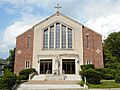
The new Holy Spirit Catholic Church, built in 1960, closed in 2015
-
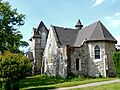
Old church near the 1960 Holy Spirit Catholic Church


See also
 In Spanish: Sharon Hill (borough) para niños
