
Shell River (Minnesota) facts for kids
Quick facts for kids Shell River |
|
|---|---|

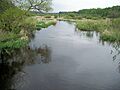
The Shell River in Straight River Township in 2007
|
|

Location of the mouth of the Shell River in Crow Wing Lake Township
|
|
| Country | United States |
| State | Minnesota |
| Physical characteristics | |
| Main source | Shell Lake Carsonville Township, Becker County 1,519 ft (463 m) 46°56′50″N 95°24′39″W / 46.94722°N 95.41083°W |
| River mouth | Crow Wing River Crow Wing Lake Township, Hubbard County 1,362 ft (415 m) 46°48′26″N 94°53′16″W / 46.80722°N 94.88778°W |
| Length | 47.8 mi (76.9 km) |
| Basin features | |
| Tributaries |
|
The Shell River is a river in north-central Minnesota, United States. It flows for about 47.8-mile-long (76.9 km). The Shell River is a tributary of the Crow Wing River.
The water from the Shell River eventually joins the Mississippi River. This means it is part of the large watershed of the Mississippi. The river flows through a mostly rural area.
The river got its name from the many mussel and clam shells found along its banks. These shells are also found in Shell Lake, where the river begins.
Contents
Where is the Shell River Located?
The Shell River starts at Shell Lake. This lake is about 3 miles (5 km) southwest of Pine Point. It is in Carsonville Township in eastern Becker County.
Shell River's Journey Through Minnesota
The river first flows southeast. It goes through the Smoky Hills State Forest. Then it enters southwestern Hubbard County and northwestern Wadena County.
The Shell River reaches Blueberry Lake, where it collects water from the Blueberry River. From Blueberry Lake, the Shell River turns eastward. It winds its way through northern Wadena and southern Hubbard counties.
The river also passes through Huntersville State Forest. Along its path, it collects water from the Fish Hook River from the north.
Where Does the Shell River End?
The Shell River flows into the Crow Wing River. This meeting point is in Crow Wing Lake Township in Hubbard County.
The Shell River is the first major river that joins the Crow Wing River. It is actually much larger than the Crow Wing River at their meeting point. The Shell River's average flow is about 250 cubic feet per second (7 m³/s). This is about three times more water than the Crow Wing River carries before they meet.
What is the Shell River's Environment Like?
The Shell River is located in the Northern Lakes and Forests ecoregion. This area has many conifer (like pine trees) and hardwood (like oak trees) forests. The land is made up of flat and rolling till plains and outwash plains.
Fun Activities on the Shell River
You can go canoeing on the lower part of the river, below Blueberry Lake. It's a great place for sport fishing. Many northern pike live in the river, making it a popular spot for anglers.
Shells and History Along the River
There are many clams on the river bottom. Long ago, there was a community called Shell City in Shell River Township. This town had a factory that used clam shells to make buttons for clothing.
Images for kids
-
The Shell River in Straight River Township in 2007
