
Sherwood, Nottingham facts for kids
Quick facts for kids Sherwood |
|
|---|---|

Sherwood
|
|
| Population | 15,414 (Ward.201) |
| OS grid reference | SK 57329 43115 |
| Unitary authority | |
| Ceremonial county | |
| Region | |
| Country | England |
| Sovereign state | United Kingdom |
| Post town | NOTTINGHAM |
| Postcode district | NG5 |
| Dialling code | 0115 |
| Police | Nottinghamshire |
| Fire | Nottinghamshire |
| Ambulance | East Midlands |
| EU Parliament | East Midlands |
| UK Parliament |
|
Sherwood is a lively area and a special part of the city of Nottingham in England. It's located about 1.5 miles (2.4 km) north of the city center. In 2011, about 15,414 people lived here. Sherwood is surrounded by other neighborhoods like Woodthorpe, Mapperley, Carrington, Basford, Daybrook, and Bestwood.
It's important not to confuse this Sherwood with the famous Sherwood Forest. Sherwood Forest, the Sherwood parliamentary area, and the Newark and Sherwood council district are all located several miles north of the city.
Contents
A Look Back: Sherwood's History
Sherwood grew a lot between 1870 and 1910. This was when the lace industry was booming. You can still see old carved stones on buildings from this time. Many of these buildings are now protected because they are so old and important.
The Sherwood Bus Depot was built in 1900. It was first used for trams by the Nottingham Corporation Tramways. Trams ran on this route until 1936, when buses took over. Today, part of the old depot is a pub called the Samuel Hall. Another part is a community center called 'The Place Activity Centre'.
Famous Faces from Sherwood
- Julia Bell (1879–1979) was a geneticist, a scientist who studies how traits are passed down through families. She was born right here in Sherwood.
Exploring Sherwood's Amenities
Sherwood has many useful places for its residents.
Schools and Learning
There are two primary schools in Sherwood for younger students. Seely Primary and Nursery School is on Perry Road. Haydn Primary School is located on Haydn Road. Nottingham Free School is also on Haydn Road, though it is technically in a nearby area.
Public Services and Safety
Nottingham Prison and Young Offenders' Institute is located on Perry Road.
A police station opened in Sherwood in 2007. This helped local police be more visible in the area. It also helped reduce crime. However, the station closed a few years later to save money. Now, only a police contact center next to the library remains.
Shopping and Fun
The main shopping area in Sherwood is along Mansfield Road. This road is usually very busy! You can find well-known stores like Boots and Wilko here. There are also charity shops, restaurants, and many local businesses. These include newsagents, butchers, dentists, and hairdressers. You can also find several pubs.
The Jason Spencer Sports Ground was built in 2011. It was named after a local teenager, Jason Spencer, following a tragic event. This sports ground has a basketball court, an outdoor gym, and a skate park. It's a great place for outdoor activities.
Community Hubs
The Sherwood Community Centre is at the northern end of Mansfield Road. It's a busy place where many local groups meet. You can find activities like adult ballet, yoga, and Zumba classes here.
Sherwood Library is on the corner of Mansfield Road and Spondon Street. The library often hosts fun community events for everyone.
Sherwood also has several churches. These include St Martin's Church, Sherwood Methodist Church, and United Reformed Church.
Getting Around Sherwood: Bus Services
Sherwood has excellent bus connections. Several bus routes run through the area. These buses connect Sherwood to Nottingham city centre and other parts of the city. The main road, the A60 road, helps buses travel easily into Nottingham.
Nottingham City Transport
- 15: Nottingham – Hucknall Road (Sherwood) – City Hospital – Rise Park
- 16: Nottingham – Hucknall Road (Sherwood) – City Hospital – Top Valley – Rise Park
- 17: Nottingham – Hucknall Road (Sherwood) – City Hospital – Bulwell
- 40: Nottingham – St Ann's – Sherwood – City Hospital
- 56: Nottingham – Sherwood – Plains Estate – Arnold
- 57: Nottingham – Sherwood – Plains Estate
- 58: Nottingham – Sherwood – Arnold – Killisick
- 59: Nottingham – Sherwood – Arnold – Killisick
- 87: Nottingham – Sherwood – City Hospital – Redhill – Arnold
- 88: Nottingham – Sherwood – City Hospital – Top Valley – Rise Park
- 89: Nottingham – Sherwood – City Hospital – Rise Park
Trent Barton
- The Calverton: Nottingham – Sherwood – Arnold – Calverton (some buses go to Oxton and Epperstone)
- The Threes: Nottingham – Hucknall Road (Sherwood) – City Hospital – Hucknall
Stagecoach East Midlands
- Pronto: Nottingham – Sherwood – Mansfield – Chesterfield
- Sherwood Arrow: Nottingham – Sherwood – New Ollerton
Images for kids
-
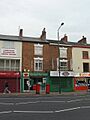
Sherwood Post Office in 2009 (it has moved since then)
-
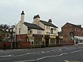
The Sherwood Inn
-
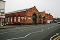
Sherwood Bus Depot from Mansfield Road


