Shickshinny Creek facts for kids
Quick facts for kids Shickshinny Creek |
|
|---|---|

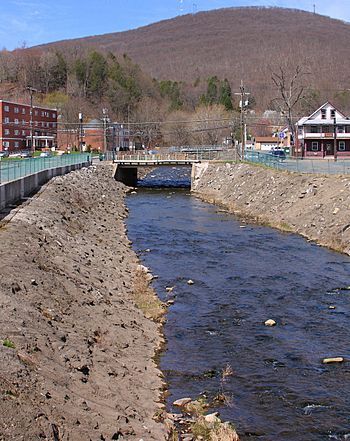
Shickshinny Creek in Shickshinny
|
|
| Other name(s) | Shickohinna |
| Physical characteristics | |
| Main source | valley northwest of Sylvan Lake in Ross Township, Luzerne County, Pennsylvania between 1,200 and 1,220 feet (370 and 370 m) |
| River mouth | Susquehanna River in Shickshinny, Luzerne County, Pennsylvania 499 ft (152 m) ACoordinates: Unknown argument format |
| Length | 10.1 mi (16.3 km) |
| Basin features | |
| Progression | Susquehanna River → Chesapeake Bay |
| Basin size | 35.0 sq mi (91 km2) |
| Tributaries |
|
Shickshinny Creek is a cool stream in Luzerne County, Pennsylvania, in the United States. It's like a smaller river that flows into a bigger one, the Susquehanna River. The creek is about 10.1 miles (16.3 km) long. It flows through three areas: Ross Township, Union Township, and the town of Shickshinny.
The land area that drains into Shickshinny Creek, called its watershed, is about 35.0 square miles (91 km2). Other smaller streams, called tributaries, join it. These include Culver Creek, Reyburn Creek, and Little Shickshinny Creek. Shickshinny Creek is a special place for fish, as it's known as a Coldwater Fishery and a Migratory Fishery. This means it's cold enough for certain fish and they can travel through it.
Long ago, people built mills on the creek. A sawmill was built in 1802, and a gristmill (for grinding grain) in 1804. Many bridges also cross the creek today. In the past, the creek had some pollution from coal waste near its end. But farming was the main activity in the area in the early 1900s. People also used the creek as a source of water.
The ground around Shickshinny Creek has different types of soil and rock. You can find urban land, areas filled with dirt, and natural river deposits. The lower part of the creek flows through a narrow valley between Huntington Mountain and Shickshinny Mountain. There's also a lake called Shickshinny Lake in the area, which has a dam.
Contents
The Creek's Journey

Shickshinny Creek starts in a valley in Ross Township, which is northwest of Sylvan Lake. It flows south for a few miles, passing through two ponds. Then it turns southwest and enters Union Township.
The creek continues its journey through a valley called Nevel Hollow. After Nevel Hollow, it flows into Shickshinny Lake. Here, another stream called Culver Creek joins it from the right side. From the lake, Shickshinny Creek flows southeast through another valley.
Eventually, the creek turns south and then east for a short bit. Reyburn Creek, another tributary, joins it from the left. The creek then flows south through the village of Koonsville. It passes between Huntington Mountain and Shickshinny Mountain in a narrow gap.
Finally, Shickshinny Creek enters the town of Shickshinny. Here, Little Shickshinny Creek joins it from the right. The creek flows through Shickshinny town and then meets the big Susquehanna River. Shickshinny Creek joins the Susquehanna River about 172.34 miles (277.35 km) before the Susquehanna reaches its own mouth.
Streams Joining Shickshinny Creek
Shickshinny Creek has three main streams that flow into it. These are Little Shickshinny Creek, Reyburn Creek, and Culver Creek.
- Little Shickshinny Creek joins Shickshinny Creek very close to its end, about 0.46 miles (0.74 km) upstream. The area that drains into Little Shickshinny Creek is about 9.80 square miles (25.4 km2).
- Reyburn Creek joins about 1.68 miles (2.70 km) upstream from the mouth of Shickshinny Creek. Its drainage area is about 9.52 square miles (24.7 km2).
- Culver Creek joins Shickshinny Creek further upstream, about 6.72 miles (10.81 km) from its mouth. Its drainage area is smaller, around 1.10 square miles (2.8 km2).
Water and Weather
Shickshinny Creek's water is not very alkaline, meaning it's not very basic. In April 1965, scientists measured how much water was flowing in the creek at Shickshinny. It was about 65 cubic feet per second. The water temperature in late April 1965 was measured at 11.0 °C (51.8 °F).
In the early 1900s, Shickshinny Creek was mostly clear. However, near its mouth, some coal waste from a company drained into it. This caused the creek to add some coal waste to the Susquehanna River. Today, the creek is much cleaner.
The average yearly rainfall in the area is between 35 inches (89 cm) and 45 inches (110 cm). This rain helps keep the creek flowing.
Land and Rocks Around the Creek
The place where Shickshinny Creek meets the Susquehanna River is about 499 feet (152 m) above sea level. Where the creek starts, its elevation is much higher, between 1,200 and 1,220 feet (370 and 370 m) above sea level. This means the water flows downhill quite a bit! In its first mile, the creek drops about 160 feet (49 m).
The creek's path is curvy, not straight. It flows through different types of rocks, mostly sandstone and shale. In its lower parts, it goes through a narrow gorge for about a mile.
The mountains around Shickshinny Creek, like Shickshinny Mountain, have interesting rock layers. For example, there are layers of gray sandstone and brownish sandy shales. The Mauch Chunk Formation is also found in the area.
The ground near the creek changes along its path. Near the mouth, you'll find areas with buildings and disturbed land, along with river deposits. There are also signs of ancient glaciers, like sand and gravel left behind. In the middle parts of the creek, you'll see more bedrock (the solid rock under the soil) and glacial till (rock and soil left by glaciers). Upstream, near where the creek starts, it's mostly glacial till, bedrock, and some lakes.
The area that drains into Little Shickshinny Creek is part of the Wyoming Coal Basin. This means there are coal deposits underground. The Shickshinny Creek area is also part of the Wyoming Valley.
The Creek's Drainage Area
The total area that drains water into Shickshinny Creek, its watershed, is 35.0 square miles (91 km2). This area is mostly in the northwestern part of Luzerne County and a small part of Columbia County. The mouth of the creek is in the Shickshinny area, while its source is in the Sweet Valley area.
The lower parts of the watershed are mostly mountains. The upper parts have hills, swamps, and lakes. Two communities, Muhlenburg and Shickshinny, are located within the creek's watershed.
Shickshinny Lake is a notable feature in the watershed. It covers about 129 acres (52 ha). A dam, called the Shickshinny Lake Dam, holds back the lake's water. The dam is 365 feet (111 m) long and 33 feet (10 m) high. In 1980, an inspection found that the dam was generally okay, but needed some improvements to its spillway (where excess water flows out).
Shickshinny Creek can cause flooding in Union Township and Shickshinny. During a big flood in June 1972, the creek's water rose about 2 feet (0.61 m) above a road in Koonsville.
History and Name of the Creek
Shickshinny Creek was officially added to the Geographic Names Information System in 1979. The exact meaning of its name isn't fully known. But it might come from an old word, Schigi-hanna, which means "fine creek."
In the early 1800s, people started building mills on the creek. The first sawmill in Union Township was built by Isaac Benscotter in 1802. George Gregory built the first gristmill in 1804. Later, in 1858, the Search brothers built several mills on the creek, including a sawmill, a flour mill, and a brickyard. These were known as the Shickshinny Mills.
A special road called a turnpike was built through the Shickshinny Creek gap in 1877. Many bridges have been built over the creek over the years. For example, a stone bridge carrying Glen Ave is 32.2 feet (9.8 m) long. Several concrete and steel bridges were built in the 1920s, 1930s, and 1960s to carry roads like Pennsylvania Route 239 and State Route 4007 over the creek.
In the early 1900s, the Shickshinny Water Company used a stream in the creek's watershed for water supply. Little Shickshinny Creek also provided water for the towns of Shickshinny and Mocanaqua. Agriculture was a very important activity in the watershed in the past. The streams also powered small mills.
In 1996, some oil leaked into Shickshinny Creek from a pipe. Luckily, there wasn't much harm to the environment.
Animals and Plants
Shickshinny Creek is a special place for fish. It's known as a Coldwater Fishery and a Migratory Fishery. This means the water is cold enough for certain types of fish to live there, and they can travel through it. Wild trout naturally live and reproduce in Shickshinny Creek, from where it starts all the way to its mouth.
Some of the smaller streams that flow into Shickshinny Creek, like Reyburn Creek and Culver Creek, also have these special designations. Little Shickshinny Creek is even more special; it's called a High-Quality Coldwater Fishery and a Migratory Fishery.
The area around Little Shickshinny Creek is listed in the Columbia County Natural Areas Inventory because it has important habitats. These include forests with hemlock trees, red maple swamps, dry oak forests, and areas with highbush blueberry shrubs. There's also a reservoir nearby.
 | William M. Jackson |
 | Juan E. Gilbert |
 | Neil deGrasse Tyson |


