Shiloh, New Jersey facts for kids
Quick facts for kids
Shiloh, New Jersey
|
||
|---|---|---|
|
Borough
|
||

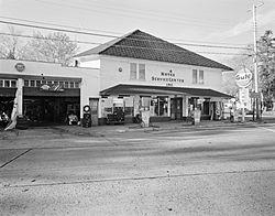
Noyes Service Center in 1992
|
||
|
||

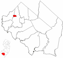
Location of Shiloh in Cumberland County highlighted in red (right). Inset map: Location of Cumberland County in New Jersey highlighted in red (left).
|
||

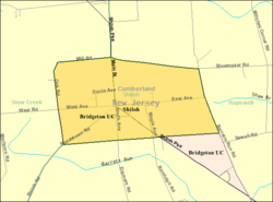
Census Bureau map of Shiloh, New Jersey
|
||
| Country | ||
| State | ||
| County | Cumberland | |
| Incorporated | April 9, 1929 | |
| Government | ||
| • Type | Borough | |
| • Body | Borough Council | |
| Area | ||
| • Total | 1.20 sq mi (3.12 km2) | |
| • Land | 1.20 sq mi (3.12 km2) | |
| • Water | 0.00 sq mi (0.00 km2) 0.08% | |
| Area rank | 486th of 565 in state 14th of 14 in county |
|
| Elevation | 112 ft (34 m) | |
| Population
(2020)
|
||
| • Total | 444 | |
| • Estimate
(2023)
|
443 | |
| • Rank | 556th of 565 in state 14th of 14 in county |
|
| • Density | 369.0/sq mi (142.5/km2) | |
| • Density rank | 462nd of 565 in state 4th of 14 in county |
|
| Time zone | UTC−05:00 (Eastern (EST)) | |
| • Summer (DST) | UTC−04:00 (Eastern (EDT)) | |
| ZIP Code |
08353
|
|
| Area code(s) | 856 exchanges: 451, 455 | |
| FIPS code | 3401167020 | |
| GNIS feature ID | 0885393 | |
| Website | ||
Shiloh is a small town, known as a borough, located in Cumberland County, New Jersey. It is part of the larger Vineland–Bridgeton area. In 2020, the town had a population of 444 people.
Shiloh became an official borough on April 9, 1929. This happened after people voted to separate it from parts of Hopewell Township and Stow Creek Township.
It is also known as a "dry town." This means that, by law, alcohol is generally not sold here. However, there is a winery in the borough where alcohol is available.
Contents
History of Shiloh
The first settlement in Shiloh began in 1705. A person named Robert Ayars led over 2,000 Seventh Day Baptists from Rhode Island to this area. They came here to find freedom from religious persecution.
The area was first called Cohansey Crossing. This name was used when a church was built in 1737. The name Shiloh was adopted in 1771. Some sources say the town was named after the Civil War Battle of Shiloh.
When Cumberland County, New Jersey was created in 1748, Shiloh was split between two townships: Hopewell Township and Stow Creek Township.
For a short time, from 1844 to 1845, Shiloh was part of a new area called Columbia Township. This was due to a political disagreement about where the county's main government office should be. However, Columbia Township was soon dissolved, and Shiloh returned to its original townships.
Geography and Location
Shiloh is a small borough with a total area of about 1.20 square miles (3.12 square kilometers). Almost all of this area is land, with very little water.
Shiloh shares its borders with two other townships:
Population Changes
| Historical population | |||
|---|---|---|---|
| Census | Pop. | %± | |
| 1930 | 401 | — | |
| 1940 | 387 | −3.5% | |
| 1950 | 427 | 10.3% | |
| 1960 | 554 | 29.7% | |
| 1970 | 573 | 3.4% | |
| 1980 | 604 | 5.4% | |
| 1990 | 408 | −32.5% | |
| 2000 | 534 | 30.9% | |
| 2010 | 516 | −3.4% | |
| 2020 | 444 | −14.0% | |
| 2023 (est.) | 443 | −14.1% | |
| Population sources:1930–2010 1930 1940–2000 2000 2010 2020 |
|||
Population in 2010
The 2010 United States census showed that 516 people lived in Shiloh. There were 198 households, with 138 of them being families. The town had about 427 people per square mile.
Most of the residents, about 93.8%, were White. About 1.7% were Black or African American, and 2.3% were Native American. About 4% of the population identified as Hispanic or Latino.
- About 27.8% of households had children under 18.
- More than half (51%) were married couples.
- About 12.1% of households had someone living alone who was 65 or older.
The average age in Shiloh in 2010 was 42 years old.
Education for Students
Students in Shiloh attend public schools in nearby districts.
Elementary and Middle School
After Shiloh School closed in 2007, students in kindergarten through eighth grade now go to Hopewell Crest School. This is part of an agreement with the Hopewell Township School District.
High School Education
Students in ninth through twelfth grade attend Cumberland Regional High School. This high school also serves students from several other nearby townships.
Shiloh has one representative on the high school's board of education. This board helps make decisions for the school.
Students can also attend the Cumberland County Technical Education Center in Vineland. This center offers technical training programs for students from across the county. These programs are free for county residents.
Transportation in Shiloh
As of 2010, Shiloh had about 5.84 miles of roads.
- The town itself maintained 1.54 miles of these roads.
- Cumberland County maintained 3.17 miles.
- The New Jersey Department of Transportation maintained 1.13 miles.
Route 49, also known as Shiloh Pike, runs through the borough. It connects Shiloh to Hopewell Township and Stow Creek Township.
Local Winery
- Swansea Vineyards is a winery located in Shiloh.
See also
 In Spanish: Shiloh (Nueva Jersey) para niños
 | Misty Copeland |
 | Raven Wilkinson |
 | Debra Austin |
 | Aesha Ash |


