Shire of Cloncurry facts for kids
Quick facts for kids Shire of CloncurryQueensland |
|||||||||||||||
|---|---|---|---|---|---|---|---|---|---|---|---|---|---|---|---|

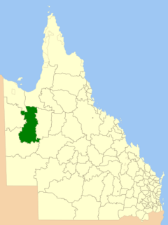
Location within Queensland
|
|||||||||||||||
| Population | 3,644 (2021 census) | ||||||||||||||
| • Density | 0.075963/km2 (0.19674/sq mi) | ||||||||||||||
| Established | 1884 | ||||||||||||||
| Area | 47,971 km2 (18,521.7 sq mi) | ||||||||||||||
| Mayor | Greg Campbell | ||||||||||||||
| Council seat | Cloncurry | ||||||||||||||
| Region | North West Queensland | ||||||||||||||
| State electorate(s) | Traeger | ||||||||||||||
| Federal Division(s) | Kennedy | ||||||||||||||
 |
|||||||||||||||
| Website | Shire of Cloncurry | ||||||||||||||
|
|||||||||||||||
The Shire of Cloncurry is a special area in North West Queensland, Australia. It has its own local government, which helps manage the area. This shire is very large, covering about 47,971 square kilometers. It has been a local government area since 1884. The main town and center of the shire is Cloncurry.
Before Europeans arrived, the land was home to the Mitakoodi, Kalkadoon, and Pitta Pitta Aboriginal people.
The town of Mary Kathleen is also in the shire. It used to be a busy town because of a uranium mine. But the mine is now closed, and Mary Kathleen is a "ghost town."
In 2021, about 3,644 people lived in the Shire of Cloncurry.
Contents
Exploring the History of Cloncurry Shire
Aboriginal Languages and Heritage
The land of the Shire of Cloncurry has a rich history. It is part of the traditional lands of several Aboriginal language groups.
- The Wanamarra language, also called Maykulan or Wunumura, is spoken in parts of North West Queensland. This includes areas within the Shire of Cloncurry.
- The Yulluna language, also known as Yalarnga or Jalanga, is another Aboriginal language. It is spoken in the Gulf Country, including the Shire of Cloncurry.
Early European Exploration
The first Europeans to visit this area were explorers Wills and Burke in 1861. Burke named the Cloncurry River after his cousin. Later, in 1867, Ernest Henry came to the area looking for land for animals to graze. Instead, he discovered copper! He is seen as the founder of the town because of his discovery.
The town was officially named Cloncurry in 1876. It is known for being a place where new ideas started. For example, Qantas, a famous airline, began its flights here. Also, the Royal Flying Doctor Service, which provides medical help to people in remote areas, started in Cloncurry in 1928.
How the Shire Was Formed
The way local governments are set up has changed over time.
- In 1879, a large area called the Doonmunya Division was created. It was very big and had few people.
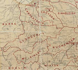
- Because it was so big, it was hard to manage. So, in 1883, the Doonmunya Division was replaced by the Carpentaria Division.
- People living near Cloncurry found it difficult to travel to Normanton, the main town of the Carpentaria Division. They wanted their own local government.
- So, in 1884, a part of the Carpentaria Division was separated. This new area became the Cloncurry Division.
- In 1885, more changes were made to the boundaries. The Burke Division was also created from the Carpentaria Division.
- Finally, on March 31, 1903, the Cloncurry Division officially became the Shire of Cloncurry.
Mining in the Shire
Mining has always been very important for the growth of the Cloncurry region. It helped the area develop and create jobs. There are still several active mines in the shire today. Some mines have been closed, like the Lady Fanny mine in Kuridala. However, some abandoned mines are being looked at again to see if they still have valuable minerals.
Community Services
Public Library
The Cloncurry Shire Council runs a public library in Cloncurry. Libraries are great places to read, learn, and find information.
Towns and Localities
The Shire of Cloncurry includes several towns and smaller communities. These are:
- Cloncurry
- Dajarra
- Dobbyn
- Duchess
- Four Ways
- Kajabbi
- Kuridala
- Malbon
- Mount Cuthbert
- Selwyn
- The Monument
- Three Rivers
Population Changes Over Time
The number of people living in the Shire of Cloncurry has changed quite a bit over the years. Here's a look at the population at different times:
| Year | Population | Notes |
|---|---|---|
| 1933 | 6,184 | |
| 1947 | 6,267 | |
| 1954 | 3,052 | |
| 1961 | 4,869 | |
| 1966 | 3,348 | |
| 1971 | 3,623 | |
| 1976 | 4,036 | |
| 1981 | 3,651 | |
| 1986 | 3,194 | |
| 1991 | 3,382 | |
| 1996 | 3,878 | |
| 2001 census | 4,797 | |
| 2006 census | 3,138 | |
| 2011 census | 3,229 | |
| 2016 census | 3,032 | |
| 2021 census | 3,644 |
Leaders of the Shire
The Shire of Cloncurry has had different leaders over the years. These leaders are called Chairmen or Mayors. They help make decisions for the community.
- 1884: George Seymour
- 1919: J. Hedleffe
- 1927: Walter Angus Rose
- 2008–2016: Andrew Daniels
- 2016: Gregory Vincent (Greg) Campbell
One notable person who was part of the council was Tom Aikens. He was a deputy chairman from 1927 to 1930. He later became a Member of the Queensland Legislative Assembly, representing areas like Munndingburra and Townsville South.
 | Victor J. Glover |
 | Yvonne Cagle |
 | Jeanette Epps |
 | Bernard A. Harris Jr. |


