
Shoshone, Idaho facts for kids
Quick facts for kids
Shoshone, Idaho
|
|
|---|---|

American Legion Hall, Shoshone
|
|

Location of Shoshone in Lincoln County, Idaho.
|
|
| Country | United States |
| State | Idaho |
| County | Lincoln |
| Founded | 1882, 144 years ago |
| Area | |
| • Total | 1.20 sq mi (3.10 km2) |
| • Land | 1.17 sq mi (3.04 km2) |
| • Water | 0.02 sq mi (0.06 km2) |
| Elevation | 3,963 ft (1,208 m) |
| Population
(2020)
|
|
| • Total | 1,653 |
| • Density | 1,280.48/sq mi (494.23/km2) |
| Time zone | UTC-7 (Mountain (MST)) |
| • Summer (DST) | UTC-6 (MDT) |
| ZIP codes |
83324, 83352
|
| Area code(s) | 208, 986 |
| FIPS code | 16-73900 |
| GNIS feature ID | 2411894 |
Shoshone is the main city and county seat of Lincoln County, Idaho. Its population was 1,653 people in 2020. Even though it sounds like the Shoshone Native American tribe, the city's name is pronounced "Show-shown." The "e" at the end is silent.
Contents
Discovering Shoshone's Past
Shoshone was founded in 1882. This happened during the building of the Oregon Short Line railroad. For a long time, Shoshone was the most important railroad station in the Magic Valley area of south central Idaho.
Shoshone's Railroad Importance
The larger city of Twin Falls, about 26 miles south, never had a strong railroad presence. This was because of the Snake River Canyon, which made it hard to build tracks there. For many years, Shoshone was the only place in south central Idaho where the Amtrak train stopped.
Connecting to Sun Valley
The Union Pacific Railroad opened the Sun Valley resort in 1936. They already had a special train route that connected to Ketchum. This route started in Shoshone. It went northeast towards Richfield and then northwest to places like Picabo and Hailey, ending in Ketchum.
Exploring Shoshone Ice Caves
About 15 miles north of Shoshone, you can find the Shoshone Ice Caves. These caves are actually lava tubes. They stay so cold that the ice inside them remains frozen all summer long. Before refrigerators existed, these caves and the railroad made Shoshone famous. It was known as the only place for hundreds of miles where you could get a cold drink!
Shoshone's Economy and Community
Today, Shoshone is a small town with a few local businesses. It has a bar, a cafe, a movie theater, and a grocery store. This is quite a lot for a town its size!
Farming and Local Services
Shoshone is mainly a farming and dairy community. This means many people work in agriculture. The town also has a Bureau of Land Management (BLM) office. There is a small medical clinic and a new school building for students from kindergarten to 12th grade.
A Growing "Bedroom Community"
In recent years, Shoshone has become a "bedroom community." This means people live in Shoshone because it's more affordable. They then travel to work in nearby Blaine County. Resort cities like Ketchum and Sun Valley are about an hour north. This trend has helped Shoshone grow. The town also has some interesting historical buildings.
Shoshone's Geography
Shoshone covers about 1.16 square miles. Most of this area is land, and a small part is water. The Little Wood River flows right through the town.
Land Features and Challenges
Much of the land around Shoshone is made of lava rock. This can make it difficult to dig for building projects. It also limits how much land can be used for farming.
Shoshone's Climate
Shoshone has a cold semi-arid climate. This means it's generally dry, but it can get quite cold.
| Climate data for Shoshone, Idaho, 1991–2020 normals, extremes 1908–present | |||||||||||||
|---|---|---|---|---|---|---|---|---|---|---|---|---|---|
| Month | Jan | Feb | Mar | Apr | May | Jun | Jul | Aug | Sep | Oct | Nov | Dec | Year |
| Record high °F (°C) | 60 (16) |
65 (18) |
79 (26) |
90 (32) |
101 (38) |
105 (41) |
109 (43) |
105 (41) |
104 (40) |
93 (34) |
77 (25) |
67 (19) |
109 (43) |
| Mean maximum °F (°C) | 45.6 (7.6) |
52.6 (11.4) |
67.3 (19.6) |
78.5 (25.8) |
88.5 (31.4) |
96.3 (35.7) |
102.4 (39.1) |
100.4 (38.0) |
93.4 (34.1) |
81.3 (27.4) |
63.4 (17.4) |
48.1 (8.9) |
103.0 (39.4) |
| Mean daily maximum °F (°C) | 37.2 (2.9) |
43.0 (6.1) |
54.5 (12.5) |
63.5 (17.5) |
73.8 (23.2) |
84.0 (28.9) |
94.1 (34.5) |
92.4 (33.6) |
81.4 (27.4) |
65.9 (18.8) |
49.5 (9.7) |
37.7 (3.2) |
64.8 (18.2) |
| Daily mean °F (°C) | 30.2 (−1.0) |
34.6 (1.4) |
43.6 (6.4) |
50.8 (10.4) |
60.2 (15.7) |
68.8 (20.4) |
77.9 (25.5) |
76.2 (24.6) |
66.1 (18.9) |
53.1 (11.7) |
40.3 (4.6) |
30.7 (−0.7) |
52.7 (11.5) |
| Mean daily minimum °F (°C) | 23.3 (−4.8) |
26.1 (−3.3) |
32.7 (0.4) |
38.2 (3.4) |
46.7 (8.2) |
53.5 (11.9) |
61.7 (16.5) |
59.9 (15.5) |
50.9 (10.5) |
40.2 (4.6) |
31.1 (−0.5) |
23.8 (−4.6) |
40.7 (4.8) |
| Mean minimum °F (°C) | 1.5 (−16.9) |
6.8 (−14.0) |
15.4 (−9.2) |
22.3 (−5.4) |
29.9 (−1.2) |
36.9 (2.7) |
46.6 (8.1) |
44.6 (7.0) |
33.8 (1.0) |
22.1 (−5.5) |
11.5 (−11.4) |
2.6 (−16.3) |
−3.4 (−19.7) |
| Record low °F (°C) | −36 (−38) |
−35 (−37) |
−11 (−24) |
1 (−17) |
15 (−9) |
27 (−3) |
32 (0) |
29 (−2) |
16 (−9) |
8 (−13) |
−20 (−29) |
−27 (−33) |
−36 (−38) |
| Average precipitation inches (mm) | 1.57 (40) |
0.90 (23) |
1.14 (29) |
0.81 (21) |
1.07 (27) |
0.56 (14) |
0.16 (4.1) |
0.30 (7.6) |
0.46 (12) |
0.76 (19) |
1.02 (26) |
1.72 (44) |
10.47 (266.7) |
| Average snowfall inches (cm) | 4.2 (11) |
3.3 (8.4) |
0.8 (2.0) |
0.0 (0.0) |
0.0 (0.0) |
0.0 (0.0) |
0.0 (0.0) |
0.0 (0.0) |
0.0 (0.0) |
0.0 (0.0) |
2.2 (5.6) |
5.7 (14) |
16.2 (41) |
| Average precipitation days (≥ 0.01 in) | 7.8 | 6.5 | 6.7 | 6.7 | 5.8 | 3.7 | 1.3 | 1.9 | 3.0 | 4.4 | 5.8 | 7.9 | 61.5 |
| Average snowy days (≥ 0.1 in) | 2.5 | 1.7 | 0.4 | 0.0 | 0.0 | 0.0 | 0.0 | 0.0 | 0.0 | 0.0 | 1.1 | 2.5 | 8.2 |
| Source 1: NOAA | |||||||||||||
| Source 2: National Weather Service (snow/snow days 1981–2010) | |||||||||||||
Highways Connecting Shoshone
Several important highways meet in Shoshone. These include:
 - US 26
 - US 93
 - SH-24
 - SH-75 - Sawtooth Scenic Byway
Shoshone is the southern end of Highway 75. Because of this, traffic between the Magic Valley and Sun Valley often passes through Shoshone. This helps the town keep its old role as a place for travelers to stop and rest.
Shoshone's Population and People
| Historical population | |||
|---|---|---|---|
| Census | Pop. | %± | |
| 1910 | 1,155 | — | |
| 1920 | 1,165 | 0.9% | |
| 1930 | 1,211 | 3.9% | |
| 1940 | 1,366 | 12.8% | |
| 1950 | 1,420 | 4.0% | |
| 1960 | 1,416 | −0.3% | |
| 1970 | 1,233 | −12.9% | |
| 1980 | 1,242 | 0.7% | |
| 1990 | 1,249 | 0.6% | |
| 2000 | 1,398 | 11.9% | |
| 2010 | 1,461 | 4.5% | |
| 2020 | 1,653 | 13.1% | |
| U.S. Decennial Census | |||
Population in 2010
In 2010, Shoshone had 1,461 people living there. There were 542 households and 349 families. The city had about 1,281 people per square mile.
Most residents (81%) were White. About 14.5% were from other races. About 29.4% of the population identified as Hispanic or Latino.
Many households (38.4%) had children under 18. About 48.3% were married couples. The average household had 2.63 people. The average family had 3.29 people.
The average age in Shoshone was 33 years old. About 29.4% of residents were under 18. About 15.7% were 65 or older. The population was almost evenly split between males (48.5%) and females (51.5%).
Education in Shoshone
The local school system is called Shoshone School District. It serves all the students in the area.
Famous People from Shoshone
- Jack M. Murphy (1925-1984) - He was an American politician. He served as the 32nd lieutenant governor of Idaho.
- Tim Ridinger - He is an American politician. He used to be the mayor of Shoshone. He also served in the Idaho House of Representatives.
Images for kids
-
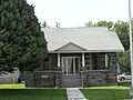
American Legion Hall, Shoshone
-
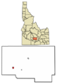
Location of Shoshone in Lincoln County, Idaho.
See also
 In Spanish: Shoshone (Idaho) para niños
