Silver Bow County, Montana facts for kids
Quick facts for kids
Silver Bow County
|
|
|---|---|
|
Consolidated city-county
|
|
| Butte-Silver Bow County | |

|
|

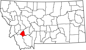
Location within the U.S. state of Montana
|
|
 Montana's location within the U.S. |
|
| Country | |
| State | |
| Founded | February 16, 1881 |
| Named for | Silver Bow Creek |
| Seat | Butte |
| Largest city | Butte |
| Area | |
| • Total | 719 sq mi (1,860 km2) |
| • Land | 718 sq mi (1,860 km2) |
| • Water | 0.6 sq mi (2 km2) 0.08% |
| Population
(2020)
|
|
| • Total | 35,133 |
| • Estimate
(2022)
|
36,068 |
| • Density | 48.86/sq mi (18.866/km2) |
| Time zone | UTC−7 (Mountain) |
| • Summer (DST) | UTC−6 (MDT) |
| Congressional district | 1st |
|
|
Silver Bow County is a special kind of area called a county in the state of Montana. It's located in the western part of the United States. In 2020, about 35,133 people lived here.
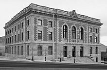
The main town and center of the county is Butte. In 1977, the city of Butte and Silver Bow County decided to join their governments. This created one big government called Butte-Silver Bow. This means they work together as one unit. There's also a smaller town called Walkerville within the county.
Silver Bow County is part of a larger area known as the Butte-Silver Bow, MT Micropolitan Statistical Area. This area includes Butte and its nearby communities.
Contents
Exploring Silver Bow County's Geography
Silver Bow County covers an area of about 719 square miles. Most of this is land, with only a tiny bit of water. It is actually the smallest county in Montana when you look at its size.
Main Roads and Highways
Many important roads run through Silver Bow County. These highways help people travel to and from the area.
Getting Around: Transit Options
If you need to travel longer distances, there are bus services available.
- Jefferson Lines
- Salt Lake Express
Neighboring Counties
Silver Bow County shares its borders with several other counties in Montana.
- Deer Lodge County is to the northwest.
- Jefferson County is to the east.
- Madison County is to the south.
- Beaverhead County is to the southwest.
Nature's Beauty: Protected Areas
Part of the Beaverhead–Deerlodge National Forest is located within Silver Bow County. National Forests are protected areas. They help keep nature safe for everyone to enjoy.
Who Lives Here? Silver Bow County's People
| Historical population | |||
|---|---|---|---|
| Census | Pop. | %± | |
| 1890 | 23,744 | — | |
| 1900 | 47,635 | 100.6% | |
| 1910 | 56,848 | 19.3% | |
| 1920 | 60,313 | 6.1% | |
| 1930 | 56,969 | −5.5% | |
| 1940 | 53,209 | −6.6% | |
| 1950 | 48,422 | −9.0% | |
| 1960 | 46,454 | −4.1% | |
| 1970 | 41,981 | −9.6% | |
| 1980 | 38,092 | −9.3% | |
| 1990 | 33,941 | −10.9% | |
| 2000 | 34,606 | 2.0% | |
| 2010 | 34,200 | −1.2% | |
| 2020 | 35,133 | 2.7% | |
| 2022 (est.) | 36,068 | 5.5% | |
| U.S. Decennial Census 1790–1960, 1900–1990, 1990–2000, 2010–2020 |
|||
The number of people living in Silver Bow County changes over time. The U.S. Census counts the population every ten years.
Population in Recent Years
In 2020, the census counted 35,133 people living in Silver Bow County. Back in 2010, there were 34,200 people. This shows a slight increase in population.
In 2010, there were about 14,932 households. A household is a group of people living together. Most people in the county were white (94.4%). Other groups included American Indian, Asian, and Black or African American people. About 3.7% of the population was of Hispanic or Latino origin.
Many people in Silver Bow County have Irish, German, or English backgrounds. The average age of people living here in 2010 was about 41.3 years old.
Towns and Communities
Silver Bow County has one main city and several smaller communities.
The Main City
- Butte is the largest city and the county seat. This means it's where the main government offices are located.
One Town
- Walkerville is a smaller, separate town within the county.
Smaller Communities
These are places where people live, but they don't have their own city or town government.
- Divide
- High View
- Melrose
- Ramsay
- Rocker
- Silver Bow
- Williamsburg
Learning and Schools
Silver Bow County has different school districts for students. These districts help manage the schools.
Butte Public Schools has two parts: one for elementary students and one for high school students. Whitehall Public Schools also has elementary and high school parts.
The county is served by several school districts. For high school, there's Butte High School District and Whitehall High School District. For elementary school, there are five districts: Butte, Divide, Melrose, Ramsay, and Whitehall Elementary School District.
See also
 In Spanish: Condado de Silver Bow para niños
 | John T. Biggers |
 | Thomas Blackshear |
 | Mark Bradford |
 | Beverly Buchanan |


