Walkerville, Montana facts for kids
Quick facts for kids
Walkerville, Montana
|
|
|---|---|

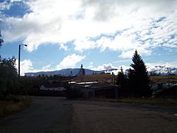
Lexington Mine in Walkerville
|
|

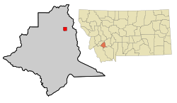
Location of Walkerville in Silver Bow County, Montana
|
|
| Country | |
| State | |
| County | Silver Bow |
| Area | |
| • Total | 2.23 sq mi (5.77 km2) |
| • Land | 2.23 sq mi (5.77 km2) |
| • Water | 0.00 sq mi (0.00 km2) |
| Elevation | 6,309 ft (1,923 m) |
| Population
(2020)
|
|
| • Total | 639 |
| • Density | 286.93/sq mi (110.81/km2) |
| Time zone | UTC-7 (Mountain (MST)) |
| • Summer (DST) | UTC-6 (MDT) |
| ZIP code |
59701
|
| Area code(s) | 406 |
| FIPS code | 30-77650 |
| GNIS feature ID | 0792762 |
Walkerville is a small town in Silver Bow County, Montana, USA. It's like a special area completely surrounded by the bigger city of Butte. In 2020, about 639 people lived there.
Walkerville is close to Butte. It's the only other town in Silver Bow County that isn't part of Butte itself. Walkerville is part of a special historic area called the Butte-Anaconda Historic District. It shows what early mining camps were like between the 1890s and 1910s.
Contents
History of Walkerville: A Mining Town's Story
Walkerville is a suburb of Butte, Montana. It's home to some of the very first mining sites in the area. These sites brought many investors to Walkerville in the late 1800s.
How Walkerville Got Its Name
The town is named after four brothers: Joseph, Samuel, Matthew, and David Walker. They were from Salt Lake City. They bought a very profitable mine called the Alice mine. This happened because their agent, Marcus Daly, suggested it. Marcus Daly later became a famous "Copper King."
Mining and Economic Changes
Miners dug up different materials depending on the location. Copper and silver were two of the most common. In 1893, silver prices dropped a lot. But the town's economy kept doing well because of its copper production.
Walkerville officially became a town in 1890. By the early 1900s, almost 2,500 people lived there. Most of them were immigrants from Cornwall and Ireland. They came to work in the mines. Walkerville's economy stayed strong until 1918. That's when World War I ended, causing copper prices to fall.
The Open-Pit Mining Era
In 1955, the Anaconda Company decided to start open-pit mining. This changed Walkerville a lot. Residents were against it because they thought it would take away jobs. But digging metals this way was cheaper. As copper prices dropped after World War II, the old Alice Mine turned into the Alice Pit.
Blasting in the pit, which was in the middle of Walkerville, made residents angry. They complained about noise, rocks flying, and cracks in their basements. The Anaconda Company offered to buy properties at fair prices. They also sold homes back to residents for one dollar. The only rule was that the home had to be moved. Many people moved away.
When blasting made Sibyl, Rose, and Pearl streets unusable, they were closed off. Mayor Jimmy Shea demanded that the Company formally ask the city council to close the streets. This gave the city council power. They demanded the Company pay to fix city utilities, build a new road, repair damaged streets, build safety fences, keep the pit far from homes, and build a new ballpark. The Company eventually agreed to most of these demands.
Even so, Walkerville's fight with the Company became more difficult. The pit kept getting bigger. In 1961, the City of Walkerville sued Anaconda for damaging city property. The Alice Pit never reopened after that.
Abandoned Mines Today
By 2015, almost all of the town's many mines were abandoned. Some of these old sites have become very dangerous. Plans are being made to fix them or remove them for safety.
Geography of Walkerville
Berkeley Pit is about 2 miles (3.2 km) to the south of Walkerville. The town is located on the U.S. Continental Divide. This means that water on one side flows to the Atlantic Ocean, and water on the other side flows to the Pacific Ocean.
According to the United States Census Bureau, the town covers a total area of 2.23 square miles (5.77 km²). All of this area is land.
Walkerville Neighborhoods
Walkerville has several unique neighborhoods:
- Corktown
- Sun View Terrace
- Seldom Seen
- Dewey's Point
- Chicken Flat
- Butchertown
- the Corra
Butchertown was named after Rollo Butcher. He was Walkerville's first permanent resident.
Population and People
| Historical population | |||
|---|---|---|---|
| Census | Pop. | %± | |
| 1880 | 444 | — | |
| 1890 | 1,743 | 292.6% | |
| 1900 | 2,621 | 50.4% | |
| 1910 | 2,491 | −5.0% | |
| 1920 | 2,391 | −4.0% | |
| 1930 | 2,052 | −14.2% | |
| 1940 | 1,880 | −8.4% | |
| 1950 | 1,631 | −13.2% | |
| 1960 | 1,453 | −10.9% | |
| 1970 | 1,097 | −24.5% | |
| 1980 | 887 | −19.1% | |
| 1990 | 605 | −31.8% | |
| 2000 | 714 | 18.0% | |
| 2010 | 675 | −5.5% | |
| 2020 | 639 | −5.3% | |
| U.S. Decennial Census | |||
Walkerville in 2010
Based on the census from 2010, there were 675 people living in Walkerville. These people lived in 304 households, and 175 of these were families. The town had about 302.7 people per square mile (116.9 per km²). There were 344 housing units, with about 154.3 units per square mile (59.6 per km²).
Most of the people in town were White (93.2%). There were also small percentages of African American (0.1%), Native American (3.3%), Asian (0.6%), and Pacific Islander (0.3%) residents. About 0.3% were from other races, and 2.2% were from two or more races. About 3.9% of the population identified as Hispanic or Latino.
About 27.6% of households had children under 18 living with them. About 41.4% were married couples. About 10.2% had a female head of household with no husband present. About 5.9% had a male head of household with no wife present. And 42.4% were not families. About 35.2% of all households were made up of individuals. About 13.2% had someone living alone who was 65 years old or older. The average household had 2.22 people, and the average family had 2.90 people.
The average age in Walkerville was 44.2 years. About 22.4% of residents were under 18. About 8.6% were between 18 and 24. About 20.3% were from 25 to 44. About 33.8% were from 45 to 64. And 15% were 65 years of age or older. The town's population was 48.6% male and 51.4% female.
Media and Education
Local Radio Station
The FM radio station KMTZ is licensed in Walkerville. It plays adult hits music.
Schools in Walkerville
Walkerville is part of the Butte Elementary School District and Butte High School District. Butte Public Schools manages both of these school districts.
See also
 In Spanish: Walkerville (Montana) para niños
 | Lonnie Johnson |
 | Granville Woods |
 | Lewis Howard Latimer |
 | James West |


