Sinai Peninsula facts for kids
 |
|
| Area | 60,000 km 2(23,000 sq mi) |
|---|---|
| Population | 600,000 |
| Countries | |
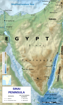
The Sinai Peninsula or Sinai (Arabic: سيناء Sīnā) is a triangle-shaped piece of land in Egypt. It's about 60,000 km2 (23,000 sq mi) big. It sits between the Mediterranean Sea in the north and the Red Sea in the south. It's special because it's the only part of Egypt that's actually in Asia. This is because the Sinai acts like a natural land bridge connecting two continents. Around 500,000 people live there. Egyptians sometimes call the Sinai the "Land of Fayrouz," which means "Turquoise Land," based on an Ancient Egyptian name "Dumafkat."
A Look at Sinai's History
Many important events and battles have happened in the Sinai. It has been ruled by different Egyptian governments over time. These include the Ayyubids, the Mamluks, the Muhammad Ali Dynasty, and the modern Egyptian republic. Other powerful groups also controlled it, like the Ottoman Empire and the United Kingdom (from 1882 to 1956).
Israel took control of Sinai twice: first during the Suez Crisis in 1956, and again during the Six-Day War in 1967. On October 6, 1973, Egypt started the October War to get the Sinai back.
Sinai Today: A Place to Visit
In 1982, after the Israel-Egypt Peace Treaty of 1979, Israel left Sinai. Since then, the region has become a popular tourist destination. People love to visit because of its beautiful natural scenery, amazing coral reefs for diving, and its important biblical history. Mount Sinai is a very sacred place for many religions, especially Abrahamic religions.
Images for kids
-
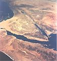
This image from the Gemini 11 spacecraft shows part of Egypt and the Sinai Peninsula in the front, with the Levant in the background.
-
St. Catherine's Monastery is the oldest working Christian monastery in the world and a very popular place for tourists to visit on the peninsula.
-
The border between Egypt and Israel, looking north from the Eilat Mountains.
-
Two young Bedouins making bread in the desert.
See also
 In Spanish: Península del Sinaí para niños
 | Ernest Everett Just |
 | Mary Jackson |
 | Emmett Chappelle |
 | Marie Maynard Daly |


