
Sinclair, Wyoming facts for kids
Quick facts for kids
Sinclair, Wyoming
|
|
|---|---|

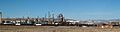
Sinclair Oil Refinery (2008)
|
|

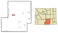
Location of Sinclair in Carbon County, Wyoming.
|
|

Sinclair, Wyoming
Location in Wyoming

Sinclair, Wyoming
Location in the United States
|
|
| Country | United States |
| State | Wyoming |
| County | Carbon |
| Area | |
| • Total | 2.43 sq mi (6.30 km2) |
| • Land | 2.43 sq mi (6.30 km2) |
| • Water | 0.00 sq mi (0.00 km2) |
| Elevation | 6,588 ft (2,008 m) |
| Population
(2010)
|
|
| • Total | 433 |
| • Estimate
(2019)
|
395 |
| • Density | 162.48/sq mi (62.73/km2) |
| Time zone | UTC-7 (Mountain (MST)) |
| • Summer (DST) | UTC-6 (MDT) |
| ZIP code |
82334
|
| Area code(s) | 307 |
| FIPS code | 56-71150 |
| GNIS feature ID | 1609153 |

Sinclair is a small town located in Carbon County, Wyoming, in the United States. It is known for its oil refinery.
Contents
History of Sinclair
The town of Sinclair was first called Parco. This name came from the Producers & Refiners Corporation (PARCO), which built an oil refinery and created the town around it. A "company town" is a place where most homes and businesses are owned by one company.
Later, during the Great Depression, a company called Sinclair Consolidated Oil Corporation bought PARCO. Because of this, the town's name was changed to Sinclair. The original refinery is still used today. In 2010, 433 people lived in Sinclair.
The town was carefully planned and built between 1924 and 1925. Architects from Denver, Fisher & Fisher, designed the buildings in a Spanish Colonial Revival style. This style often includes red tile roofs, stucco walls, and arched doorways. The oldest part of town is now called the Parco Historic District.
Nearby Historic Sites
Just six miles east of Sinclair, you can find the site of a ghost town called Benton, Wyoming. In 1868, Benton was the end of the line for the Union Pacific Railroad. It was a very busy place for about three months. Many people passed through, including Ulysses S. Grant, who later became a U.S. President. It was also the last stop for wagon trains on the Mormon Trail before the railroad was finished.
Three miles east of Benton is the Fort Fred Steele State Historic Site. This fort was named after American Civil War General Frederick Steele. It was built in 1868 to protect the Union Pacific Railway as it expanded west. The fort was closed in 1886. Many of its buildings were sold and moved to other places. The small community that grew around the fort continued until 1939. Today, the Wyoming State Legislature helps protect what is left of the historic fort.
Geography and Location
Sinclair is located in Wyoming at coordinates 41.780782 degrees North and -107.116826 degrees West.
The United States Census Bureau says that the town covers an area of about 2.43 square miles (6.30 square kilometers). All of this area is land, with no large bodies of water.
Population and People
| Historical population | |||
|---|---|---|---|
| Census | Pop. | %± | |
| 1930 | 727 | — | |
| 1940 | 604 | −16.9% | |
| 1950 | 775 | 28.3% | |
| 1960 | 621 | −19.9% | |
| 1970 | 445 | −28.3% | |
| 1980 | 586 | 31.7% | |
| 1990 | 500 | −14.7% | |
| 2000 | 423 | −15.4% | |
| 2010 | 433 | 2.4% | |
| 2019 (est.) | 395 | −8.8% | |
| U.S. Decennial Census | |||
How Many People Live Here?
In 2010, a census (a count of people) showed that 433 people lived in Sinclair. There were 170 households, which means 170 different groups of people living together. Most people in Sinclair were White. A small number were Native American, Asian, or from other backgrounds. About 6.5% of the population was Hispanic or Latino.
Many households (32.4%) had children under 18 living with them. Most households (64.7%) were married couples. The average household had about 2.5 people. The average age of people in Sinclair was 39.5 years old.
Education in Sinclair
Children in Sinclair attend public schools run by Carbon County School District #1.
- Rawlins Elementary School serves students from kindergarten to 5th grade.
- Rawlins Middle School is for students in 6th to 8th grade.
- Rawlins High School is for older students in 9th to 12th grade.
Sinclair also has a public library. It is part of the Carbon County Library System, where kids can find books and other resources.
Images for kids
-
Sinclair Oil Refinery (2008)
-
Location of Sinclair in Carbon County, Wyoming.
See also
 In Spanish: Sinclair (Wyoming) para niños
