
Sister Superior (Utah) facts for kids
Quick facts for kids Sister Superior |
|
|---|---|

Sister Superior
|
|
| Highest point | |
| Elevation | 6,037 ft (1,840 m) |
| Prominence | 497 ft (151 m) |
| Parent peak | The Rectory |
| Geography | |

Sister Superior
Location in Utah

Sister Superior
Location in the United States
|
|
| Location | Grand County, Utah United States |
| Parent range | Colorado Plateau |
| Topo map | USGS Fisher Towers |
| Type of rock | Wingate Sandstone |
| Climbing | |
| First ascent | 1965 |
| Easiest route | Climbing class 5.10 |
Sister Superior is a tall rock formation in Utah, United States. It stands 6,037 feet (about 1,840 meters) high. This amazing sandstone peak is found in Grand County. It is located between Professor Valley and Castle Valley, close to the city of Moab.
Sister Superior is a very thin tower. It has vertical walls made of Wingate Sandstone that are over 300 feet tall. These walls sit on a base of other rock layers. The tower is what is left of an eroded butte, which is a flat-topped hill with steep sides. The closest taller peak is The Rectory, which is about 1.2 miles (1.9 km) to the south. Further south from Sister Superior is Castleton Tower. Rainwater from Sister Superior flows into the nearby Colorado River. The first time someone successfully climbed Sister Superior was on May 17, 1965. This climb was done by Harvey Carter and David Bentley.
Contents
Climbing Sister Superior
Sister Superior is a popular spot for rock climbing. Climbers come from all over to test their skills on its steep walls. The rock is mostly sandstone, which can be challenging to climb.
Popular Climbing Routes
There are several well-known paths climbers take to reach the top. Each route has a different difficulty level. Here are some of the routes:
- Jah Man - This route is rated class 5.10c and takes about 5 sections to climb.
- Black Sabbath - This route is rated class 5.11 and takes about 4 sections.
- Absolution - This route is rated class 5.11 and takes about 3 sections.
- The GAG Route - This route is rated class 5.10d and takes about 4 sections.
Weather at Sister Superior

The weather around Sister Superior changes a lot between seasons. It is part of a high desert area. This means temperatures can swing widely during the day.
Best Times to Visit
Spring and fall are the best times to visit Sister Superior. During these seasons, the daytime temperatures are usually between 60 and 80 degrees Fahrenheit (15-27 °C). Nights are cooler, from 30 to 50 degrees Fahrenheit (-1-10 °C).
Summer and Winter Weather
Summers can be very hot, with temperatures often going above 100 degrees Fahrenheit (38 °C). Winters are cold. Highs are usually between 30 and 50 degrees Fahrenheit (-1-10 °C). Lows can drop to 0 to 20 degrees Fahrenheit (-18 - -7 °C). The area does not get much rain, usually less than 10 inches (25 cm) each year.
Images for kids
-
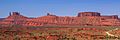
Left to right: Castleton Tower, The Rectory, Sister Superior, Convent Mesa, Parriott Mesa, Highway 128
