Sleaford, South Australia facts for kids
Quick facts for kids SleafordSouth Australia |
|||||||||||||||
|---|---|---|---|---|---|---|---|---|---|---|---|---|---|---|---|

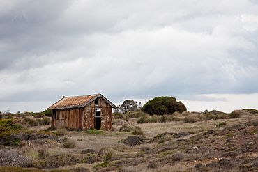
Old shack in Sleaford
|
|||||||||||||||
| Established | 1871 | ||||||||||||||
| Postcode(s) | 5607 | ||||||||||||||
| Time zone | ACST (UTC+9:30) | ||||||||||||||
| • Summer (DST) | ACST (UTC+10:30) | ||||||||||||||
| Location |
|
||||||||||||||
| LGA(s) | District Council of Lower Eyre Peninsula | ||||||||||||||
| Region | Eyre Western | ||||||||||||||
| County | Flinders | ||||||||||||||
| State electorate(s) | Flinders | ||||||||||||||
| Federal Division(s) | Grey | ||||||||||||||
|
|||||||||||||||
|
|||||||||||||||
| Footnotes | Location Coordinates Climate Adjoining localities |
||||||||||||||
Sleaford is a cool place in South Australia. It's located at the very bottom tip of the Eyre Peninsula. From Sleaford, you can see the huge Great Australian Bight ocean!
Sleaford is about 260 kilometers west of Adelaide, which is the capital city of South Australia. It's also only about 17 kilometers southwest of Port Lincoln, a nearby town.
About Sleaford
The area of Sleaford was officially named in October 2003. Its name comes from a nearby bay called Sleaford Bay. The borders of Sleaford have been adjusted a couple of times, in 2006 and 2011, especially near the area of Tulka.
Sleaford covers the southern part of the Eyre Peninsula. It stretches from the western side of Proper Bay, near Port Lincoln, all the way along the coast. This coastline faces the Great Australian Bight. It also includes part of Sleaford Bay and the western side of the Jussieu Peninsula.
History of the Area
The land that makes up Sleaford is mostly the same as an old land division called the Hundred of Sleaford. This "Hundred" was created way back in 1871 by Governor Fergusson. It was also named after Sleaford Bay.
Nature and Conservation
The land in Sleaford is used for two main things: farming and protecting nature. There are special protected areas here. These include parts of the Lincoln National Park and the Sleaford Mere Conservation Park. These parks help keep the local plants and animals safe.
Sleaford is also home to the old Fishery Bay Whaling Station. This station, located at Fishery Bay, is a very important historical site. It is listed on the South Australian Heritage Register, which means it's protected because of its history.
People and Government
In August 2016, a survey counted the number of people living in Sleaford. At that time, there were 46 residents.
Sleaford is part of different government areas. For national elections, it's in the Division of Grey. For state elections, it's in the electoral district of Flinders. Locally, it's managed by the District Council of Lower Eyre Peninsula.
You can also find the Whalers Way Orbital Launch Complex in Sleaford. This is a place where rockets might be launched into space!
 | Percy Lavon Julian |
 | Katherine Johnson |
 | George Washington Carver |
 | Annie Easley |


