
Smith's Ferry, Holyoke, Massachusetts facts for kids
Quick facts for kids
Smith's Ferry
|
|
|---|---|

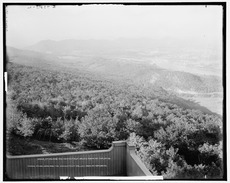
Riverside clubhouse of the Holyoke Canoe Club, Smith's Ferry
|
|

Smith's Ferry
Location in Holyoke

Smith's Ferry
Location in Massachusetts

Smith's Ferry
Location in the United States
|
|
| Country | United States |
| State | Massachusetts |
| City | Holyoke |
| Wards | 7 |
| Precincts | 7A |
| Annexed | June 9, 1909 |
| Area | |
| • Total | 5.94 sq mi (15.4 km2) |
| Elevation | 128 ft (39 m) |
| ZIP code |
01040
|
| Area code(s) | 413 |
| GNIS feature ID | 609085 |
Smith's Ferry is a neighborhood in Holyoke, Massachusetts, United States. It is located north of the city center. This area is about 1.5 miles (2.4 km) from downtown Holyoke.
Smith's Ferry is home to the Mount Tom State Reservation. You can also find the Mountain Park Amphitheater here. The Dinosaur Footprints Reservation is another cool spot. This neighborhood has many places for fun and learning about history. It is the second largest area in Holyoke. Smith's Ferry covers about 3,800 acres (1,500 ha). It has homes, businesses, and recreational areas.
Contents
History of Smith's Ferry


Smith's Ferry is named after the people who operated ferries. These ferries crossed the Connecticut River. They were used before bridges like the Joseph E. Muller Bridge were built. The first ferry started in 1658. Ferries continued to operate until the early 1900s.
By 1704, about six families lived in Smith's Ferry. They often gathered in one house at night for safety. This was to protect themselves from attacks. On May 13, 1704, some tribesmen attacked Easthampton. This event was called the Pascommuck Massacre. Later, some of these men attacked Smith's Ferry. They crossed the Mount Tom Range. They set fire to Benjamin Wright's home. The villagers fought back and stopped them.
Smith's Ferry was once part of Northampton. It was known as the Old Mountain Division East Lots. A small piece of land in Easthampton separated it from Northampton. Even though Northampton governed the land, Holyoke's fire department often responded to emergencies there.
Joining Holyoke: The Annexation Story
In 1908, people suggested that Smith's Ferry should join Holyoke. However, the Holyoke Canoe Club and a country club did not agree. They wanted the entire area to be annexed, not just parts of it.
A big event helped the idea of joining Holyoke. On March 21, 1909, the canoe club's building burned down. Sparks from a train started a grass fire. Some boys saw the fire and ran to get help. They told J. Lewis Wyckoff, an important person in the community. The alarm was sent to the Holyoke fire station.
The Northampton fire department could not respond. Their roads were in bad condition and too far away. By the time Holyoke firefighters arrived, the building was completely lost. But they stopped the fire from spreading to nearby railroad tracks. The canoe club paid the Holyoke firefighters for their help. This made Northampton upset.
A newspaper criticized the situation. It said Northampton told Smith's Ferry residents to be happy with poor services. It also said Holyoke was criticized for offering help. This fire became a main reason for the call to join Holyoke. Weeks later, a group from the state legislature visited the burned clubhouse.

Residents of Smith's Ferry were tired of poor services. They asked to join Holyoke. On June 9, 1909, the Massachusetts Legislature passed a law. This law allowed Smith's Ferry to become part of Holyoke. J. Lewis Wyckoff received the key to the city for his efforts.
The city of Holyoke had to pay money for this change. They paid $7,000 to Hampshire County. This was for building a state road in the area. Holyoke also paid Northampton $55,000 for the land. The total cost was $62,000 at that time. This would be about $1.5 million in today's money.
In the 1900s, Smith's Ferry was home to the Mount Tom Station. This was the last coal power plant in Massachusetts. It closed in 2014. The Mount Tom Greenhouse company was another business here. It grew flowers from about 1950 to 1981. Today, the Jericho community center is in the area. It helps children and adults with disabilities.
Geography of Smith's Ferry
Rocks and Landforms
Smith's Ferry has a special mix of rocks. It has both sedimentary and igneous rocks. This is because it is near a Mesozoic Rift Basin. Long ago, lava flowed here from volcanoes. This happened when the supercontinent Pangaea broke apart. Some of these breaks in the Earth's crust created igneous rock deposits. You can see these along the Connecticut River Valley.
Volcanic activity from the Jurassic period shaped the land. It left behind Holyoke and black-rock diabase. Holyoke diabase formed from lava flowing on the surface. Black-rock diabase formed when lava was forced through layers of underground sandstone. Basalt is also found here from past volcanoes.
Next to these igneous rocks are sedimentary rocks. Large areas of sandy sandstone are along the Connecticut River. You can find dinosaur tracks on this sandstone. These tracks were once very common. Landowners would often cut them out and sell them to tourists. Building the I-91 highway near Mount Tom was delayed in the 1960s. This happened when dinosaur slabs were found during blasting.
Getting Around Smith's Ferry
Roads and Highways
The main road in Smith's Ferry is U.S. Route 5. It runs through the entire area. The PVTA bus route B48 uses this highway. However, it does not have marked stops in Smith's Ferry. This part of the highway also has a bike lane. It is separated from traffic by a painted line.
U.S. Interstate 91 forms part of the boundary of Mount Tom State Reservation. You can get onto I-91 north or south of the neighborhood. Exit 18 is in Northampton to the north. Exit 17 is on MA Route 141 to the south.
Train Travel
The railway in Smith's Ferry was once part of the Connecticut River Railroad system. It had a passenger station that served the Mount Holyoke Seminary in the 1800s. Today, there are no passenger or freight stops in Smith's Ferry. However, the tracks are still used by Pan Am Southern. This company operates a freight line. It runs from Hartford to White River Junction.
The railroad is also part of the Vermonter Amtrak route. This train service started between Holyoke and Northampton stations in August 2015.
