South Bay, Florida facts for kids
Quick facts for kids
South Bay, Florida
|
||
|---|---|---|
| City of South Bay | ||
 |
||
|
||
| Motto(s):
"Cross Roads of South Florida"
|
||

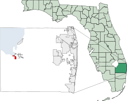
Location of South Bay, Florida
|
||
| Country | ||
| State | ||
| County | ||
| Incorporation | 1941 | |
| Government | ||
| • Type | Commissioner-Manager | |
| Area | ||
| • Total | 3.93 sq mi (10.17 km2) | |
| • Land | 2.86 sq mi (7.41 km2) | |
| • Water | 1.06 sq mi (2.76 km2) | |
| Elevation | 20 ft (6 m) | |
| Population
(2020)
|
||
| • Total | 4,860 | |
| • Density | 1,698.11/sq mi (655.76/km2) | |
| Time zone | UTC-5 (Eastern (EST)) | |
| • Summer (DST) | UTC-4 (EDT) | |
| ZIP code |
33493
|
|
| Area code(s) | 561, 728 | |
| FIPS code | 12-67175 | |
| GNIS feature ID | 0291340 | |
| Website | City of South Bay Florida | |
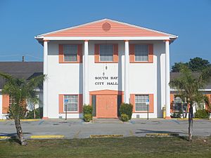
South Bay is a city located in Palm Beach County, Florida, in the United States. It is the westernmost city in the South Florida metropolitan area. In 2020, the U.S. Census Bureau reported that 4,860 people lived in South Bay. Even though the city itself has about 4,000 residents, the population in the surrounding areas is much larger. About 54,000 people live within 25-mile (40 km) of South Bay, and over 1.4 million people live within 50-mile (80 km).
Contents
History of South Bay
South Bay got its name because of its location on Lake Okeechobee. The town officially became a city in 1941. The first mayor of South Bay was Aubrey "Orb" Walker. He and his brother, Haughty D. Walker, survived the big hurricane of 1928 by getting their family onto a boat in the canal.
Geography of South Bay
South Bay is located at 26°39′59″N 80°43′8″W / 26.66639°N 80.71889°W. This is near the southern edge of Lake Okeechobee.
The city covers a total area of about 3.7 square miles (9.6 km2). Most of this is land, about 2.7 square miles (7.0 km2). The rest, about 1.0 square mile (2.6 km2), is water. The Lake Okeechobee Scenic Trail, a popular pathway, goes right through South Bay.
South Bay's Climate
South Bay has a warm climate. Here's a look at the typical weather:
| Climate data for South Bay 15 S, Florida, 1991–2020 normals, extremes 2002–present | |||||||||||||
|---|---|---|---|---|---|---|---|---|---|---|---|---|---|
| Month | Jan | Feb | Mar | Apr | May | Jun | Jul | Aug | Sep | Oct | Nov | Dec | Year |
| Record high °F (°C) | 87 (31) |
89 (32) |
92 (33) |
95 (35) |
94 (34) |
97 (36) |
98 (37) |
98 (37) |
96 (36) |
93 (34) |
92 (33) |
89 (32) |
98 (37) |
| Mean maximum °F (°C) | 84.1 (28.9) |
85.9 (29.9) |
88.1 (31.2) |
90.8 (32.7) |
91.9 (33.3) |
93.7 (34.3) |
94.9 (34.9) |
94.3 (34.6) |
92.9 (33.8) |
90.9 (32.7) |
87.0 (30.6) |
85.1 (29.5) |
95.5 (35.3) |
| Mean daily maximum °F (°C) | 75.6 (24.2) |
78.1 (25.6) |
80.4 (26.9) |
84.0 (28.9) |
87.3 (30.7) |
89.6 (32.0) |
91.3 (32.9) |
91.3 (32.9) |
89.5 (31.9) |
86.3 (30.2) |
81.5 (27.5) |
77.6 (25.3) |
84.4 (29.1) |
| Daily mean °F (°C) | 63.8 (17.7) |
66.3 (19.1) |
68.7 (20.4) |
72.5 (22.5) |
76.8 (24.9) |
80.7 (27.1) |
82.1 (27.8) |
82.5 (28.1) |
81.0 (27.2) |
76.9 (24.9) |
70.8 (21.6) |
66.5 (19.2) |
74.0 (23.3) |
| Mean daily minimum °F (°C) | 52.0 (11.1) |
54.4 (12.4) |
57.0 (13.9) |
61.0 (16.1) |
66.3 (19.1) |
71.9 (22.2) |
72.8 (22.7) |
73.7 (23.2) |
72.5 (22.5) |
67.4 (19.7) |
60.2 (15.7) |
55.4 (13.0) |
63.7 (17.6) |
| Mean minimum °F (°C) | 34.9 (1.6) |
38.5 (3.6) |
42.5 (5.8) |
50.1 (10.1) |
57.7 (14.3) |
67.5 (19.7) |
69.9 (21.1) |
70.7 (21.5) |
68.2 (20.1) |
55.5 (13.1) |
45.1 (7.3) |
41.6 (5.3) |
32.6 (0.3) |
| Record low °F (°C) | 26 (−3) |
30 (−1) |
35 (2) |
42 (6) |
50 (10) |
64 (18) |
67 (19) |
69 (21) |
64 (18) |
43 (6) |
35 (2) |
28 (−2) |
26 (−3) |
| Average precipitation inches (mm) | 2.50 (64) |
2.30 (58) |
2.81 (71) |
2.89 (73) |
4.78 (121) |
9.63 (245) |
7.93 (201) |
8.49 (216) |
7.45 (189) |
4.05 (103) |
2.22 (56) |
2.11 (54) |
57.16 (1,452) |
| Source: NOAA (mean maxima/minima 2006–present) | |||||||||||||
Transportation in South Bay
South Bay is an important crossroads. Two main roads meet here:
- State Road 80, which runs east-west.
- U.S. 27, which runs north-south.
Mayors of South Bay
The city of South Bay has had several mayors over the years. Here is a list of some of them:
| Image | Mayor | Years of service | Notes |
|---|---|---|---|
| John Deaton | ?–1974 | ||
| Vernita Cox | 1974 1974–1975 |
First African American mayor in Palm Beach county. She was named mayor by the City Council after the previous mayor, John Deaton, resigned. | |
| Jay S. Smith | 1975–1976 | ||
| Donald Tanner | 1976–1977 | ||
| Billy Wells | 1977–1978 | ||
| ?–? | |||
| ?–? | |||
| Donald Tanner | ?–1984 | ||
| Clarence E. Anthony | 1984–2008 | ||
| Shirley Walker Turner | 2008–2012 | ||
| Shanique Scott | 2012–2016 | ||
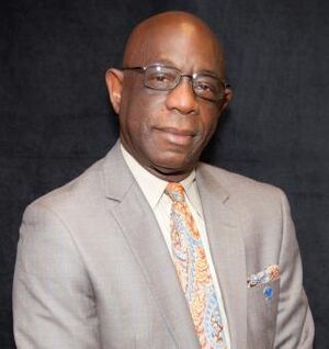
| Joe Kyles | 2016–Present |
Population of South Bay
The population of South Bay has changed over the years. Here's how many people have lived in the city according to the U.S. Decennial Census:
| Historical population | |||
|---|---|---|---|
| Census | Pop. | %± | |
| 1950 | 1,050 | — | |
| 1960 | 1,631 | 55.3% | |
| 1970 | 2,958 | 81.4% | |
| 1980 | 3,886 | 31.4% | |
| 1990 | 3,558 | −8.4% | |
| 2000 | 3,859 | 8.5% | |
| 2010 | 4,876 | 26.4% | |
| 2020 | 4,860 | −0.3% | |
| U.S. Decennial Census | |||
2020 Census Information
The 2020 United States census showed that 4,860 people lived in South Bay. There were 787 households and 614 families in the city.
Here's a breakdown of the different groups of people living in South Bay in 2020 (not including Hispanic people in the racial categories):
| Race | Number | Percentage |
|---|---|---|
| White (NH) | 580 | 11.93% |
| Black or African American (NH) | 3,097 | 63.72% |
| Native American or Alaska Native (NH) | 2 | 0.04% |
| Asian (NH) | 2 | 0.04% |
| Pacific Islander or Native Hawaiian (NH) | 1 | 0.02% |
| Some other race (NH) | 7 | 0.14% |
| Two or more races/Multiracial (NH) | 73 | 1.50% |
| Hispanic or Latino (any race) | 1,098 | 22.59% |
| Total | 4,860 |
2010 Census Information
In the 2010 United States census, South Bay had a population of 4,876 people. There were 843 households and 746 families living in the city.
Here's how South Bay's population compared to Palm Beach County and Florida in 2010:
| South Bay Demographics in 2010 | |||
|---|---|---|---|
| 2010 Census | South Bay | Palm Beach County | Florida |
| Total population | 4,876 | 1,320,134 | 18,801,310 |
| Population, percent change, 2000 to 2010 | +26.4% | +16.7% | +17.6% |
| Population density | 1,819.4/sq mi | 670.2/sq mi | 350.6/sq mi |
| White or Caucasian (including White Hispanic) | 24.6% | 73.5% | 75.0% |
| (Non-Hispanic White or Caucasian) | 11.4% | 60.1% | 57.9% |
| Black or African-American | 64.0% | 17.3% | 16.0% |
| Hispanic or Latino (of any race) | 23.2% | 19.0% | 22.5% |
| Asian | 0.5% | 2.4% | 2.4% |
| Native American or Native Alaskan | 0.1% | 0.5% | 0.4% |
| Pacific Islander or Native Hawaiian | 0.0% | 0.1% | 0.1% |
| Two or more races (Multiracial) | 0.6% | 2.3% | 2.5% |
| Some Other Race | 0.0% | 3.9% | 3.6% |
See also
 In Spanish: South Bay (Florida) para niños
 | Delilah Pierce |
 | Gordon Parks |
 | Augusta Savage |
 | Charles Ethan Porter |


