South Dennis, Massachusetts facts for kids
Quick facts for kids
South Dennis, Massachusetts
|
|
|---|---|

|
|

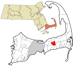
Location in Barnstable County and the state of Massachusetts.
|
|
| Country | United States |
| State | Massachusetts |
| County | Barnstable |
| Town | Dennis |
| Area | |
| • Total | 4.75 sq mi (12.30 km2) |
| • Land | 4.55 sq mi (11.79 km2) |
| • Water | 0.20 sq mi (0.52 km2) |
| Elevation | 33 ft (10 m) |
| Population
(2020)
|
|
| • Total | 3,899 |
| • Density | 856.92/sq mi (330.84/km2) |
| Time zone | UTC-5 (Eastern (EST)) |
| • Summer (DST) | UTC-4 (EDT) |
| ZIP code |
02660
|
| Area code(s) | 508 |
| FIPS code | 25-63655 |
| GNIS feature ID | 0615880 |
South Dennis is a special area in the town of Dennis, located in Barnstable County, Massachusetts, United States. It's called a census-designated place (CDP). This means it's a specific area that the government counts for population, but it's not an officially separate town. In 2010, about 3,643 people lived here, making it the largest CDP in Dennis.
Contents
Exploring South Dennis's Location and Size
South Dennis is found on Cape Cod, right in the middle of the town of Dennis. It's surrounded by several other towns and CDPs. To the northeast, you'll find Brewster. To the southeast is Harwich.
South Dennis's Neighbors
South of South Dennis are the CDPs of Dennis Port and West Dennis. To the west is the town of Yarmouth. North of South Dennis are the CDPs of Dennis and East Dennis.
Land and Water Areas
The United States Census Bureau says that South Dennis covers a total area of about 12.3 square kilometers (4.75 square miles). Most of this area, about 11.8 square kilometers (4.55 square miles), is land. The rest, about 0.5 square kilometers (0.20 square miles), is water. This means about 4.19% of South Dennis is covered by water.
Who Lives in South Dennis?
| Historical population | |||
|---|---|---|---|
| Census | Pop. | %± | |
| 2020 | 3,899 | — | |
| U.S. Decennial Census | |||
In 2000, there were 3,679 people living in South Dennis. These people lived in 1,681 households, and 1,059 of these were families. The population density was about 312 people per square kilometer (808 people per square mile).
Diversity in South Dennis
Most people in South Dennis are White, making up about 95.41% of the population. Other groups include African American (1.01%), Native American (0.60%), and Asian (0.35%). About 1.30% of the population identified as Hispanic or Latino.
Households and Families
About 23.7% of households in South Dennis had children under 18 living there. Nearly half, 48.7%, were married couples. About 10.9% of households had a female head with no husband present. The average household had 2.19 people, and the average family had 2.74 people.
Age Groups in the Community
The population in South Dennis is spread out across different age groups. About 20.3% of the people were under 18 years old. About 24.6% were 65 years or older. The median age, which is the middle age of all the people, was 46 years old.
Income Levels
In 2000, the average income for a household in South Dennis was $40,330. For families, the average income was $47,935. A small number of families (2.0%) and individuals (3.2%) lived below the poverty line. This included 0.7% of those under 18 and 3.7% of those 65 or older.
Learning in South Dennis
South Dennis is home to the N. H. Wixon Innovation School. This public school teaches students in grades 4 and 5.
About N. H. Wixon Innovation School
The school is named after Nathaniel H. Wixon. He was a well-known fisherman from Dennisport. He was also a descendant of some of the original Mayflower Pilgrims.
See also
 In Spanish: South Dennis (Massachusetts) para niños
 | James Van Der Zee |
 | Alma Thomas |
 | Ellis Wilson |
 | Margaret Taylor-Burroughs |

